
Siegen-Wittgenstein | |
|---|---|
 Flag  Coat of arms | |
 | |
| Country | Germany |
| State | North Rhine-Westphalia |
| Adm. region | Arnsberg |
| Capital | Siegen |
| Government | |
| • District admin. | Andreas Müller (SPD) |
| Area | |
| • Total | 1,131.47 km2 (436.86 sq mi) |
| Population (31 December 2022)[1] | |
| • Total | 277,136 |
| • Density | 240/km2 (630/sq mi) |
| Time zone | UTC+01:00 (CET) |
| • Summer (DST) | UTC+02:00 (CEST) |
| Vehicle registration | BLB, SI |
| Website | siegen-wittgenstein.de |
Siegen-Wittgenstein is a Kreis (district) in the southeast of North Rhine-Westphalia, Germany. Neighboring districts are Olpe, Hochsauerlandkreis, Waldeck-Frankenberg, Marburg-Biedenkopf, Lahn-Dill, Westerwaldkreis, and Altenkirchen.
YouTube Encyclopedic
-
1/5Views:5751 73435 1965 948576
-
Siegen-Wittgenstein
-
Dein Wittgenstein Wittgenstein - Imagefilm
-
Der Herbst im schönen Siegerland | WDR Reisen
-
"SIEGEN" Top 11 Tourist Places | Siegen Tourism | GERMANY
-
Der geographischer Mittelpunkt von Siegen-Wittgenstein
Transcription
History
In 1816–1817, the two districts of Siegen and Wittgenstein were created as parts of the Prussian province of Westphalia. In 1974, the two districts were merged, and in 1984 the name Siegen-Wittgenstein was adopted.
Geography
Geographically, it covers the hills southeast of the Sauerland hills, the Siegerland and Wittgensteiner Land.
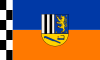
Coat of arms
The two upper sections show, to the right, the arms of the Dukes of Nassau, who founded Siegen, and to the left, those of the Counts of Sayn-Wittgenstein. At the bottom a miner's lamp and a coppicing hook are depicted, in reference to the mining and charcoal-burning history of the district.
Towns and municipalities

- Municipalities
References
External links
 Media related to Kreis Siegen-Wittgenstein at Wikimedia Commons
- Official webpage (in German)
- History and genealogy for Wittgenstein
50°55′N 8°10′E / 50.92°N 8.17°E

| International | |
|---|---|
| National | |
This Siegen-Wittgenstein district location article is a stub. You can help Wikipedia by expanding it. |