
Mettmann | |
|---|---|
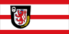 Flag  Coat of arms | |
 | |
| Country | Germany |
| State | North Rhine-Westphalia |
| Adm. region | Düsseldorf |
| Capital | Mettmann |
| Government | |
| • District admin. | Thomas Hendele (CDU) |
| Area | |
| • Total | 407.09 km2 (157.18 sq mi) |
| Population (31 December 2021)[1] | |
| • Total | 484,411 |
| • Density | 1,200/km2 (3,100/sq mi) |
| Time zone | UTC+01:00 (CET) |
| • Summer (DST) | UTC+02:00 (CEST) |
| Vehicle registration | ME |
| Website | www.kreis-mettmann.de |
Mettmann (German pronunciation: [ˈmɛtman]) is a Kreis (district) in the middle of North Rhine-Westphalia, Germany. Neighboring are the Ennepe-Ruhr, Rhein-Kreis Neuss, Rheinisch-Bergischer Kreis and the district-free cities Cologne, Leverkusen, Wuppertal, Solingen, Düsseldorf, Duisburg, Mülheim, Essen. It is the most densely populated rural district in Germany; it borders Düsseldorf Airport in the northwestern district borders, on the city limits of Ratingen, and is also near Cologne Bonn Airport. It was named after Mettmann, its district seat.
YouTube Encyclopedic
-
1/1Views:787
-
[Sound] Bus MAN NG 313 (ME-WE 2803) der Fa Klingenfuß Linien- und Reiseverkehr GmbH, Velbert
Transcription
History
In the 12th century the area of today's district became the property of the earldom Berg. When Napoleon occupied the area in 1792 it became a canton in the arrondissement Düsseldorf.
After the Congress of Vienna the area went to Prussia in 1816 as part of the province Westphalia, and the first district Mettmann was created. This district was merged from 1820 till 1861 with the district Elberfeld, which then became a city in its own right, now it is part of Wuppertal. In 1877 the administrative seat was moved to Vohwinkel. In 1929 more of the area was given over to Wuppertal, and the district was merged with the district Düsseldorf (Landkreis, excluding the city itself), to form the district Düsseldorf-Mettmann, with administrative seat in Düsseldorf. In 1952 the seat went back to Mettmann, and after the last reorganization of 1975/76 the district got back the old name. The cities Langenfeld and Monheim were included into the district then, while Kettwig became part of the city Essen.
Geography
The district Mettmann is located just south of the Ruhr area, next to the big cities of Düsseldorf.
Most famous is the valley of the small river Düssel, the Neanderthal, where the fossils of the human species Neanderthals were first found.

Coat of arms
The red lion with the blue tongue is the sign of the earldom Berg. In the black border it has the symbols for the two most important industries of the district - the production of locks, and agriculture. The coat of arms was designed in 1936 by the painter and herald Pagenstecher from Düsseldorf.
Towns and municipalities
References
- ^ "Bevölkerung der Gemeinden Nordrhein-Westfalens am 31. Dezember 2021" (in German). Landesbetrieb Information und Technik NRW. Retrieved 20 June 2022.
External links
![]() Media related to Kreis Mettmann at Wikimedia Commons
Media related to Kreis Mettmann at Wikimedia Commons
- Official website (German)
- Official tourism website

51°15′N 7°00′E / 51.25°N 7.0°E
| International | |
|---|---|
| National | |