
Montes de Oca | |
|---|---|
 Fuente de la Hispanidad, roundabout under Route 39 and on Route 2 | |
 Flag  Seal | |
| Motto(s): Cuna de la Educación Superior (Cradle of Higher Education) | |
 Montes de Oca canton | |
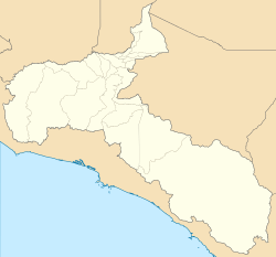 Montes de Oca Montes de Oca canton location in San José Province  Montes de Oca Montes de Oca canton location in Costa Rica | |
| Coordinates: 9°56′24″N 84°00′40″W / 9.940046°N 84.0110652°W | |
| Country | |
| Province | San José |
| Creation | 1 August 1915[1] |
| Named for | Don Faustino Montes de Oca |
| Head city | San Pedro |
| Districts | Districts |
| Government | |
| • Type | Municipality |
| • Body | Municipalidad de Montes de Oca |
| Area | |
| • Total | 15.16 km2 (5.85 sq mi) |
| Elevation | 1,262 m (4,140 ft) |
| Population (2011) | |
| • Total | 49,132 |
| • Density | 3,200/km2 (8,400/sq mi) |
| Time zone | UTC−06:00 |
| Canton code | 115 |
| Website | montesdeoca |
Montes de Oca is a canton in the San José province of Costa Rica.[2][3] The head city of the canton is San Pedro.
YouTube Encyclopedic
-
1/2Views:1 1211 402
-
Villafranca Montes de Oca | Burgos | España Fascinante
-
Lo que queda del Castillo de Alba (Montes de Oca)
Transcription
Toponymy
Its name honors a former congressional representative from the area, Don Faustino Montes de Oca (1859–1902).
History
Montes de Oca was created on 1 August 1915 by decree 45.[3]
Geography
Montes de Oca has an area of 15.16 km2[4] and a mean elevation of 1,262 metres.[2]
The elongated canton reaches from the suburbs of the national capital of San José eastward to the province of Cartago, and neighbors the cantons of Curridabat, San José, Cartago, and Goicoechea. The Torres River delineate a portion of the northern boundary, while the Ocloro River and Poró Creek mark the southern boundary.
Districts
The canton of Montes de Oca is subdivided into the following districts:
Demographics
| Historical population | |||
|---|---|---|---|
| Census | Pop. | %± | |
| 1927 | 3,676 | — | |
| 1950 | 9,916 | 169.7% | |
| 1963 | 24,043 | 142.5% | |
| 1973 | 33,633 | 39.9% | |
| 1984 | 39,065 | 16.2% | |
| 2000 | 50,433 | 29.1% | |
| 2011 | 49,132 | −2.6% | |
|
Instituto Nacional de Estadística y Censos[5] |
|||
For the 2011 census, Montes de Oca had a population of 49,132 inhabitants. [7]
The canton is known for its high level of commercial development, the number of universities and other centers of higher education, and its active night life. It is one of the most urbanized and vibrant cantons in the San José area, both day and night.
Montes de Oca ranks first in the Costa Rican cantonal HDI, with 0,946.
Education
Montes de Oca is known in Costa Rica as the Cradle of Higher Education as it is home to the University of Costa Rica as well as other university-level centers of study, such as the Universidad Latina and the Universidad Americana (UAM) Escuela Laboratorio. The canton can boast of 99% literacy, compared with 95% in Costa Rica at large.
Points of interest
- Fuente de la Hispanidad (The Fountain of Hispanity), a large fountain in a major roundabout built in the mid-80s that focuses on Costa Rica's cultural heritage. It is a major landmark in the area.
- Mall San Pedro, a shopping center built in the mid-90s, contains tattoo parlors, a movie theater, a food court, video game shops, and clothing stores.
- Iglesia de San Pedro (San Pedro Catholic Church)
- Calle de la Amargura (Bitterness Street) a street centered around the nightlife of the University of Costa Rica.
Transportation
Road transportation
The canton is covered by the following road routes:
Rail transportation
The Interurbano Line operated by Incofer goes through this canton.
References
- ^ Hernández, Hermógenes (1985). Costa Rica: evolución territorial y principales censos de población 1502 - 1984 (in Spanish) (1 ed.). San José: Editorial Universidad Estatal a Distancia. pp. 164–173. ISBN 9977-64-243-5. Retrieved 5 October 2020.
- ^ a b "Declara oficial para efectos administrativos, la aprobación de la División Territorial Administrativa de la República N°41548-MGP". Sistema Costarricense de Información Jurídica (in Spanish). 19 March 2019. Retrieved 26 September 2020.
- ^ a b División Territorial Administrativa de la República de Costa Rica (PDF) (in Spanish). Editorial Digital de la Imprenta Nacional. 8 March 2017. ISBN 978-9977-58-477-5.
- ^ "Área en kilómetros cuadrados, según provincia, cantón y distrito administrativo". Instituto Nacional de Estadística y Censos (in Spanish). Retrieved 26 September 2020.
- ^ "Instituto Nacional de Estadística y Censos" (in Spanish).
- ^ "Sistema de Consulta de a Bases de Datos Estadísticas". Centro Centroamericano de Población (in Spanish).
- ^ "Censo. 2011. Población total por zona y sexo, según provincia, cantón y distrito". Instituto Nacional de Estadística y Censos (in Spanish). Retrieved 26 September 2020.
This Costa Rican location article is a stub. You can help Wikipedia by expanding it. |