
| Kokcha River | |
|---|---|
 The Kokcha River in Badakhshan Province | |
 Mouth location of the Kokcha | |
| Native name | رودخانه کوکچه (Persian) |
| Location | |
| Country | Afghanistan |
| Provinces | Badakhshan and Takhar |
| Physical characteristics | |
| Mouth | Amu Darya |
• location | Dashti Qala District |
• coordinates | 37°09′48″N 69°23′48″E / 37.16333°N 69.39667°E |
• elevation | 446 m (1,463 ft) |
| Length | 320 km (200 mi)[1] |
| Basin size | 22,367.3 km2 (8,636.1 sq mi) |
| Discharge | |
| • average | 101–163 m3/s (3,600–5,800 cu ft/s)[2] |
| Basin features | |
| Population | 715,236[1] |
The Kokcha River (Persian: رودخانه کوکچه) is located in northeastern Afghanistan. A tributary of the Panj river, it flows through Badakhshan Province in the Hindu Kush. It is named after the Koksha Valley. The city of Feyzabad lies along the Kokcha. Near the village of Artin Jelow there is a bridge over the river.[3][4][5][6]
YouTube Encyclopedic
-
1/1Views:5 753
-
Kajaki Dam on Helmand River, Afghanistan 🇦🇫
Transcription
Course
The Kokcha begins in Kuran wa Munjan District near the district center of Kuran wa Munjan and flows north, passing through Yamgan District and Jurm District. Near the village of Baharak, the Warduj river meets the Kokcha. The river then flows east, going around the northern border of Argo District and passing Feyzabad. Finally, the 320-km long Kokcha enters Takhar Province, flows around the southern border of Rustaq District, and ends at the Amu Darya by Ai-Khanoum.[1][2][7]
See also
References
- ^ a b c "Watershed Atlas of Afghanistan: Part IV" (PDF). aizon.org. Retrieved 27 August 2020.
- ^ a b "DLM 3 Rivers of the Hindu Kush, Pamir, and Hindu Raj | Center for Afghanistan Studies | University of Nebraska Omaha". www.unomaha.edu. Retrieved 2020-08-27.
- ^ Adamec, Ludwig W., ed. (1972), Historical and Political Gazetteer of Afghanistan, vol. 1, Graz, Austria: Akadamische Druck-u. Verlangsanstalt, p. 25
- ^ Moorey, Peter Roger (1999). Ancient Mesopotamian materials and industries: The archaeological evidence. Eisenbrauns. pp. 86–87. ISBN 978-1-57506-042-2.
- ^ Oldershaw, Cally (2003), "Lapis Lazuli", Firefly Guide to Gems, Toronto: Firefly Books.
- ^ Bowersox, Gary W.; Chamberlin, Bonita E. (1995), Gemstones of Afghanistan, Tucson, AZ: Geoscience Press
- ^ "Badakhshan Province - Reference Map". www.humanitarianresponse.info. 9 February 2014. Retrieved 27 August 2020.
External links
- Streamflow Characteristics of Afghanistan
- Map of Watersheds of Afghanistan
- Takhar Province Reference Map
- Flickr images
| Districts | 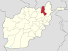 | |
|---|---|---|
| Populated Places | ||
| Other | ||
