

Size of this PNG preview of this SVG file: 800 × 377 pixels. Other resolutions: 320 × 151 pixels | 640 × 301 pixels | 1,024 × 482 pixels | 1,280 × 602 pixels | 2,560 × 1,205 pixels | 1,481 × 697 pixels.
Original file (SVG file, nominally 1,481 × 697 pixels, file size: 15 KB)
| This is a file from the Wikimedia Commons. Information from its description page there is shown below. Commons is a freely licensed media file repository. You can help. |
Summary
| Description |
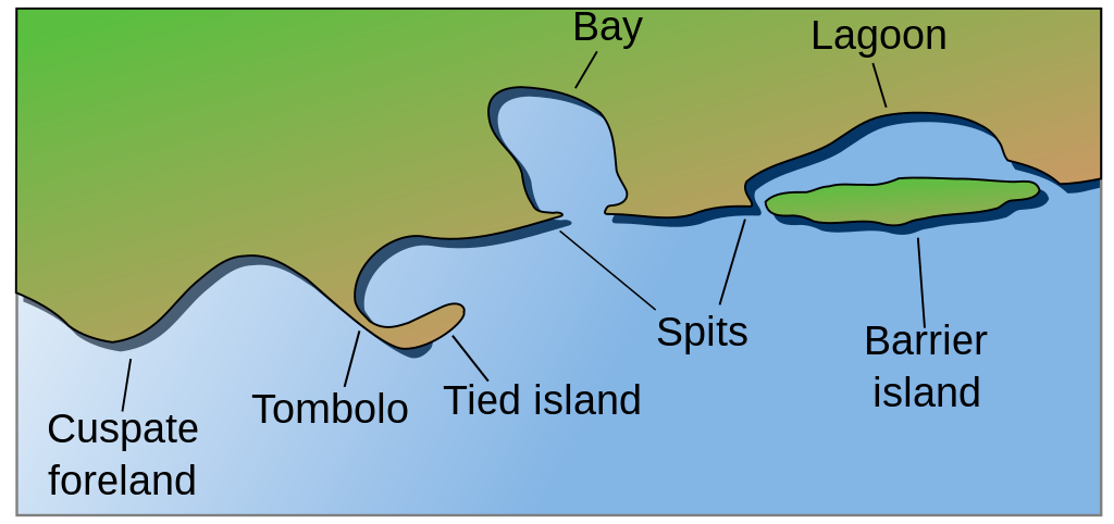
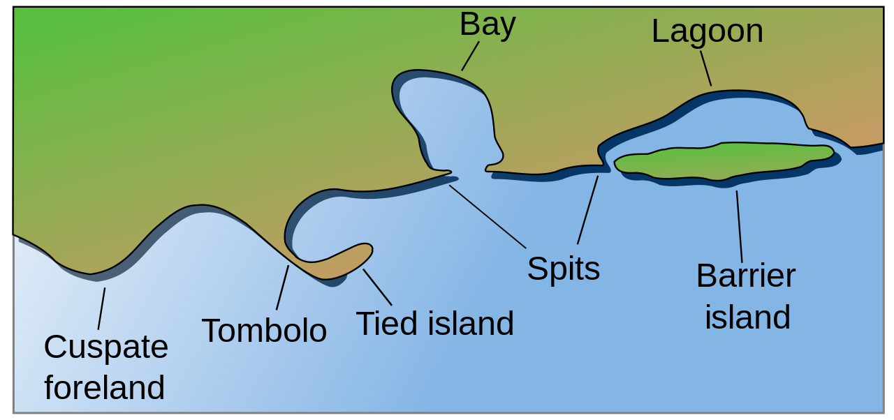
Coastal and oceanic landforms. Cuspate foreland, tombolo, spit, bay, lagoon, barrier island. |
| Date | |
| Source | self-made SVG, based on the public domain PNG Accreting coast Image6.png by Feydey |
| Author | Surachit |
| Other versions |
Derivative works of this file: Accreting coast Image6-ta.svg
|
| SVG development |


Licensing
| This work has been released into the public domain by its author, Feydey. This applies worldwide. In some countries this may not be legally possible; if so: |
File history
Click on a date/time to view the file as it appeared at that time.
| Date/Time | Thumbnail | Dimensions | User | Comment | |
|---|---|---|---|---|---|
| current | 04:17, 16 May 2022 | | 1,481 × 697 (15 KB) | Bacon Noodles | Fixed background (water) alignment |
| 01:49, 12 February 2018 |  | 1,481 × 697 (15 KB) | Howpper | Added tied island. A Tombolo is what connects a Tied island to the mainland, so it would be exclusive to not include both features. | |
| 21:48, 16 August 2007 |  | 1,481 × 697 (13 KB) | Surachit | {{Information |Description=Coastal and oceanic landforms. Cuspate foreland, tombolo, spit, bay, lagoon, barrier island. |Source=self-made SVG, based on the public domain PNG [http://en.wikipedia.org/wiki/Image:Accreting_coast_Image6.png] by [http://en.wik |
File usage
More than 100 pages use this file. The following list shows the first 100 pages that use this file only. A full list is available.
- Accretion (coastal management)
- Archipelago
- Atoll
- Ayre (landform)
- Ballona Wetlands
- Barrier island
- Bay
- Beach
- Beach cusps
- Beach evolution
- Beach house
- Beach nourishment
- Beach ridge
- Beachrock
- Bight (geography)
- Blowhole (geology)
- Bodden
- Boulder
- Breaking wave
- Bulkhead line
- Cape (geography)
- Channel (geography)
- Cliff
- Cliff-top dune
- Coast
- Coastal engineering
- Coastal erosion
- Coastal geography
- Coastal management
- Coastal morphodynamics
- Coastal plain
- Coastal waterfall
- Concordant coastline
- Continental margin
- Continental shelf
- Coral reef
- Cove
- Cuspate foreland
- Debouch
- Discordant coastline
- Dune
- Emergent coastline
- Estuary
- Firth
- Fjord
- Geo (landform)
- Groyne
- Gulf of California
- Inlet
- Integrated coastal zone management
- Intertidal zone
- Island
- Islet
- Isthmus
- Lagoon
- List of peninsulas
- Littoral zone
- Longshore drift
- Machair
- Marine architecture
- Marine regression
- Marine transgression
- Mudflat
- Natural arch
- New York–New Jersey Harbor Estuary
- Pebble
- Pocket beach
- Raised beach
- Reef
- Region of freshwater influence
- Ria
- Rip current
- River delta
- Rocky shore
- Salt marsh
- Sea cave
- Shingle beach
- Shoal
- Skerry
- Sound (geography)
- Spit (landform)
- Stack (geology)
- Storm beach
- Strait
- Strand plain
- Submarine canyon
- Submergent coastline
- Submersion (coastal management)
- Surf zone
- Surge channel
- Swash
- Tidal island
- Tidal marsh
- Tide pool
- Tombolo
- Volcanic arc
- Wave-cut platform
- Wind fetch
- Wind wave
- Wrack zone
View more links to this file.
Global file usage
The following other wikis use this file:
- Usage on ar.wikipedia.org
- Usage on az.wikipedia.org
- Usage on bh.wikipedia.org
- Usage on chr.wikipedia.org
- Usage on cs.wikipedia.org
- Usage on en.wikibooks.org
- Usage on en.wikiversity.org
- Usage on en.wiktionary.org
- Usage on es.wikipedia.org
- Usage on fa.wikipedia.org
View more global usage of this file.