

Bukit Batu is a mukim (subdivision) in Kulai District, Johor, Malaysia.[1] Bukit Batu means "Hill of Rock" in Malay. Kulai Municipal Council administer the town.
YouTube Encyclopedic
-
1/3Views:1 1178 005438
-
Indahnya Bukit Batu Putih di Samarinda, Kalimantan Timur
-
Misteri Bukit Batu Kapal
-
BUKIT BATU CHONDONG
Transcription
History
The village's legend, about hundred years ago, the tiger Kalimantan conquered and chaos this area, and Chong successfully lead a group of villagers to stop and kill the tiger. During WW2, the Japanese conquered this village; with the help of Chong, the villagers survived and successfully stopped the Japanese coming into the village.
Geography
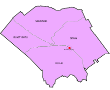
The mukim spans over an area of 86 km2.[2]
Demographics
A mainly Hakka community, the majority of the villagers have the same surname, "Chong". The mukim has 14,147 people.[3]
Economy
Most villagers are oil plantation owners, and most live in bungalows.
Transportation
Road
The town is accessible by bus from Larkin Sentral (2, 888) in Johor Bahru.[4]
References
- ^ "Latar Belakang | Portal Rasmi Majlis Perbandaran Kulai (MPK)". Archived from the original on 2017-12-29. Retrieved 2017-12-29.
- ^ Handbook johor.gov.my
- ^ Profile Archived 2020-03-31 at the Wayback Machine gov.my
- ^ "Bus Routes in Johor Bahru". BusInterchange.net. Retrieved 24 November 2017.
| |||||||||||||||
| General topics |
|  | |||||||||||||
| Administrative divisions |
| ||||||||||||||
| City councils (Majlis Bandaraya) |
| ||||||||||||||
| Municipal councils (Majlis Perbandaran) |
| ||||||||||||||
| District councils (Majlis Daerah) |
| ||||||||||||||
1°43′N 103°26′E / 1.717°N 103.433°E