
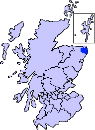
Buchan /ˈbʌxən/ is a coastal district in the north-east of Scotland, bounded by the Ythan and Deveron rivers.[1] It was one of the original provinces of the Kingdom of Alba.[2] It is now one of the six committee areas of Aberdeenshire.[3]
YouTube Encyclopedic
-
1/2Views:6 4511 057
-
The Island of Sheep 1/2 - John Buchan [Audiobook ENG]
-
Bullers o' Buchan, Aberdeenshire
Transcription
Etymology
The genesis of the name Buchan is shrouded in uncertainty,[4] but may be of Pictish origin.[4] The name may involve an equivalent of Welsh buwch meaning "a cow".[4][5] American academic Thomas Clancy has noted cautiously the similarity between the territory names Buchan and Marr to those of the Welsh commotes Cantref Bychan and Cantref Mawr, meaning "small" and "large commote" respectively.[6]
History

The first documentary record of Buchan is a reference in the Chronicle of the Kings of Alba to the death of King Indulf at the hands of Vikings in Buchan in 962, a death separately recorded in a 12th-century king-list as taking place at Cullen.[7] Cullen is to the west of the River Deveron, in an area where the Earls of Buchan held land as late as the 13th century, suggesting that Buchan's boundaries at this time extended as far west as the River Spey.[8]
In Pictish times, Buchan was located within the kingdom of Ce. There is considerable ancient history in this geographic area, especially slightly northwest of Cruden Bay, where the Catto Long Barrow and numerous tumuli are found.[9]
At one time, the district of Buchan comprised all the land between the Don and Deveron, but now the land between the Don and the Ythan is known as Formartine, so Buchan has taken on a restricted sense.[10]
Features

The Buchan area has a population of 39,160 (2001 census) and an area of 547 km2. It contains the town of Peterhead and is adjacent to the committee and administrative areas of Banff and Buchan and Formartine.
Peterhead is the largest town in Buchan and Aberdeenshire; the principal whitefish-landing port in Europe; and a major oil industry service centre. Equally important is the nearby gas terminal at St Fergus. Remote Radar Head Buchan, a RAF air defence radar unit, is located near Peterhead.
Attempts are being made to counter the negative effects of several recent key company closures and economic threats. Inland, the area is dependent upon agriculture, and many villages have seen a decline in population and services. Issues affecting Banff and Buchan also apply here, as does the future of the oil and gas industry. Part of Buchan benefits from EU aid coverage. Opportunities exist through the Buchan Local Action Plan to safeguard and enhance the economic future of Peterhead and Buchan.
The Formartine and Buchan Way runs through Buchan.
References
- ^ "Buchan". The Gazetteer for Scotland. Retrieved 4 December 2023.
- ^ MacQueen 2008, p. 287.
- ^ "Minutes of Buchan Area Committee". Aberdeenshire Council. 23 April 1996. Archived from the original on 6 June 2015. Retrieved 6 June 2015.
- ^ a b c Jackson, Kenneth (2 March 1972). The Gaelic Notes in the Book of Deer. Cambridge University Press. p. 39. ISBN 9780521082648. Retrieved 29 April 2020.
- ^ Watson, W.J.; Taylor, Simon (2011). The Celtic Place-Names of Scotland (reprint ed.). Birlinn LTD. ISBN 9781906566357.
- ^ Rhys, Guto. "Approaching the Pictish language: historiography, early evidence and the question of Pritenic" (PDF). University of Glasgow. University of Glasgow.
- ^ Woolf 2007, p. 193.
- ^ Woolf 2007, p. 194.
- ^ C. Michael Hogan. 2008. Catto Long Barrow fieldnotes, The Modern Antiquarian
- ^ Joseph Robertson, ed. (1843). Collections for a History of the Shires of Aberdeen and Banff, Volume 4.
Bibliography
- MacQueen, Hector L. (2008). "Scotland: Politics, Government and Law". In Rigby, S. H. (ed.). A Companion to Britain in the Later Middle Ages. Chichester: John Wiley & Sons. pp. 283–308. ISBN 0470998776.
- Woolf, Alex (2007). From Pictland to Alba 789–1070. Edinburgh: Edinburgh University Press. ISBN 9780748612345.
External links
- 1714 map showing Buchan
- 1745 Map showing the sheriffdom of Aberdeen (Buchan and Mar)
- 1745 Map showing the sheriffdom of Aberdeen (Buchan and Mar)
57°31′N 2°00′W / 57.52°N 2.00°W
Settlements and places of interest in Buchan, Aberdeenshire | ||
|---|---|---|
| Primary settlements |  | |
| Other settlements | ||
| Places of interest | ||
Areas and primary settlements in Aberdeenshire (see also: Aberdeen City) | ||
|---|---|---|
| in Banff and Buchan |  | |
| in Buchan | ||
| in Formartine | ||
| in Garioch | ||
| in Kincardine and Mearns | ||
| in Marr | ||
| International | |
|---|---|
| National | |