
| Gulf Fall and Uplands Australia | |||||||||||||||
|---|---|---|---|---|---|---|---|---|---|---|---|---|---|---|---|
 The interim Australian bioregions, with Gulf Fall and Uplands in red | |||||||||||||||
| Area | 118,479.09 km2 (45,745.0 sq mi) | ||||||||||||||
| |||||||||||||||
The Gulf Fall and Uplands, an interim Australian bioregion, is located in the Northern Territory and Queensland,[1][2] comprising 11,847,909 hectares (29,276,820 acres).[3]
Described in IBRA5.1[1] as "undulating terrain with scattered low, steep hills on Proterozoic and Palaeozoic sedimentary rocks, often overlain by lateritised Tertiary material; skeletal soils and shallow sands; Darwin box (Eucalyptus tectifica) and variable-barked bloodwood (Corymbia erythrophloia) woodland to low open woodland with spinifex understorey."
The abbreviation for the bioregion is GFU.[3]
| IBRA regions and subregions: IBRA7 | ||||
|---|---|---|---|---|
| IBRA region / subregion | IBRA code | Area | States | Location in Australia |
| Gulf Fall and Uplands | GFU | 11,847,909 hectares (29,276,820 acres) | NT / Qld | 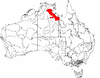
|
| McArthur | GFU01 | 9,330,938 hectares (23,057,250 acres) | ||
| Nicholson | GFU02 | 2,516,971 hectares (6,219,570 acres) | ||
See also
References
- ^ a b Environment Australia. "Revision of the Interim Biogeographic Regionalisation for Australia (IBRA) and Development of Version 5.1 - Summary Report". Department of the Environment and Water Resources, Australian Government. Archived from the original on 5 September 2006. Retrieved 31 January 2007.
- ^ IBRA Version 6.1 data
- ^ a b "Interim Biogeographic Regionalisation for Australia (IBRA7) regions and codes". Department of Sustainability, Environment, Water, Population and Communities. Commonwealth of Australia. 2012. Retrieved 13 January 2013.
Further reading
- Thackway, R and I D Cresswell (1995) An interim biogeographic regionalisation for Australia : a framework for setting priorities in the National Reserves System Cooperative Program Version 4.0 Canberra : Australian Nature Conservation Agency, Reserve Systems Unit, 1995. ISBN 0-642-21371-2
| Topics | ||
|---|---|---|
| Regions | ||
| Major settlements | ||
| General | |||||
|---|---|---|---|---|---|
| Politics and Government |
| ||||
| Regions | |||||
| Cities and towns | |||||
| People | |||||
This Northern Territory geography article is a stub. You can help Wikipedia by expanding it. |
This Queensland location article is a stub. You can help Wikipedia by expanding it. |