

Размер этого предпросмотра: 750 × 600 пкс. Другие разрешения: 300 × 240 пкс | 600 × 480 пкс | 960 × 768 пкс | 1280 × 1024 пкс | 2560 × 2048 пкс | 5000 × 4000 пкс.
Исходный файл (5000 × 4000 пкс, размер файла: 1,17 Мб, MIME-тип: image/jpeg)
Этот файл находится на Викискладе. Сведения о нём показаны ниже.
Викисклад — централизованное хранилище для свободных файлов, используемых в проектах Викимедиа.
|
Краткое описание
| Описание |
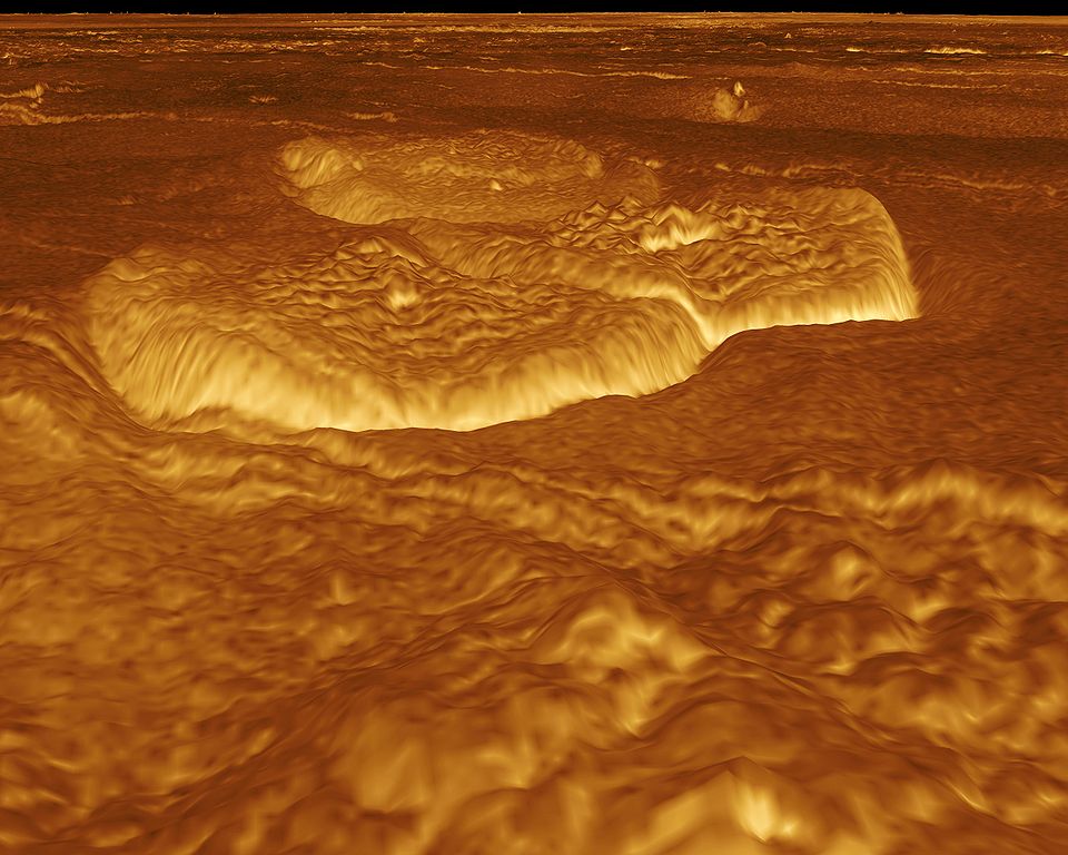
English: A portion of the eastern edge of Alpha Regio is displayed in this three-dimensional perspective view of the surface of Venus. The viewpoint is located at approximately 30 degrees south latitude, 11.8 degrees east longitude at an elevation of 2.4 kilometers (3.8 miles). The view is to the northeast at the center of an area containing seven circular dome-like hills. The average diameter of the hills is 25 kilometers (15 miles) with maximum heights of 750 meters (2,475 feet). Three of the hills are visible in the center of the image. Fractures on the surrounding plains are both older and younger than the domes. The hills may be the result of viscous or thick eruptions of lava coming from a vent on the relatively level ground, allowing the lava to flow in an even lateral pattern. The concentric and radial fracture patterns on their surfaces suggests that a chilled outer layer formed, then further intrusion in the interior stretched the surface. An alternative interpretation is that domes are the result of shallow intrusions of molten lava, causing the surface to rise. If they are intrusive, then magma withdrawal near the end of the eruptions produced the fractures. The bright margins possibly indicate the presence of rock debris or talus at the slopes of the domes. Resolution of the Magellan data is about 120 meters (400 feet). Magellan's synthetic aperture radar is combined with radar altimetry to develop a three-dimensional map of the surface. A perspective view is then generated from the map. Simulated color and a process called radar-clinometry are used to enhance small-scale structures. The simulated hues are based on color images recorded by the Soviet Venera 13 and 14 spacecraft. The image was produced by the JPL Multimission Image Processing Laboratory by Eric De Jong, Jeff Hall, Myche McAuley, and Randy Kirk of the United States Geological Survey, and is a single frame from the movie released at the May 29, 1991 Magellan news conference.
Čeština: Útvary na planetě Venuši, východně od Alpha Regio. Obraz byl vytvořen v laboratoři JPL Multimission Image Processing Laboratory, autory jsou Eric De Jong, Jeff Hall, Myche McAuley a Randy Kirk. Obraz byl získán metodou radarové klinometrie (měření sklonu) a je vyobrazen v nepravých barvách. |
| Дата | |
| Источник | http://photojournal.jpl.nasa.gov/catalog/PIA00246 |
| Автор | NASA, JPL Multimission Image Processing Laboratory, U.S Geological Survey |
| Права (Повторное использование этого файла) |
http://nssdc.gsfc.nasa.gov/photo_gallery/photogallery-faq.html#use |
Это изображение или видеозапись внесены в каталог Лаборатории реактивного движения НАСА под идентификатором (Photo ID): PIA00246. Этот шаблон не указывает на правовой статус данной работы. По-прежнему необходим нормальный шаблон лицензий. См. Commons:Лицензирование. Другие языки:
|
Лицензирование
| Этот файл находится в общественном достоянии (англ. public domain), так как он был создан NASA (Национальным управлением по аэронавтике и исследованию космического пространства). Политика авторского права NASA гласит, что «Материал NASA не защищается авторским правом, если не указано иное». (См. Template:PD-USGov, страницу политики авторского права NASA или политику использования изображений JPL.) | ||
 |
Предупреждения:
|
История файла
Нажмите на дату/время, чтобы посмотреть файл, который был загружен в тот момент.
| Дата/время | Миниатюра | Размеры | Участник | Примечание | |
|---|---|---|---|---|---|
| текущий | 21:13, 1 сентября 2005 | | 5000 × 4000 (1,17 Мб) | Bricktop | larger |
| 20:30, 1 сентября 2005 |  | 645 × 516 (45 Кб) | Lotse | *'''Original Caption Released with Image:''' A portion of the eastern edge of Alpha Regio is displayed in this three-dimensional perspective view of the surface of Venus. The viewpoint is located at approximately 30 degrees south latitude, 11.8 degrees e |
Использование файла
Следующие 3 страницы используют этот файл:
Глобальное использование файла
Данный файл используется в следующих вики:
- Использование в ar.wikipedia.org
- Использование в ca.wikipedia.org
- Использование в cs.wikipedia.org
- Использование в de.wikipedia.org
- Использование в en.wikipedia.org
- Использование в en.wikiversity.org
- Использование в fr.wikipedia.org
- Использование в hy.wikipedia.org
- Использование в ja.wikipedia.org
- Использование в mk.wikipedia.org
- Использование в nl.wikipedia.org
- Использование в pl.wiktionary.org
- Использование в uk.wikipedia.org
- Использование в zh.wikipedia.org