

Исходный файл (750 × 750 пкс, размер файла: 111 Кб, MIME-тип: image/jpeg)
Этот файл находится на Викискладе. Сведения о нём показаны ниже.
Викисклад — централизованное хранилище для свободных файлов, используемых в проектах Викимедиа.
|
Краткое описание
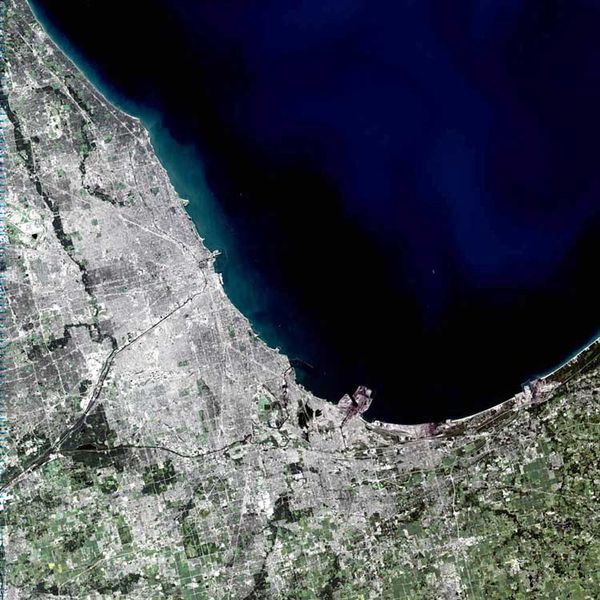
Despite being named after the Algonquian word for skunk, Chicago is one of America’s most thriving and spectacular cities. Spanning 22 miles along the southwest shore of Lake Michigan, the city itself holds nearly 2.9 million people and sits in the center of a metropolitan area containing more than 8 million.
Looking at the image, some of Chicago’s famous sites can be made out. The long black line coming into the center of the city from the southwest is the Chicago Sanitary and Ship Canal. In the center of the city, just right of where the canal banks north to become the Chicago River, sits a small pier on Lake Michigan, perpendicular to the city, known as Meigs Field. Just to the left of the pier is Soldier Field. Scanning north of Meigs Field, another pier juts out onto the lake. This is Navy Pier. Though it cannot be made out in the image, the Water Tower District and the John Hancock Building sit between Navy Pier and the Chicago River. South of this area is downtown Chicago and the Sears Tower.
This simulated-color scene was acquired by the Landsat 7 Enhanced Thematic Mapper plus (ETM+) on September 14, 2001.
Image courtesy Ron Beck, USGS Land Processes Data Center, Satellite Systems Branch
SOURCE: http://earthobservatory.nasa.gov/Newsroom/NewImages/images.php3?img_id=11277
”The purpose of NASA's Earth Observatory is to provide a freely-accessible publication on the Internet where the public can obtain new satellite imagery and scientific information about our home planet. The focus is on Earth's climate and environmental change. In particular, we hope our site is useful to public media and educators. Any and all materials published on the Earth Observatory are freely available for re-publication or re-use, except where copyright is indicated. We ask that NASA's Earth Observatory be given credit for its original materials.”
Picture prepared for Wikipedia by Adrian Pingstone in November 2003.
Uploaded to en: by en:User:Arpingstone on November 8, 2003
| Этот файл находится в общественном достоянии (англ. public domain), так как он был создан NASA (Национальным управлением по аэронавтике и исследованию космического пространства). Политика авторского права NASA гласит, что «Материал NASA не защищается авторским правом, если не указано иное». (См. Template:PD-USGov, страницу политики авторского права NASA или политику использования изображений JPL.) | ||
 |
Предупреждения:
|
en:Image:Chicago.landsat.750pix.jpg
История файла
Нажмите на дату/время, чтобы посмотреть файл, который был загружен в тот момент.
| Дата/время | Миниатюра | Размеры | Участник | Примечание | |
|---|---|---|---|---|---|
| текущий | 20:02, 17 апреля 2005 | | 750 × 750 (111 Кб) | Dubaduba~commonswiki | Category:Chicago from wikipedia |
Использование файла
Следующая страница использует этот файл:
Глобальное использование файла
Данный файл используется в следующих вики:
- Использование в af.wikipedia.org
- Использование в als.wikipedia.org
- Использование в ar.wikipedia.org
- Использование в br.wikipedia.org
- Использование в ceb.wikipedia.org
- Использование в cy.wikipedia.org
- Использование в en.wikipedia.org
- Chicago
- Gary, Indiana
- Zion, Illinois
- Will County, Illinois
- Kenosha County, Wisconsin
- Porter County, Indiana
- Newton County, Indiana
- LaPorte County, Indiana
- Lake County, Indiana
- Jasper County, Indiana
- McHenry County, Illinois
- Lake County, Illinois
- LaSalle County, Illinois
- Kendall County, Illinois
- Kankakee County, Illinois
- Kane County, Illinois
- Grundy County, Illinois
- DuPage County, Illinois
- DeKalb County, Illinois
- Cook County, Illinois
- Boone County, Illinois
- Evanston, Illinois
- Belvidere, Illinois
- Alsip, Illinois
- Arlington Heights, Illinois
- Barrington, Illinois
- Barrington Hills, Illinois
- Bartlett, Illinois
- Bedford Park, Illinois
- Bellwood, Illinois
- Bensenville, Illinois
- Berkeley, Illinois
- Berwyn, Illinois
- Blue Island, Illinois
- Bridgeview, Illinois
- Broadview, Illinois
- Brookfield, Illinois
- Buffalo Grove, Illinois
- Burbank, Illinois
- Burnham, Illinois
- Burr Ridge, Illinois
- Calumet City, Illinois
- Calumet Park, Illinois
Просмотреть глобальное использование этого файла.