
Исходный файл (2598 × 2039 пкс, размер файла: 1,61 Мб, MIME-тип: image/jpeg)
Этот файл находится на Викискладе. Сведения о нём показаны ниже.
Викисклад — централизованное хранилище для свободных файлов, используемых в проектах Викимедиа.
|
Краткое описание
| Описание |
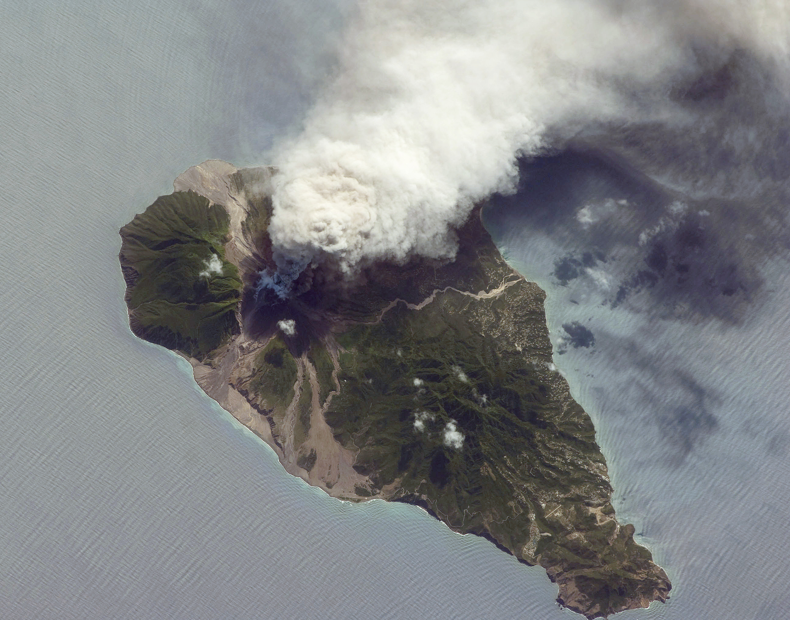
English: This oblique astronaut photograph from the International Space Station (ISS) captures a white-to-grey ash and steam plume extending westwards from the volcano. Oblique images are taken by astronauts looking out from the ISS at an angle, rather than looking straight downward toward the Earth (a perspective called a nadir view), as is common with most remotely sensed data from satellites. An oblique view gives the scene a more three-dimension quality, and provides a look at the vertical structure of the volcanic plume. While much of the island is covered in green vegetation, grey deposits that include pyroclastic flows and volcanic mud-flows (lahars) are visible extending from the volcano toward the coastline. When compared to its extent in earlier views, the volcanic debris has filled in more of the eastern coastline. Urban areas are visible in the northern and western portions of the island; they are recognizable by linear street patterns and the presence of bright building rooftops. The silver-grey appearance of the Caribbean Sea surface is due to sun-glint, which is the mirror-like reflection of sunlight off the water surface back towards the hand-held camera on-board the ISS. The sun-glint highlights surface wave patterns around the island.
|
||||||||||||||||||||||||||||||||||||||||||||||||||||||
| Дата | |||||||||||||||||||||||||||||||||||||||||||||||||||||||
| Источник | NASA Earth Observatory | ||||||||||||||||||||||||||||||||||||||||||||||||||||||
| Автор | Image taken by the NASA Expedition 21 crew | ||||||||||||||||||||||||||||||||||||||||||||||||||||||
| Местоположение камеры | | Это и другие изображения по их местоположению на OpenStreetMap |
|---|
Это изображение или видеозапись внесены в каталог Космического центра имени Джонсона НАСА под идентификатором (Photo ID): ISS021-E-5555. Этот шаблон не указывает на правовой статус данной работы. По-прежнему необходим нормальный шаблон лицензий. См. Commons:Лицензирование. Другие языки:
|
Image acquired with a Nikon D2Xs digital camera fitted with a 400 mm lens, and is provided by the ISS Crew Earth Observations experiment and Image Science & Analysis Laboratory, Johnson Space Centre.
Лицензирование
| Этот файл находится в общественном достоянии (англ. public domain), так как он был создан NASA (Национальным управлением по аэронавтике и исследованию космического пространства). Политика авторского права NASA гласит, что «Материал NASA не защищается авторским правом, если не указано иное». (См. Template:PD-USGov, страницу политики авторского права NASA или политику использования изображений JPL.) | ||
 |
Предупреждения:
|
История файла
Нажмите на дату/время, чтобы посмотреть файл, который был загружен в тот момент.
| Дата/время | Миниатюра | Размеры | Участник | Примечание | |
|---|---|---|---|---|---|
| текущий | 10:26, 19 октября 2009 | | 2598 × 2039 (1,61 Мб) | Originalwana | {{Information |Description={{en|1=This oblique astronaut photograph from the International Space Station (ISS) captures a white-to-grey ash and steam plume extending westwards from the |
Использование файла
Следующая страница использует этот файл:
Глобальное использование файла
Данный файл используется в следующих вики:
- Использование в de.wikipedia.org
- Использование в el.wikipedia.org
- Использование в en.wikiversity.org
- User:Marshallsumter/Radiation astronomy1/Planets/Sciences
- Draft:Keynote lectures/Satellites for radiation astronomy
- Draft:Original research/Astrogeology
- Planets/Geology
- User:Marshallsumter/Radiation astronomy2/Rocks
- Gases/Gaseous objects/Earth
- Radiation/Astronomy
- User:Marshallsumter/Radiation astronomy2/Satellites
- User:Marshallsumter/Radiation astronomy2/Reflections
- User:Marshallsumter/Radiation astronomy/Earth
- Orbital platforms
- Использование в fr.wikipedia.org
- Использование в hy.wikipedia.org
- Использование в no.wikipedia.org
- Использование в oc.wikipedia.org