
| Strausberg | ||
|---|---|---|
| Entidad subnacional | ||
 | ||
 Escudo | ||
 Strausberg Localización de Strausberg en Alemania | ||
 | ||
| Coordenadas | 52°34′51″N 13°52′53″E / 52.580833333333, 13.881388888889 | |
| Idioma oficial | Alemán | |
| Entidad | Medium-sized district town y Municipio urbano de Alemania | |
| • País | Alemania | |
| • Estado federado | Brandemburgo | |
| • Distrito | Märkisch-Oderland | |
| Dirigentes | ||
| • Alcalde | Elke Stadeler | |
| Superficie | ||
| • Total | 67.86 km² | |
| Altitud | ||
| • Media | 94 m s. n. m. | |
| Población (2010-12-31) | ||
| • Total | 26,206 hab. | |
| • Densidad | 402,47 hab./km² | |
| Huso horario | CET (UTC +1) | |
| • en verano | CEST (UTC +2) | |
| Código postal | 15344[1] | |
| Prefijo telefónico | 03341 | |
| Matrícula | MOL | |
| Número oficial de comunidad | 12064472 | |
| Sitio web oficial | ||
Strausberg es una ciudad de Brandeburgo (Alemania), centro mayor del "landkreis" Märkisch-Oderland. Su distancia al centro de Berlín es de 30 km, y también 30 km hasta Kostrzyn nad Odrą, en la frontera con Polonia.
YouTube Encyclopedic
-
1/3Views:2 42311 0081 121
-
19960606 S5 Strausberg - Strausberg Stadt
-
Fanfarenzug Strausberg
-
Strausberg Straßenbahn Strausberg Tramway Strausberg ⇒ Lustgarten
Transcription
Historia
Strausberg fue fundado alrededor de 1240 y en 1333 su primer pasillo de ciudad fue construido. Una pared defensiva histórica confina hoy la vieja ciudad. La ciudad era el asiento administrativo del distrito de Strausberg hasta una fusión (1993) con Bad Freienwalde y Seelow formó el "Märkisch-Oderland", con Seelow que se convertía en el nuevo asiento administravtive del distrito.
Geografía
Strausberg se localiza 30 km al este de Berlín y de 30 (oeste) de la frontera polaca de Kostrzyn.
La ciudad tiene 3 pedanías (Ortsteile): Gladowshöhe, Hohenstein y Ruhlsdorf.
Demografía
-
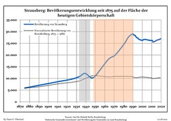 Tendencia poblacionales desde 1875 (línea azul: población; línea punteada: comparación con tendencias poblacionales del estado de Brandenburg; fondo gris: tiempo de gobierno Nazi; fondo rojo: tiempo de Gobierno comunista)
 -
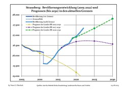 Proyecciones y desarrollo poblacional reciente (Desarrollo poblacional antes del censo del 2011 (línea azul); Desarrollo poblacional reciente de acuerdo al Censo en Alemania del 2011 (línea azul con bordes); Proyecciones ofiales para el período 2005-2030 (línea amarilla); para el período 2017-2030 (línea escarlata); para el período 2020-2030 (línea verde)


| Strausberg: Desarrollo poblacional[2] | ||||||||||||||||||||||||||||||||||||||||||||||||||||||||||||||||||||||||||
|---|---|---|---|---|---|---|---|---|---|---|---|---|---|---|---|---|---|---|---|---|---|---|---|---|---|---|---|---|---|---|---|---|---|---|---|---|---|---|---|---|---|---|---|---|---|---|---|---|---|---|---|---|---|---|---|---|---|---|---|---|---|---|---|---|---|---|---|---|---|---|---|---|---|---|
|
|
| ||||||||||||||||||||||||||||||||||||||||||||||||||||||||||||||||||||||||
Personalidades
- Andreas Angelus (1561-1598)
- Johannes Haw (1871-1949)
- Georg Kurtze (19??-1945)
- Gertrud Rossner (1903-1984)
- Sigmund Jähn (1937)
- Michael Gartenschläger (1944-1976)
Ciudades hermanadas
 Dębno - Polonia
 Frankenthal - Alemannia
 Terezín - R.Checa
Galería de imágenes
-
 Panorama
 -
 Centro histórico
 -
 Antiguas paredes de la ciudad
 -
 Tranvía
Otros proyectos
 Wikimedia Commons alberga una categoría multimedia sobre Strausberg.
Referencias
- ↑ Worldpostalcodes.org, código postal n.º 15344.
- ↑ Las fuentes de datos detalladas pueden ser encontradas en Wikimedia Commons.Population Projection Brandenburg at Wikimedia Commons
Enlaces externos
- Strausberg
- Stadt Strausberg
- Strausberg-Live
- FC Strausberg
- Strausberger Eisenbahn (tram urbano)
- Stadtwiki Strausberg
- Mapa de los ferrocarriles urbanos (www.urbanrail.net)
 Datos: Q490521
- Multimedia: Strausberg / Q490521