
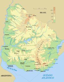
Sierra Carapé o Sierra de Carapé es una cordillera ubicada en el Departamento de Maldonado, al sur de Uruguay. Esta cordillera cruza el Departamento de Maldonado de oeste a este y entra en el Departamento de Rocha. Además constituye la frontera entre los departamentos de Lavalleja y Maldonado. En idioma guaraní, carapé significa "petiso" o de baja estatura.

Es uno de los ramales de la Cuchilla Grande. Esta cordillera posee el punto más alto de Uruguay, el Cerro Catedral, con 513,66 m s. n. m. Se ubica en las coordenadas 34°20′00″S 54°39′00″O / -34.33333, -54.65000.
Galería
-
 Camino al Cerro Catedral (también llamado Cerro Cordillera), punto más alto de Uruguay (513,66 msnm).
 -
 La cumbre del Cerro Catedral.
 -
 Una cumbre rocosa de la Sierra Carapé.
Véase también
Referencias
Enlaces externos
- (en español) Cerro Catedral, Sitio de la Municipalidad de Maldonado, Uruguay.
- (en inglés) Peakbagger.com: Cerro Catedral, Uruguay
| Control de autoridades |
|
|---|
 Datos: Q586928
 Multimedia: Sierra Carapé / Q586928