To install click the Add extension button. That's it.

The source code for the WIKI 2 extension is being checked by specialists of the Mozilla Foundation, Google, and Apple. You could also do it yourself at any point in time.

4,5
Kelly Slayton
Congratulations on this excellent venture… what a great idea!
Alexander Grigorievskiy
I use WIKI 2 every day and almost forgot how the original Wikipedia looks like.
Live Statistics
Spanish Articles
Improved in 24 Hours
Added in 24 Hours
What we do. Every page goes through several hundred of perfecting techniques; in live mode. Quite the same Wikipedia. Just better.
.
Leo
Newton
Brights
Milds

De Wikipedia, la enciclopedia libre

Maxvorstadt
Entidad subnacional


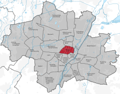
Ubicación de Maxvorstadt
Coordenadas 48°09′00″N 11°34′10″E / 48.15, 11.569444444444
Entidad Borough of Munich y Barrio
 • País
Bandera de Alemania
 
Alemania
Superficie  
 • Total 4,3 km² Ver y modificar los datos en Wikidata
Población (31 de diciembre de 2016)  
 • Total 53 443 hab.
 • Densidad 12 428,6 hab/km²
Código postal 80333, 80335, 80539, 80636 y 80797
Prefijo telefónico 089
Sitio web oficial 
Mapa de Maxvorstadt.

Maxvorstadt es un barrio del centro de Múnich (Alemania) que constituye el distrito 3 Maxvorstadt. Desde 1992, este barrio incluye los antiguos barrios 5, 6 y 7 (Maxvorstadt-Universität, Maxvorstadt-Königsplatz-Marsfeld y Maxvorstadt-Josephsplatz).

Localización

El barrio se encuentra junto a la parte noroeste del centro histórico. El Jardín Inglés constituye su límite por el este, Schwabing está al norte, y Neuhausen-Nymphenburg al noroeste. Limita con el barrio de Schwanthalerhöhe por el suroeste y con Ludwigsvorstadt-Isarvorstadt por el sur. La zona este de Maxvorstadt a menudo se atribuye erróneamente al barrio de Schwabing.[1]

Tráfico

Maxvorstadt tiene un plan hipodámico y está delimitado por los ejes norte-sur Schleißheimer Straße y Ludwigstraße; las calles paralelas Amalienstraße, Türkenstraße, Barer Straße, Schraudolphstraße, Arcisstraße, Luisenstraße y Augustenstraße discurren entre ellas. Estas dos calles principales están conectadas entre sí por las calles este-oeste Gabelsbergerstraße, Theresienstraße, Heßstraße, Schellingstraße, Zieblandstraße, Görresstraße y Georgenstraße. Theresienstraße y Gabelsbergerstraße son calles de un solo sentido.

Se puede llegar a Maxvorstadt en transporte público mediante las estaciones Königsplatz, Theresienstraße y Josephsplatz de la línea U2 del Metro de Múnich, la estación Universität de las líneas U3 y U6, y la estación Stiglmaierplatz de la línea U1. Además, pasan por el barrio las líneas de tranvía 16, 17, 20, 21, 27 y 28, así como varias líneas de autobuses.

Lugares de interés

La Ludwigstraße en Maxvorstadt.
  • 8. November 1939 (memorial)
  • Abadía de San Bonifacio
  • Academia de Bellas Artes de Múnich
  • Akademiegalerie
  • Alter Botanischer Garten
  • Alter Nordfriedhof
  • Altstadtring
  • Altstadtringtunnel
  • Consulado General de los Estados Unidos en Múnich
  • Museo de Arquitectura de la Universidad Técnica de Múnich
  • Arnold & Richter Cine Technik
  • Augenklinik Herzog Carl Theodor
  • Estación de Múnich Hackerbrücke
  • Cancillería Estatal de Baviera
  • Ministerio de Guerra de Baviera
  • Bennosäule
  • Bernheimer-Haus
  • Casa Parda
  • Distrito electoral Múnich-Norte
  • Dachauer Straße
  • Fuente de los Delfines
  • Monumento a Franz Xaver Gabelsberger
  • Dichtergarten
  • Die Neue Sammlung
  • Königliche Erzgießerei in München
  • Führerbau
  • Gabriel Filmtheater
  • Museo Geológico de Múnich
  • Glaspalast
  • Hackerbrücke
  • Harmlos
  • Hochschule für Musik und Theater München
  • Hochschule für Philosophie München
  • Hochschule für Politik München
  • Hofbrunnwerkkanal
  • Hofgartenkaserne
  • Institut français
  • Palacio de Justicia de Múnich
  • Kaim-Saal
  • Karstadt München Bahnhofplatz
  • Kleines Spiel
  • Königliche Kunstgewerbeschule München
  • Königsplatz
  • Circus Krone
  • Kronebau
  • Kunstsammlung des Herzoglichen Georgianums
  • Landeskirchenamt München
  • Lenbachplatz
  • Löwenbräukeller
  • Maillingerstraße
  • Marsfeld
  • Max-Planck-Institut für Sozialrecht und Sozialpolitik
  • Münchner Haus der Kulturinstitute
  • Münchner Theater für Kinder
  • Museum für Abgüsse Klassischer Bildwerke
  • Fuente de Neptuno
  • Nornenbrunnen
  • Centro de documentación sobre la historia del nacionalsocialismo
  • Odeón
  • Odeonsplatz
  • Erich Ott
  • Prinz-Carl-Palais
  • Propileos
  • Richard-Wagner-Straße
  • Rundfunkplatz
  • Salzstadelkaserne
  • Schauspiel München
  • Schelling-Salon
  • Schleißheimer Straße
  • Siegestor
  • SiemensForum München
  • Simpl
  • SportA
  • SDI Múnich
  • Iglesia de San Benno
  • Iglesia de San José
  • Iglesia de San Marco
  • St.-Benno-Viertel
  • Staatliche Antikensammlungen
  • Staatsarchiv München
  • Lenbachhaus
  • Städtisches Luisengymnasium München
  • Stimmkreis München-Schwabing
  • The Charles Hotel
  • Theater Die Kleine Freiheit
  • TheaterRaum München
  • Türkengraben
  • Türkenkaserne
  • Estación de Josephsplatz (Metro de Múnich)
  • Estación de Königsplatz (Metro de Múnich)
  • Estación de Stiglmaierplatz (Metro de Múnich)
  • Estación de Theresienstraße (Metro de Múnich)
  • Winzererstraße
  • Wittelsbacher-Gymnasium München
  • Fuente Wittelsbacher
  • Wohnhaus Reinemann
  • Wohnheimsiedlung Maßmannplatz
  • Zentraler Omnibusbahnhof München

Véase también

Referencias

  1. «Munich districts: Maxvorstadt» (en inglés). simply Múnich. Consultado el 5 de enero de 2020. 

Enlaces externos

Esta página se editó por última vez el 19 jul 2023 a las 21:15.
Basis of this page is in Wikipedia. Text is available under the CC BY-SA 3.0 Unported License. Non-text media are available under their specified licenses. Wikipedia® is a registered trademark of the Wikimedia Foundation, Inc. WIKI 2 is an independent company and has no affiliation with Wikimedia Foundation.