
| Diala ديالى Diyālā | ||||
|---|---|---|---|---|
| Gobernación | ||||
 | ||||
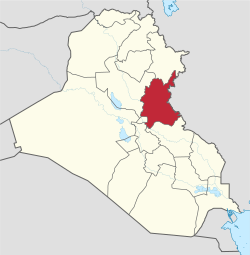 Ubicación de Diala en Irak. | ||||
| Coordenadas | 33°53′00″N 45°04′00″E / 33.883333333333, 45.066666666667 | |||
| Capital | Baquba | |||
| Entidad | Gobernación | |||
| • País |
| |||
| Superficie | ||||
| • Total | 17685 km² | |||
| Población (2012) | ||||
| • Total | 1 443 200 hab. | |||
| • Densidad | 93,27 hab./km² | |||
| Huso horario | UTC+03:00 | |||

Diala (árabe: محافظة ديالى muḥāfaẓah Diyālā) es una de las dieciocho gobernaciones que conforman la república de Irak. Su capital es Baquba. Ubicada al centro-este del país, limita al norte con Solimania, al este con Irán, al sur con Wasit, al suroeste con Babilonia y Bagdad, y al oeste con Saladino.
Territorio
Diala tiene un área de 17 685 km² y, según datos de 2012, una población estimada de 1 443 200 habs., en su mayor parte árabes sunníes y kurdos. El río Diala, un afluente importante del Tigris, proporciona agua a gran parte de la provincia.
Distritos
La provincia de Diyala se divide en seis distritos:
- Al Khalis
- Al Mokdadia
- Baquba
- Baladruz
- Khanaqin
- Kifri
 Datos: Q217075
 Multimedia: Diyala Governorate / Q217075