
| Cortemaggiore | ||
|---|---|---|
| Entidad subnacional | ||
 | ||
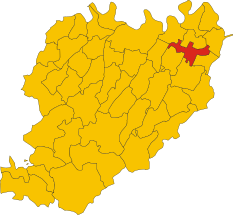
 Cortemaggiore Localización de Cortemaggiore en Italia | ||
 | ||
| Coordenadas | 45°00′00″N 9°56′00″E / 45, 9.9333333333333 | |
| Capital | Cortemaggiore | |
| Idioma oficial | Italiano | |
| Entidad | Comuna de Italia | |
| • País | Italia | |
| • Región | Emilia-Romaña | |
| • Provincia | Piacenza | |
| Fracciones | Chiavenna Landi, San Martino in Olza | |
| Municipios limítrofes | Besenzone, Cadeo, Caorso, Fiorenzuola d'Arda, Pontenure, San Pietro in Cerro, Villanova sull'Arda | |
| Superficie | ||
| • Total | 36,82 km² | |
| Altitud | ||
| • Media | 50 m s. n. m. | |
| Población (30-11-2008 (fonte Istat)) | ||
| • Total | 4,479 hab. | |
| • Densidad | 123 hab./km² | |
| Gentilicio | Cortemaggioresi (o anche magiostrini, aggettivo di uso dialettale) | |
| Huso horario | CET (UTC +1) | |
| • en verano | CEST (UTC +2) | |
| Código postal | 29016[1] | |
| Prefijo telefónico | 0523 | |
| Matrícula | PC | |
| Código ISTAT | 033018 | |
| Código catastral | D061[2] | |
| Fiestas mayores | 10 de agosto | |
| Patrono(a) | Lorenzo | |
| Sitio web oficial | ||
Cortemaggiore es un municipio situado en el territorio de la Provincia de Piacenza, en Emilia-Romaña, (Italia).
YouTube Encyclopedic
-
1/2Views:6 423733
-
cortemaggiore il mercatino dell'antiquariato
-
A&S | Nuova area logistica - Cortemaggiore (PIACENZA)
Transcription
Demografía
| Gráfica de evolución demográfica de Cortemaggiore entre 1861 y 2006 |
 |
|
Fuente ISTAT - elaboración gráfica de Wikipedia |
Enlaces externos
 Datos: Q102691
 Multimedia: Cortemaggiore / Q102691
- ↑ Worldpostalcodes.org, código postal n.º 29016.
- ↑ «Codici Catastali». Comuni-italiani.it (en italiano). Consultado el 29 de abril de 2017.