
| Boitzenburger Land | ||
|---|---|---|
| Municipio | ||
 Castillo de Boitzenburger Land
| ||
 Escudo | ||
 Boitzenburger Land Ubicación de Boitzenburger Land en Brandeburgo | ||
 | ||
| Coordenadas | 53°15′39″N 13°36′27″E / 53.260888888889, 13.6075 | |
| Entidad | Municipio | |
| • País |
| |
| Superficie | ||
| • Total | 215,9 km² | |
| Altitud | ||
| • Media | 107 m s. n. m. | |
| Población (2022) | ||
| • Total | 3131 hab. | |
| • Densidad | 14,5 hab./km² | |
| Huso horario | UTC+01:00 y UTC+02:00 | |
| Código postal | 17268[1] | |
| Prefijo telefónico | 039884, 039885 y 039889 | |
| Matrícula | UM | |
| Número oficial de comunidad | 12073069 | |
| Sitio web oficial | ||
Boitzenburger Land es un municipio situado en el distrito de Uckermark, en el estado federado de Brandeburgo (Alemania), a una altura de 80 metros. Su población a finales de 2016 era de 3200 habs. y su densidad poblacional, 15 hab/km².[2]
Demografía
-
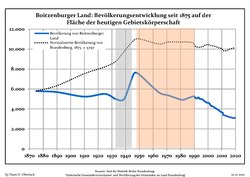 Tendencia poblacional desde 1875 (línea azul: población; línea punteada: comparación con tendencias poblacionales del estado de Brandenburg; fondo gris: tiempo de gobierno Nazi; fondo rojo: tiempo de Gobierno comunista)
 -
 Proyecciones y desarrollo poblacional reciente (Desarrollo poblacional antes del censo del 2011 (línea azul); Desarrollo poblacional reciente de acuerdo al Censo en Alemania del 2011 (línea azul con bordes); Proyecciones ofiales para el período 2005-2030 (línea amarilla); para el período 2017-2030 (línea escarlata); para el período 2020-2030 (línea verde)


| Boitzenburger Land: Desarrollo poblacional[3] | ||||||||||||||||||||||||||||||||||||||||||||||||||||||||||||||||||||||||||
|---|---|---|---|---|---|---|---|---|---|---|---|---|---|---|---|---|---|---|---|---|---|---|---|---|---|---|---|---|---|---|---|---|---|---|---|---|---|---|---|---|---|---|---|---|---|---|---|---|---|---|---|---|---|---|---|---|---|---|---|---|---|---|---|---|---|---|---|---|---|---|---|---|---|---|
|
|
| ||||||||||||||||||||||||||||||||||||||||||||||||||||||||||||||||||||||||
Referencias
- ↑ Worldpostalcodes.org, código postal n.º 17268.
- ↑ [1] Estadísticas bundestag. Consultado el 7 de junio de 2018
- ↑ Las fuentes de datos detalladas pueden ser encontradas en Wikimedia Commons.Population Projection Brandenburg at Wikimedia Commons
Enlaces externos
- Esta obra contiene una traducción derivada de «Boitzenburger Land» de Wikipedia en inglés, publicada por sus editores bajo la Licencia de documentación libre de GNU y la Licencia Creative Commons Atribución-CompartirIgual 4.0 Internacional.
 Wikimedia Commons alberga una categoría multimedia sobre Boitzenburger Land.
 Datos: Q576592
- Multimedia: Boitzenburger Land / Q576592