
No se dispone de una resolución más alta.
Vesta-Elevation.jpg (500 × 500 píxeles; tamaño de archivo: 43 kB; tipo MIME: image/jpeg)
| Descripción |
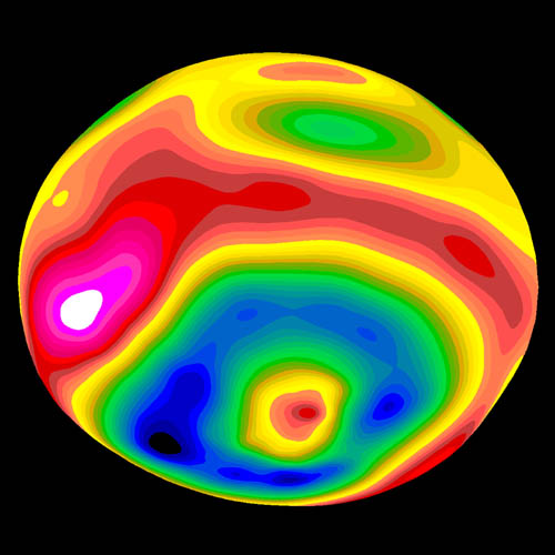
A color-encoded elevation map of Vesta clearly shows the giant 460-kilometer diameter impact basin and "bull's-eye" central peak. The map was constructed from 78 Wide Field Planetary Camera 2 pictures. Surface topography was estimated by noting irregularities along the limb and at the terminator (day/night boundary) where shadows are enhanced by the low Sun angle. Deutsch: Farbkodierte Höhenkarte von Vesta.
Polski: Mapa Westy ukazująca różnice w wysokościach na jej powierzchni |
| Fecha | Image published 1997 September 4 |
| Fuente | http://hubblesite.org/newscenter/newsdesk/archive/releases/1997/27/image/e |
| Autor | Ben Zellner (Georgia Southern University) and NASA |
| Permiso (Reutilización de este archivo) |
Unless otherwise specifically stated, no claim to copyright is being asserted by STScI and it may be freely used as in the public domain in accordance with NASA's contract. [...] [1] |
| Este archivo es de dominio público porque fue creado por la NASA. Las políticas sobre copyright de la NASA estipulan que «el material de la NASA no está protegido con copyright a menos que se indique lo contrario». (Políticas sobre copyright de la NASA o Políticas sobre la utilización de imágenes del Jet Propulsion Laboratory). | ||
 |
Advertencias:
|
Historial del archivo
Haz clic sobre una fecha y hora para ver el archivo tal como apareció en ese momento.
| Fecha y hora | Miniatura | Dimensiones | Usuario | Comentario | |
|---|---|---|---|---|---|
| actual | 07:57 30 ene 2006 | | 500 × 500 (43 kB) | Arnomane | higher resolution |
| 17:56 24 ago 2005 |  | 200 × 200 (6 kB) | <bdi>Vesta~commonswiki</bdi> | * Description: A color-encoded elevation map of Vesta clearly shows the giant 460-kilometer diameter impact basin and "bull's-eye" central peak. The map was constructed from 78 Wide Field Planetary Camera 2 pictures. Surface topography was estimated by no |
Usos del archivo
Las siguientes páginas usan este archivo:
Uso global del archivo
Las wikis siguientes utilizan este archivo:
- Uso en als.wikipedia.org
- Uso en ar.wikipedia.org
- Uso en ca.wikipedia.org
- Uso en cs.wikipedia.org
- Uso en de.wikipedia.org
- Uso en en.wikipedia.org
- Uso en eu.wikipedia.org
- Uso en fa.wikipedia.org
- Uso en fi.wikipedia.org
- Uso en fr.wikipedia.org
- Uso en ko.wikipedia.org
- Uso en lb.wikipedia.org
- Uso en mk.wikipedia.org
- Uso en oc.wikipedia.org
- Uso en pt.wikipedia.org
- Uso en ro.wikipedia.org
- Uso en simple.wikipedia.org
- Uso en sk.wikipedia.org
- Uso en sv.wikipedia.org
- Uso en uk.wikipedia.org
- Uso en www.wikidata.org
- Uso en zh.wikipedia.org