
Tamaño de esta previsualización: 674 × 599 píxeles. Otras resoluciones: 270 × 240 píxeles · 540 × 480 píxeles · 864 × 768 píxeles · 1152 × 1024 píxeles · 2117 × 1882 píxeles.
Ver la imagen en su resolución original (2117 × 1882 píxeles; tamaño de archivo: 5,54 MB; tipo MIME: image/png)
Resumen
| Descripción |
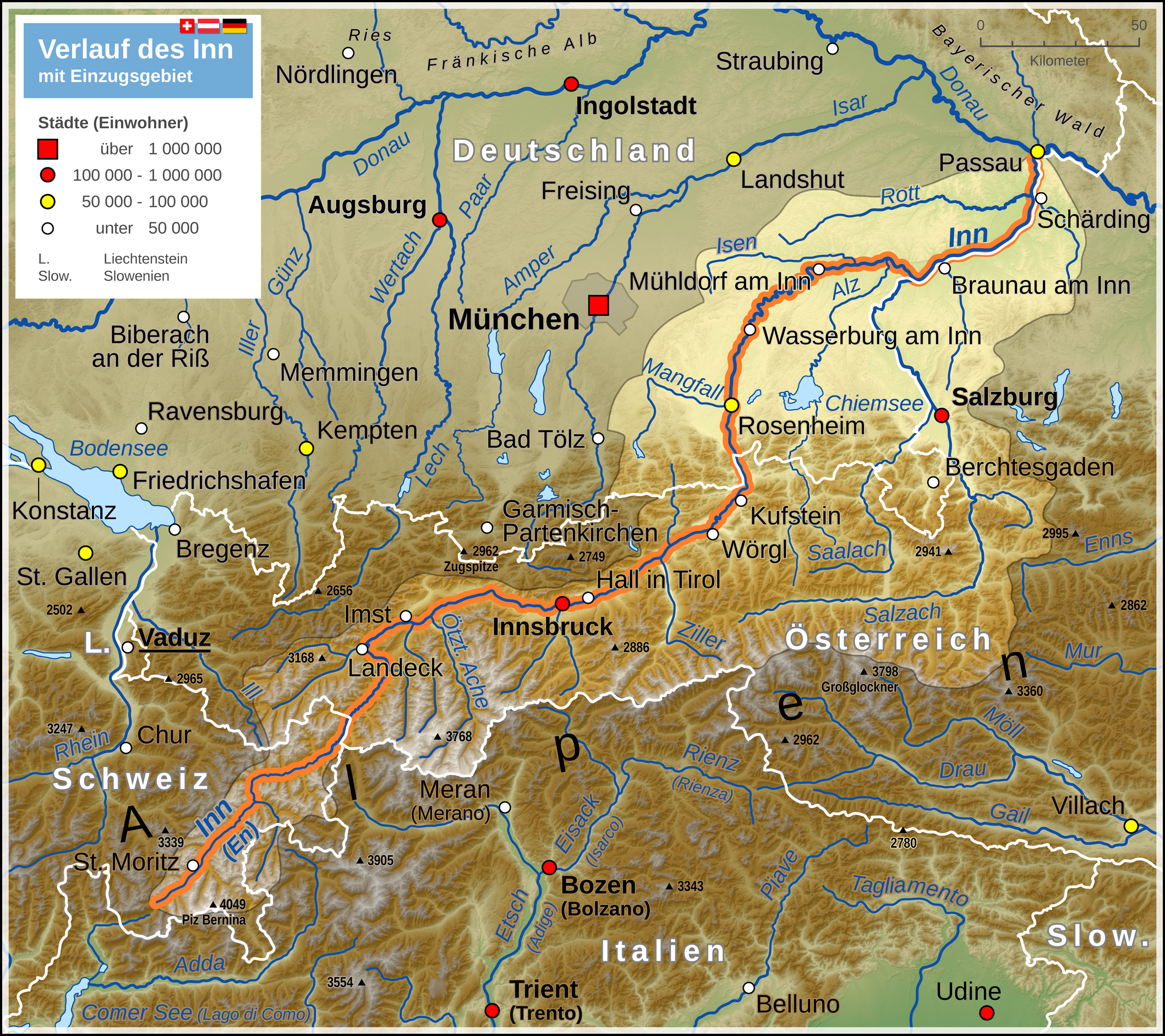
Deutsch: Verlaufskarte des Inn mit Darstellung des Einzugsgebietes
English: Map of Inn river (including drainage basin) |
| Fecha | |
| Fuente |
Trabajo propio Map created using: |
| Autor | Thoroe |
| Permiso (Reutilización de este archivo) |
Map data (c) OpenStreetMap (and) contributors, CC-BY-SA |

|
Este mapa se ha hecho o mejorado en el Kartenwerkstatt (taller cartográfico) alemán. También puede proponer mapas para mejorar.
|
Licencia
Este archivo se encuentra bajo la licencia Creative Commons Genérica de Atribución/Compartir-Igual 2.0.
Atribución: Thomas Römer/OpenStreetMap data
- Eres libre:
- de compartir – de copiar, distribuir y transmitir el trabajo
- de remezclar – de adaptar el trabajo
- Bajo las siguientes condiciones:
- atribución – Debes otorgar el crédito correspondiente, proporcionar un enlace a la licencia e indicar si realizaste algún cambio. Puedes hacerlo de cualquier manera razonable pero no de manera que sugiera que el licenciante te respalda a ti o al uso que hagas del trabajo.
- compartir igual – En caso de mezclar, transformar o modificar este trabajo, deberás distribuir el trabajo resultante bajo la misma licencia o una compatible como el original.
Historial del archivo
Haz clic sobre una fecha y hora para ver el archivo tal como apareció en ese momento.
| Fecha y hora | Miniatura | Dimensiones | Usuario | Comentario | |
|---|---|---|---|---|---|
| actual | 14:41 6 jul 2014 | | 2117 × 1882 (5,54 MB) | Thoroe | ein paar mehr Flüsse |
| 15:06 3 may 2013 |  | 2117 × 1882 (5,52 MB) | Thoroe | Einzugsgebiet korrigiert +einige Gewässer | |
| 21:24 3 ago 2012 |  | 1059 × 941 (2 MB) | Kontrollstellekundl | Das Standesamt Udine bestätigte für den 31. Januar 2012 erstmals seit 25 Jahren wieder mehr als 100.000 Einwohner - von Gelb auf Rot.<ref>http://messaggeroveneto.gelocal.it/cronaca/2012/02/03/news/udine-torna-sopra-i-100-mila-abitanti-1.3140196</... | |
| 14:48 18 oct 2011 |  | 1059 × 941 (1,88 MB) | Thoroe | farbliche Überarbeitung, Details am Einzugsgebiet | |
| 18:31 9 oct 2011 |  | 1059 × 941 (1,84 MB) | Thoroe | Einzugsgebiet, Legende reduziert, Geländehöhen, noch ein paar Nebenflüsse etc. | |
| 10:44 6 oct 2011 |  | 1059 × 941 (1,8 MB) | Thoroe | mehr Orte und diverse Änderungen | |
| 14:19 1 oct 2011 |  | 1059 × 941 (1,78 MB) | Thoroe | {{Information |Description ={{de|1=Verlauf des Inn}} |Source ={{own}} Map created using: *[http://gmt.soest.hawaii.edu Generic Mapping Tools (GMT)] with SRTM3 V2 data *[http://www.openstreetmap.org OpenStreetMap] data *[[:File:Flag |
Usos del archivo
Las siguientes páginas usan este archivo:
Uso global del archivo
Las wikis siguientes utilizan este archivo:
- Uso en af.wikipedia.org
- Uso en als.wikipedia.org
- Uso en an.wikipedia.org
- Uso en bg.wikipedia.org
- Uso en bs.wikipedia.org
- Uso en cs.wikipedia.org
- Uso en da.wikipedia.org
- Uso en de.wikipedia.org
- Uso en el.wikipedia.org
- Uso en en.wikipedia.org
- Uso en eo.wikipedia.org
- Uso en frr.wikipedia.org
- Uso en fr.wikipedia.org
- Uso en he.wikipedia.org
- Uso en hr.wikipedia.org
- Uso en hu.wikipedia.org
- Uso en hy.wikipedia.org
- Uso en incubator.wikimedia.org
- Uso en it.wikipedia.org
- Uso en ja.wikipedia.org
- Uso en ka.wikipedia.org
- Uso en ko.wikipedia.org
- Uso en lld.wikipedia.org
- Uso en mk.wikipedia.org
- Uso en ml.wikipedia.org
- Uso en nl.wikipedia.org
- Uso en nn.wikipedia.org
- Uso en no.wikipedia.org
- Uso en pl.wikipedia.org
- Uso en pl.wiktionary.org
- Uso en pnb.wikipedia.org
- Uso en rm.wikipedia.org
- Uso en ru.wikipedia.org
- Uso en sco.wikipedia.org
- Uso en sh.wikipedia.org
- Uso en sl.wikipedia.org
- Uso en sr.wikipedia.org
- Uso en sv.wikipedia.org
- Uso en tr.wikipedia.org
- Uso en vi.wikipedia.org
Ver más uso global de este archivo.