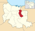
Ver la imagen en su resolución original ((Imagen SVG, nominalmente 512 × 386 pixels, tamaño de archivo: 1,46 MB))
Sumario
Resumen
![]() Este mapa SVG es parte de una serie de mapas de localización que siguen ciertas convenciones. Por favor, consulte la categoría principal para acceder a más mapas.
Este mapa SVG es parte de una serie de mapas de localización que siguen ciertas convenciones. Por favor, consulte la categoría principal para acceder a más mapas.
Locator maps design recommendations ▼ | |
|---|---|
Principles
Design Guidelines are based on ▸location map design of the German map shop (in German). It's preferable to derive new locator maps from existing location maps. Please keep both size and ratio in this case. Thus the new locator maps may still be applied as location map (▸Guide). Marker color is supposed to be darkred. Waterbodies may be transparent, to show other objects better. Please be aware that this guide is only a recommendation. It’s not an inevitable law!
Highlight small areas
“Remote” areas and mini maps
Mini maps show where the depicted area actually is situated. Check out ▸Vorlage:Positionskarte+ (in German) and ▸Modèle:Carte en coin (in French) of how to insert a mini map in virtually every map.
Disputed areas
Greyed special objects
Backgrounds
|
Map legend
- C12836 → Marked administrative territory
- FDFBEA → Marked state/province
- F6E1B9 → Other state/provinces of Venezuela
- 656564 → Lines/boundaries
Mini map legend
- C12836 → Marked state/province, and red circle
- FDFBEA → Rest of Venezuela
- DFDFDF → Other countries
- 656564 → Lines/boundaries
- C7E7FB → Water
- 000000 → Mini map border box
Geographic limits of the map (EPSG:4326)
- N: 10.6647
- S: 9.7787
- W: 68.5649
- E: 67.3906
Licencia
| DescripciónVenezuela - Carabobo - Guacara.svg |
English: Locator map of Municipio Guacara; in Carabobo, Venezuela |
|||||||||
| SVG desarrollo InfoField | El código fuente de esta imagen SVG es válido. Este mapa fue creado con Adobe Illustrator |
|||||||||
| Fecha | ||||||||||
| Fuente | OpenStreetMap data, extracted via QGIS software. | |||||||||
| Creador |
OpenStreetMap contributors |
|||||||||
| Permiso (Reutilización de este archivo) |
OpenStreetMap data is available under the Open Database License (details). Standard style map tiles are licensed as ODbL Produced Works.
|
|||||||||
| Geotemporal data | ||||||||||
| Bounding box |
|
|||||||||
| Boundaries geometry from OpenStreetMap has been simplified to optimize its indexing in Wikimedia projects. The boundaries lines shown in this image may be of lower quality than those shown in OpenStreetMap project, or in real life. |
Leyendas
Elementos representados en este archivo
representa a
Algún valor sin elemento de Wikidata
2 feb 2016
Historial del archivo
Haz clic sobre una fecha y hora para ver el archivo tal como apareció en ese momento.
| Fecha y hora | Miniatura | Dimensiones | Usuario | Comentario | |
|---|---|---|---|---|---|
| actual | 13:39 24 jul 2023 |  | 512 × 386 (1,46 MB) | Wguayana | OpenStreetMap 2023 data |
| 21:35 2 feb 2016 |  | 627 × 558 (521 kB) | Milenioscuro | User created page with UploadWizard |
Usos del archivo
Las siguientes páginas usan este archivo:
Uso global del archivo
Las wikis siguientes utilizan este archivo:
- Uso en de.wikipedia.org
- Uso en en.wikipedia.org
- Uso en fr.wikipedia.org
- Uso en it.wikipedia.org
- Uso en ka.wikipedia.org
- Uso en nl.wikipedia.org
- Uso en ro.wikipedia.org
- Uso en sv.wikipedia.org
- Uso en www.wikidata.org
- Uso en zh.wikipedia.org
Metadatos
Este archivo contiene información adicional, probablemente añadida por la cámara digital o el escáner usado para crearlo o digitalizarlo.
Si el archivo ha sido modificado desde su estado original, pueden haberse perdido algunos detalles.
| Título breve | Municipio Guacara - Carabobo - Venezuela |
|---|---|
| Anchura | 100% |
| Altura | 100% |


