

Tamaño de esta previsualización: 514 × 599 píxeles. Otras resoluciones: 206 × 240 píxeles · 412 × 480 píxeles · 659 × 768 píxeles · 878 × 1024 píxeles · 1757 × 2048 píxeles · 3675 × 4284 píxeles.
Ver la imagen en su resolución original (3675 × 4284 píxeles; tamaño de archivo: 224 kB; tipo MIME: image/png)
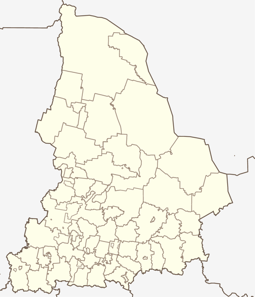
Map of Sverdlovsk Oblast, Russia, in the Mercator projection. Cropped by 1 degree lines (57° - 67° E, 56° - 62° N). Less or more suitable for PosMap.
According to the author (see Discussion:Koryakov Yuri) made on the basis of that map (Open Budget Regions of Russia project) and maps from CD "Все карты России. Ингит" (CD "Аll maps of Russia", Ingit, LLC)
Resumen
| Descripción | Map of Sverdlovskaya oblast (Russia), in the Mercator projection. |
| Fecha | |
| Fuente | self-made (based on the maps by Ingit, LLC and Open Budget Regions of Russia project) |
| Autor | Koryakov Yuri |
| Otras versiones | Obras derivadas de ésta: Sverdlovskaya-Artinsky-pozkarta.png |
Licencia
| Yo, el titular de los derechos de autor de esta obra, lo libero al dominio público. Esto aplica en todo el mundo. En algunos países esto puede no ser legalmente factible; si ello ocurriese: Concedo a cualquier persona el derecho de usar este trabajo para cualquier propósito, sin ningún tipo de condición al menos que éstas sean requeridas por la ley. |
Historial del archivo
Haz clic sobre una fecha y hora para ver el archivo tal como apareció en ese momento.
| Fecha y hora | Miniatura | Dimensiones | Usuario | Comentario | |
|---|---|---|---|---|---|
| actual | 12:05 17 sep 2019 | | 3675 × 4284 (224 kB) | Вальдимар | + селище Тайожний |
| 09:51 17 sep 2019 |  | 3675 × 4284 (223 kB) | Вальдимар | підправив кордон Махньовського МО | |
| 09:00 6 sep 2019 |  | 3675 × 4284 (223 kB) | Вальдимар | Оновлено кордони міських округів | |
| 08:50 29 nov 2012 |  | 3675 × 4284 (224 kB) | <bdi>Botinko</bdi> | Границы городских округов, утвержденные в 2005-2007 годах | |
| 16:26 22 mar 2010 |  | 2237 × 2608 (71 kB) | <bdi>Const st</bdi> | убрал рамку | |
| 16:15 22 mar 2010 |  | 2237 × 2608 (56 kB) | <bdi>Const st</bdi> | цвета и линии привёл в соответствие с принятыми нормами | |
| 08:27 25 may 2007 |  | 2237 × 2608 (74 kB) | <bdi>Koryakov Yuri</bdi> | {{Information |Description= |Source=self-made |Date=May 2007 |Author= Koryakov Yuri |other_versions= }} |
Usos del archivo
Las siguientes páginas usan este archivo:
Uso global del archivo
Las wikis siguientes utilizan este archivo:
- Uso en af.wikipedia.org
- Uso en alt.wikipedia.org
- Uso en ar.wikipedia.org
- Uso en arz.wikipedia.org
- Uso en azb.wikipedia.org
- Uso en az.wikipedia.org
- Uso en ba.wikipedia.org
- Ҡалып:ПозКарта Рәсәй Свердловск өлкәһе
- Екатеринбург
- Араҡай (Свердловск өлкәһе)
- Әжеғол
- Әртә-Шиғыр
- Волчанск (Свердловск өлкәһе)
- Шәкүр (Свердловск өлкәһе)
- Аҡҡул (Свердловск өлкәһе)
- Өфө-Шигер
- Ғәйнә (Свердловск өлкәһе)
- Биш ауыл
- Рахманғол
- Үрмәкәй (Свердловск өлкәһе)
- Аҡбаш (Свердловск өлкәһе)
- Ҡуян (Свердловск өлкәһе)
- Бәйәктамаҡ
- Бикән
- Бәхмәт
- Яманйылға (Свердловск өлкәһе)
- Түбәнге Тагил
- Әртә
- Боғалыштамаҡ
- Табанлыкүл
- Һыҙғы (ауыл)
- Үрге Бәйәк
- Белембай (Свердловск өлкәһе)
- Ирбит (ҡала)
- Октябрьский (Свердловск өлкәһе)
- Мурзинка (Горноуральск ҡала округы)
- Uso en be.wikipedia.org
Ver más uso global de este archivo.