
Tamaño de esta previsualización: 799 × 271 píxeles. Otras resoluciones: 320 × 109 píxeles · 1023 × 347 píxeles.
Ver la imagen en su resolución original (1023 × 347 píxeles; tamaño de archivo: 99 kB; tipo MIME: image/jpeg)

|
This map has been uploaded by Electionworld from en.wikipedia.org to enable the |
Resumen
| Descripción |
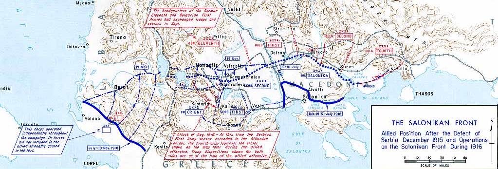
English: Operations at the border of Greece and Serbia, 1916.
his map was created by the Department of Military Art and Engineering, at the U.S. Military Academy (West Point). The initial version was created under the supervision of General Vincent Esposito in 1959. It is now available on the West Point |
||||||
| Fecha | |||||||
| Fuente | West Point | ||||||
| Autor | General Vincent Esposito | ||||||
| Permiso (Reutilización de este archivo) |
|
||||||
| Otras versiones |
  |
||||||

Historial del archivo
Haz clic sobre una fecha y hora para ver el archivo tal como apareció en ese momento.
| Fecha y hora | Miniatura | Dimensiones | Usuario | Comentario | |
|---|---|---|---|---|---|
| actual | 21:55 21 dic 2006 | 1023 × 347 (99 kB) | Electionworld | {{ew|en|Cglassey}} == Summary == Operations at the border of Greece and Serbia, 1916. his map was created by the Department of Military Art and Engineering, at the U.S. Military Academy (West Point). The initial version was created under the supervision |
Usos del archivo
La siguiente página usa este archivo:
Uso global del archivo
Las wikis siguientes utilizan este archivo:
- Uso en ar.wikipedia.org
- Uso en azb.wikipedia.org
- Uso en az.wikipedia.org
- Uso en be-tarask.wikipedia.org
- Uso en be.wikipedia.org
- Uso en bg.wikipedia.org
- Uso en bs.wikipedia.org
- Uso en ca.wikipedia.org
- Uso en de.wikipedia.org
- Uso en el.wikipedia.org
- Uso en en.wikipedia.org
- History of modern Macedonia (Greece)
- Maurice Sarrail
- Macedonian front
- Battle of Doiran (1917)
- Greece during World War I
- Monastir offensive
- Autonomous Province of Korçë
- Bulgarian occupation of Albania
- World War I in Albania
- Battle of the Crna Bend (1917)
- User:GerardM/Battles including the Ottoman Empire
- User:BoDr12/sandbox
- User:Falcaorib/Balkans maps
- User:Falcaorib/Serbia, Yugoslavia and Albania
- User:Falcaorib/Bulgaria and North Macedonia
- Uso en fa.wikipedia.org
- Uso en fr.wikipedia.org
- Uso en he.wikipedia.org
- Uso en hr.wikipedia.org
Ver más uso global de este archivo.