To install click the Add extension button. That's it.

The source code for the WIKI 2 extension is being checked by specialists of the Mozilla Foundation, Google, and Apple. You could also do it yourself at any point in time.

4,5
Kelly Slayton
Congratulations on this excellent venture… what a great idea!
Alexander Grigorievskiy
I use WIKI 2 every day and almost forgot how the original Wikipedia looks like.
Live Statistics
Spanish Articles
Improved in 24 Hours
Added in 24 Hours
What we do. Every page goes through several hundred of perfecting techniques; in live mode. Quite the same Wikipedia. Just better.
.
Leo
Newton
Brights
Milds

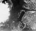
Archivo:Scharnhorst-22.jpg

De Wikipedia, la enciclopedia libre

Ver la imagen en su resolución original(740 × 630 píxeles; tamaño de archivo: 324 kB; tipo MIME: image/jpeg)

Resumen

Descripción
English: Aerial reconnaissance photograph, probably taken by the British Royal Air Force circa February-June 1942. The arrow in the lower center marks the position of the battleship Scharnhorst, which was then under repair at the Kiel navy yard for damage received during the February 1942 "Channel Dash".
Italiano: Fotografia di ricognizione aerea, probabilmente scattata dalla Royal Air Force britannica nel febbraio-giugno 1942. La freccia al centro verso il basso indica la posizione della nave da battaglia Scharnhorst, che era in riparazione nei cantieri navali di Kiel per il danno ricevuto durante l'operazione Cerberus nel febbraio 1942
From contemporary files of the U.S. Office of Naval Intelligence.
Fuente https://www.history.navy.mil/content/history/nhhc/our-collections/photography/numerical-list-of-images/nhhc-series/nh-series/NH-97000/NH-97506.html
 Geotemporal data
Bounding box
N: 54.3440576°N
W: 10.1315523°E E: 10.1883206°E
S: 54.3126398°N
Georeferencing Ver el mapa georreferenciado en Wikimaps Warper

Licencia

Public domain
Este trabajo es obra de un marinero o un empleado de la Marina de los Estados Unidos realizada durante la prestación oficial de servicio. Como obra del gobierno federal de los Estados Unidos de América, esta imagen está en el dominio público.

Historial del archivo

Haz clic sobre una fecha y hora para ver el archivo tal como apareció en ese momento.

Fecha y horaMiniaturaDimensionesUsuarioComentario
actual12:43 17 sep 2005Miniatura de la versión del 12:43 17 sep 2005740 × 630 (324 kB)IgiveupAerial reconnaissance photograph, probably taken by the British Royal Air Force circa February-June 1942. The arrow in the lower center marks the position of the battleship Scharnhorst, which was then under repair at the Kiel navy yard for damage received

Las siguientes páginas usan este archivo:

Uso global del archivo

Las wikis siguientes utilizan este archivo:

Metadatos

Basis of this page is in Wikipedia. Text is available under the CC BY-SA 3.0 Unported License. Non-text media are available under their specified licenses. Wikipedia® is a registered trademark of the Wikimedia Foundation, Inc. WIKI 2 is an independent company and has no affiliation with Wikimedia Foundation.