
Tamaño de esta previsualización: 387 × 600 píxeles. Otras resoluciones: 155 × 240 píxeles · 616 × 955 píxeles.
Ver la imagen en su resolución original (616 × 955 píxeles; tamaño de archivo: 221 kB; tipo MIME: image/jpeg)
Resumen
| Descripción |
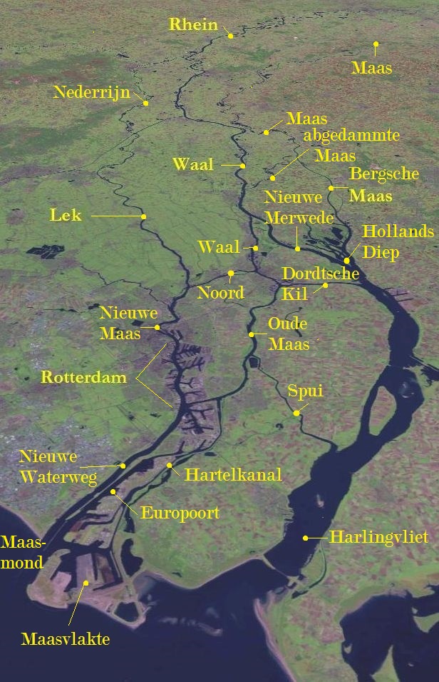
Deutsch: Rhein-Maas-Delta |
| Fecha | |
| Fuente | This image is in the public domain because it is a screenshot from NASA World Wind screenshot. and is public domain. Dieser Screenshot wurde von mir um die Namen der wesentlichen Flüsse des Deltas ergänzt. Basiert auf Bildvorlage: File:Rivieren 4.46933E 51.88083N.jpg. |
| Autor | NASA World Wind, annotations by L.1951a |
Licencia
| Esta imagen se encuentra en el dominio público porque es una captura de pantalla del software de globo terráqueo de la NASA, World Wind, que utiliza una capa de dominio público, como Blue Marble, MODIS, Landsat, SRTM, USGS o GLOBE.
|
 |
das Image ist public domain und auch von mir freigeggeben.
Registro original de carga
Transferido desde de.wikipedia a Commons por Andrei Stroe usando CommonsHelper.
Aquí se muestra la página de descripción original. Los siguientes nombres de usuario se refieren a de.wikipedia.
- 2008-11-02 08:00 L.1951a 1280×958× (197700 bytes) {{Information |Beschreibung = Rhein/Maas Delta |Quelle = Auf Basis :This image is in the public domain because it is a screenshot from NASA’s globe software World Wind using Blue Marble, Landsat or USGS layer, all of which are in public domain, ergänzt
- 2008-11-01 17:25 L.1951a 1280×958× (197896 bytes) {{Information |Beschreibung = Rhein/Maas Delta |Quelle = Auf Basis :This image is in the public domain because it is a screenshot from NASA’s globe software World Wind using Blue Marble, Landsat or USGS layer, all of which are in public domain ergänzt
Historial del archivo
Haz clic sobre una fecha y hora para ver el archivo tal como apareció en ese momento.
| Fecha y hora | Miniatura | Dimensiones | Usuario | Comentario | |
|---|---|---|---|---|---|
| actual | 13:06 2 oct 2021 | | 616 × 955 (221 kB) | <bdi>Erledigt</bdi> | zusätzliche Beschriftungen |
| 22:35 1 oct 2021 |  | 616 × 955 (215 kB) | <bdi>Erledigt</bdi> | Ausschnitt, zusätliche Beschriftung | |
| 21:05 30 ene 2011 |  | 1280 × 958 (193 kB) | <bdi>File Upload Bot (Magnus Manske)</bdi> | {{BotMoveToCommons|de.wikipedia|year={{subst:CURRENTYEAR}}|month={{subst:CURRENTMONTHNAME}}|day={{subst:CURRENTDAY}}}} {{Information |Description={{de|Rhein/Maas Delta}} |Source=Transferred from [http://de.wikipedia.org de.wikipedia]; transferred to Comm |
Usos del archivo
Las siguientes páginas usan este archivo:
Uso global del archivo
Las wikis siguientes utilizan este archivo:
- Uso en als.wikipedia.org
- Uso en ar.wikipedia.org
- Uso en bh.wikipedia.org
- Uso en ca.wikipedia.org
- Uso en da.wikipedia.org
- Uso en de.wikipedia.org
- Uso en el.wikipedia.org
- Uso en en.wikipedia.org
- Uso en en.wikivoyage.org
- Uso en eo.wikipedia.org
- Uso en eu.wikipedia.org
- Uso en fr.wikipedia.org
- Uso en fy.wikipedia.org
- Uso en hu.wikipedia.org
- Uso en id.wikipedia.org
- Uso en ja.wikibooks.org
- Uso en ka.wikipedia.org
- Uso en kw.wikipedia.org
- Uso en nl.wikipedia.org
- Uso en pt.wikipedia.org
- Uso en ro.wikipedia.org
- Uso en ru.wikipedia.org
- Uso en sh.wikipedia.org
- Uso en sl.wikipedia.org
- Uso en uk.wikipedia.org
- Uso en www.wikidata.org
- Uso en zh.wikipedia.org