

Tamaño de esta previsualización: 504 × 600 píxeles. Otras resoluciones: 202 × 240 píxeles · 600 × 714 píxeles.
Ver la imagen en su resolución original (600 × 714 píxeles; tamaño de archivo: 423 kB; tipo MIME: image/png)
Resumen
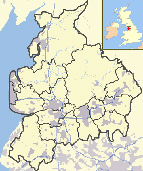
| Descripción | This is a map of ADMINISTRATIVE Lancashire: for a map of The County Palatine of Lancashire follow this link to the Friends of Real Lancashire website:http://www.forl.co.uk/images/maps/FORL_map1.gif Also this article in Wikipedia gives a history of Lancashire and it's division in 1974 into administrative regions.http://en.wikipedia.org/wiki/Lancashire#Modern_history |
| Fecha | |
| Fuente | Trabajo propio |
| Autor | Jhamez84 |
| Otras versiones |
Obras derivadas de ésta: |
Licencia
| Este trabajo ha sido liberado al dominio público por su autor, I, Jhamez84. Esto aplica para todo el mundo. En algunos países esto puede no ser legalmente factible; si ello ocurriese: I, Jhamez84 otorga a cualquier persona el derecho de usar este trabajo para cualquier propósito, sin ningún tipo de condición, a menos que éstas sean requeridas por la ley. |
Historial del archivo
Haz clic sobre una fecha y hora para ver el archivo tal como apareció en ese momento.
| Fecha y hora | Miniatura | Dimensiones | Usuario | Comentario | |
|---|---|---|---|---|---|
| actual | 12:11 25 jun 2008 | | 600 × 714 (423 kB) | <bdi>Jza84</bdi> | Reverted to version as of 13:59, 26 March 2008 |
| 00:35 25 jun 2008 |  | 600 × 714 (448 kB) | <bdi>Jza84</bdi> | Reverted to version as of 13:56, 26 March 2008 - testing darker boundaries | |
| 13:59 26 mar 2008 |  | 600 × 714 (423 kB) | <bdi>Jza84</bdi> | Reverted to version as of 20:12, 21 June 2007 | |
| 13:56 26 mar 2008 |  | 600 × 714 (448 kB) | <bdi>Jza84</bdi> | Reverted to version as of 20:32, 19 June 2007 | |
| 20:12 21 jun 2007 |  | 600 × 714 (423 kB) | <bdi>Jza84</bdi> | making some corrections | |
| 20:32 19 jun 2007 |  | 600 × 714 (448 kB) | <bdi>Jza84</bdi> | {{Information |Description= A map of Lancashire, in Source=self-made |Date=19-06-2007 |Author= [[User:Jhamez84|Jhamez84 }} |
Usos del archivo
No hay páginas que enlacen a este archivo.
Uso global del archivo
Las wikis siguientes utilizan este archivo:
- Uso en en.wikipedia.org
- Uso en ml.wikipedia.org
- Uso en sv.wikinews.org
- Uso en ug.wikipedia.org