

Tamaño de esta previsualización: 419 × 599 píxeles. Otras resoluciones: 168 × 240 píxeles · 335 × 480 píxeles · 537 × 768 píxeles · 716 × 1024 píxeles · 1432 × 2048 píxeles · 8256 × 11 808 píxeles.
Ver la imagen en su resolución original (8256 × 11 808 píxeles; tamaño de archivo: 18,35 MB; tipo MIME: image/jpeg)
Resumen
| Descripción |
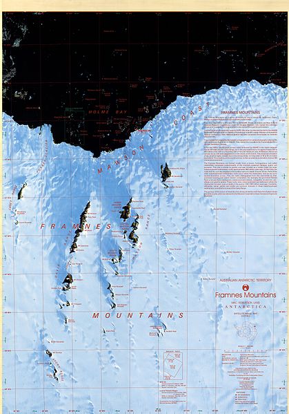
English: Satellite image map of Framnes Mountains, Mac. Robertson Land, Antarctica. This map was produced for the Australian Antarctic Division by AUSLIG (now Geoscience Australia) Commercial, in Australia, in 1997. The map is at a scale of 1:100000, and was produced from SPOT XS (WRS 246-491, 246-490) and Landsat TM (WRS 137-107, 135-108) scenes. It is projected on a Transverse Mercator projection, and shows glaciers/ice shelves, stations/bases, refuges/depots, specially protected areas (SPA), and gives some historical text information. The map has both geographical and UTM co-ordinates. |
| Fecha | |
| Fuente | Framnes Mountains, Mac.Robertson Land |
| Autor | Australian Antarctic Division (Australia) |
| Permiso (Reutilización de este archivo) |
Metadata details |
Licencia
Este archivo se encuentra bajo la licencia Creative Commons Atribución 3.0 Unported.
Atribución: Brolsma, H. (1999, updated 2014) Framnes Mountains Satellite Image Map 1:100000 Australian Antarctic Data Centre - CAASM Metadata (https://data.aad.gov.au/metadata/records/framnes_sat)
- Eres libre:
- de compartir – de copiar, distribuir y transmitir el trabajo
- de remezclar – de adaptar el trabajo
- Bajo las siguientes condiciones:
- atribución – Debes otorgar el crédito correspondiente, proporcionar un enlace a la licencia e indicar si realizaste algún cambio. Puedes hacerlo de cualquier manera razonable pero no de manera que sugiera que el licenciante te respalda a ti o al uso que hagas del trabajo.
Este archivo, el cual fue publicado originalmente en Framnes Mountains, Mac.Robertson Land, fue revisado el 13 January 2017 por el revisor INeverCry, quien confirmó que en esa fecha estaba disponible bajo la licencia indicada.
|
Historial del archivo
Haz clic sobre una fecha y hora para ver el archivo tal como apareció en ese momento.
| Fecha y hora | Miniatura | Dimensiones | Usuario | Comentario | |
|---|---|---|---|---|---|
| actual | 16:03 6 ene 2017 | | 8256 × 11 808 (18,35 MB) | SteinsplitterBot | Bot: Image rotated by 180° |
| 14:47 6 ene 2017 |  | 8268 × 11 812 (18,36 MB) | 4ing | =={{int:filedesc}}== {{Information |description={{en|1=Satellite image map of Framnes Mountains, Mac. Robertson Land, Antarctica. This map was produced for the Australian Antarctic Division by AUSLIG (now Geoscience Australia) Commercial, in Australia,... |
Usos del archivo
La siguiente página usa este archivo:
Uso global del archivo
Las wikis siguientes utilizan este archivo:
- Uso en bg.wikipedia.org
- Uso en ceb.wikipedia.org
- Uso en de.wikipedia.org
- Uso en en.wikipedia.org
- Uso en he.wikipedia.org
- Uso en nn.wikipedia.org
- Uso en www.wikidata.org