

Tamaño de esta previsualización: 600 × 600 píxeles. Otras resoluciones: 240 × 240 píxeles · 480 × 480 píxeles · 768 × 768 píxeles · 1024 × 1024 píxeles · 2048 × 2048 píxeles · 4030 × 4030 píxeles.
Ver la imagen en su resolución original (4030 × 4030 píxeles; tamaño de archivo: 14,71 MB; tipo MIME: image/jpeg)
Resumen
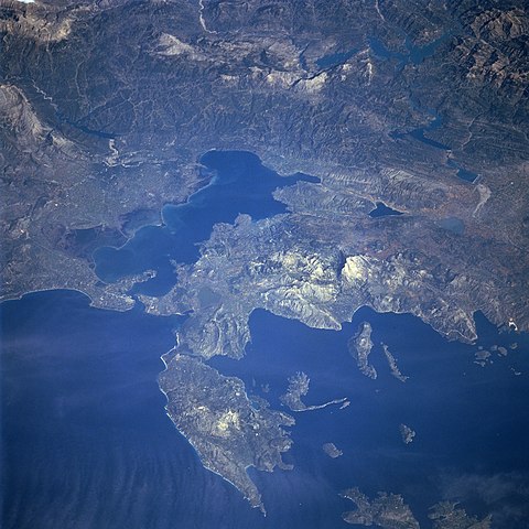
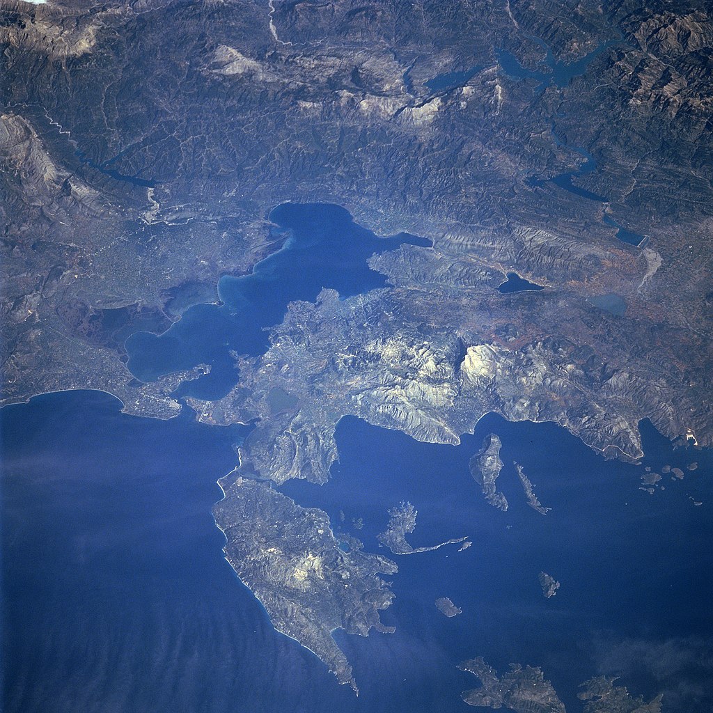
Photograph of the Ambracian Gulf, taken by space-shuttle mission STS-66 in November 1994.
Original caption, from [1] archive copy at the Wayback Machine:
- STS066-101-039 Levkas Island, Ambracian Bay, Greece November, 1994
- The Ambracian Bay, an inlet of the Ionian Sea (bottom left) can be seen in this northeast-looking view. The bay, sometimes referred to as a gulf, is 25 miles 40 km) long and from 4 to 10 miles (6 to 16 km) wide. On the shores of Ambracian Bay are the ruins of several cities important to ancient Greece. Levkas (Leucas) Island is visible in the lower left quadrant of the image. Levkas Island is a mountainous island that covers an area of 115 square miles (300 square km). Olive oil, wine, and tobacco are produced on the island. Covering almost a third of the top portion of the image is the western half of the Pindus Mountains. The Pindus, trending northwest to southeast are a continuation of the Dinaric Alps, but are made up of reduced limestone content compared to the range further to the north. Extending for 100 miles (160 km), the sparsely populated, rugged range is rich in timber. Lake Takhniti, a recreational lake, is discernible in the upper right portion of the image. Ithaki Island is visible near the bottom right of the image.
Este archivo fue catalogado por un de los centros de la Administración Nacional de Aeronáutica y del Espacio (NASA) de los Estados Unidos de Américabajo el identificador de foto: STS066-101-039. Esta etiqueta no indica el estado de los derechos de autor del trabajo adjunto. Se requiere una etiqueta de derechos de autor normal. Para más información vea Commons:Sobre las licencias. Otros idiomas:
|
Licencia
| Este archivo es de dominio público porque fue creado por la NASA. Las políticas sobre copyright de la NASA estipulan que «el material de la NASA no está protegido con copyright a menos que se indique lo contrario». (Políticas sobre copyright de la NASA o Políticas sobre la utilización de imágenes del Jet Propulsion Laboratory). | ||
 |
Advertencias:
|
Historial del archivo
Haz clic sobre una fecha y hora para ver el archivo tal como apareció en ese momento.
| Fecha y hora | Miniatura | Dimensiones | Usuario | Comentario | |
|---|---|---|---|---|---|
| actual | 06:21 28 ago 2005 | | 4030 × 4030 (14,71 MB) | Delirium | Photograph of the Ambracian Gulf, taken by space-shuttle mission STS-66 in November 1994. Original caption, from [http://earth.jsc.nasa.gov/sseop/efs/photoinfo.pl?PHOTO=STS066-101-39]: :STS066-101-039 Levkas Island, Ambracian Bay, Greece November, 1994 T |
Usos del archivo
La siguiente página usa este archivo:
Uso global del archivo
Las wikis siguientes utilizan este archivo:
- Uso en ar.wikipedia.org
- Uso en be-tarask.wikipedia.org
- Uso en bg.wikipedia.org
- Uso en ca.wikipedia.org
- Uso en ceb.wikipedia.org
- Uso en da.wikipedia.org
- Uso en de.wikipedia.org
- Uso en el.wikipedia.org
- Uso en en.wikipedia.org
- Uso en eu.wikipedia.org
- Uso en fa.wikipedia.org
- Uso en fr.wikipedia.org
- Uso en gl.wikipedia.org
- Uso en he.wikipedia.org
- Uso en hr.wikipedia.org
- Uso en hu.wikipedia.org
- Uso en id.wikipedia.org
- Uso en it.wikipedia.org
- Uso en ja.wikipedia.org
- Uso en ko.wikipedia.org
- Uso en la.wikipedia.org
- Uso en nl.wikipedia.org
- Uso en nn.wikipedia.org
- Uso en no.wikipedia.org
- Uso en pl.wikipedia.org
- Uso en pl.wiktionary.org
- Uso en ru.wikipedia.org
- Uso en sh.wikipedia.org
- Uso en sq.wikipedia.org
- Uso en sv.wikipedia.org
- Uso en tr.wikipedia.org
- Uso en uk.wikipedia.org
- Uso en vi.wikipedia.org
- Uso en www.wikidata.org