

Tamaño de esta previsualización PNG del archivo SVG: 397 × 600 píxeles. Otras resoluciones: 159 × 240 píxeles · 318 × 480 píxeles · 508 × 768 píxeles · 678 × 1024 píxeles · 1356 × 2048 píxeles · 864 × 1305 píxeles.
Ver la imagen en su resolución original ((Imagen SVG, nominalmente 864 × 1305 pixels, tamaño de archivo: 767 kB))
| Descripción |
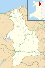
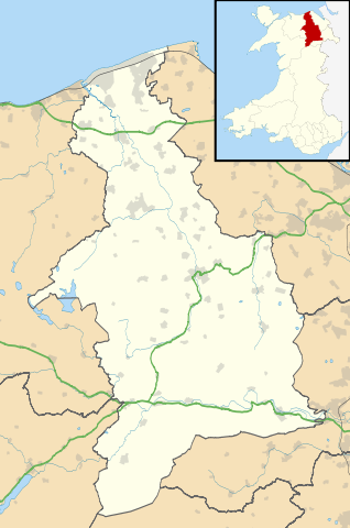
Blank map of Denbighshire, UK with the following information shown:
Equirectangular map projection on WGS 84 datum, with N/S stretched 165% Geographic limits:
|
| Fecha | |
| Fuente |
|
| Autor | Nilfanion, created using Ordnance Survey data |
| Permiso (Reutilización de este archivo) |
Este archivo se encuentra bajo la licencia Creative Commons Genérica de Atribución/Compartir-Igual 3.0. Atribución: Contains Ordnance Survey data © Crown copyright and database right
|
| Otras versiones | File:Denbighshire UK map.svg - Blank map |
Historial del archivo
Haz clic sobre una fecha y hora para ver el archivo tal como apareció en ese momento.
| Fecha y hora | Miniatura | Dimensiones | Usuario | Comentario | |
|---|---|---|---|---|---|
| actual | 19:32 26 sep 2010 | | 864 × 1305 (767 kB) | Nilfanion | {{Information |Description=Blank map of Denbighshire, UK with the following information shown: *Administrative borders *Coastline, lakes and rivers *Roads and railways *Urban areas Equirectangular map projection on WGS 84 datum, with N |
Usos del archivo
Las siguientes páginas usan este archivo:
Uso global del archivo
Las wikis siguientes utilizan este archivo:
- Uso en ar.wikipedia.org
- Uso en azb.wikipedia.org
- Uso en ceb.wikipedia.org
- Uso en cy.wikipedia.org
- Uso en da.wikipedia.org
- Uso en en.wikipedia.org
- Llangollen
- List of monastic houses in Wales
- Ruthin
- Denbighshire
- Rhyl
- St Asaph
- Prestatyn
- Rhuddlan
- Corwen
- Denbigh
- Bodelwyddan
- Gwyddelwern
- Loggerheads, Denbighshire
- Castell Dinas Brân
- Cynwyd, Denbighshire
- Nantglyn
- Llandyrnog
- Glyndyfrdwy
- Llanarmon-yn-Iâl
- Glan Clwyd Hospital
- Denbigh Community Hospital
- H.M. Stanley Hospital
- Llangollen Community Hospital
- Prestatyn Community Hospital
- Ruthin Community Hospital
- Pot Hole quarry
- Llandegla
- Henllan
- Meliden
- Dyserth
- Llanferres
- Llanelidan
- Tremeirchion
- Trefnant
- Llandrillo, Denbighshire
- Cader
- Bodfari
- Bontuchel
- Maeshafn
- RAF Prestatyn
- Llanfair Dyffryn Clwyd
- Tafarn-y-Gelyn
- Eryrys
- User:Arwel Parry/sandbox/Infobox Browser test
Ver más uso global de este archivo.