

Ver la imagen en su resolución original (2394 × 1107 píxeles; tamaño de archivo: 1,47 MB; tipo MIME: image/jpeg)
Resumen
| Descripción |
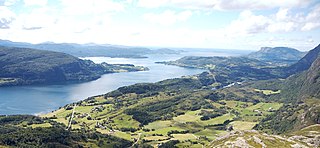
Norsk nynorsk: The image is cropped by me, User:Jorunn Neset ca. midt i biletet, på andre sida av fjorden, er Straumsnes. Innom Straumsnes heiter fjorden Dalsfjorden, utom heiter han Vilnesfjorden. Landet på andre sidan av fjorden er i Fjaler kommune, medan det på den sida der fotografen er er Askvoll. Gardane nedom fjellet/åsen fotografen er på er i Rivedal. Vegen ein ser gå ned mot fjorden til venstre i biletet er Riksveg 609. Vegen ein kan sjå konturane av på andre sida av fjorden er Fylkesveg 394 i Sogn og Fjordane. Vatnet til høgre i biletet er Bakkevatnet. In English (Translation by MyLegAlta) : The point near the centre of the picture, on the other side of the fjord, is Straumsnes. Beyond Straumsnes, the fjord is called Vilnesfjorden, and inland from that point, it is named Dalsfjord. The municipality of Fjaler is on the other side of the fjord, while the photo was taken from the municipality of Askvoll.The farms seen blow the mountain form the which the photo was taken are located in Rivedal. The road on the left side of the picture going down towards the fjord is Riksveg 609. The contour of Fylkesveg 394 can be seen on the other side of the fjord. The body of water on the right of the picture is called Bakkevatnet. |
| Fecha | |
| Fuente | Flickr.com |
| Autor | Jarkko Laine |
Licencia
- Eres libre:
- de compartir – de copiar, distribuir y transmitir el trabajo
- de remezclar – de adaptar el trabajo
- Bajo las siguientes condiciones:
- atribución – Debes otorgar el crédito correspondiente, proporcionar un enlace a la licencia e indicar si realizaste algún cambio. Puedes hacerlo de cualquier manera razonable pero no de manera que sugiera que el licenciante te respalda a ti o al uso que hagas del trabajo.
| Esta imagen, originalmente subida a Flickr, fue revisada el 1 de diciembre de 2008 por el administrador o revisor Mitchazenia, quien comprobó que el archivo se encontraba disponible en Flickr bajo la licencia nombrada en dicha fecha. |
Historial del archivo
Haz clic sobre una fecha y hora para ver el archivo tal como apareció en ese momento.
| Fecha y hora | Miniatura | Dimensiones | Usuario | Comentario | |
|---|---|---|---|---|---|
| actual | 20:33 1 dic 2008 | | 2394 × 1107 (1,47 MB) | Jorunn | {{Information |Description={{nn|1=The image is cropped by me, User:Jorunn Neset ca. midt i biletet, på andre sida av fjorden, er Straumsnes. Innom Straumsnes heiter fjorden Dalsfjorden, utom heiter han Vilnesfjorden. Landet på andre sidan av fjorde |
Usos del archivo
La siguiente página usa este archivo:
Uso global del archivo
Las wikis siguientes utilizan este archivo:
- Uso en ca.wikipedia.org
- Uso en ceb.wikipedia.org
- Uso en da.wikipedia.org
- Uso en en.wikipedia.org
- Uso en eo.wikipedia.org
- Uso en eu.wikipedia.org
- Uso en fi.wikipedia.org
- Uso en fr.wikipedia.org
- Uso en it.wikipedia.org
- Uso en nn.wikipedia.org
- Uso en no.wikipedia.org
- Uso en pl.wikipedia.org
- Uso en ro.wikipedia.org
- Uso en ru.wikipedia.org
- Uso en sl.wikipedia.org
- Uso en sv.wikipedia.org
- Uso en www.wikidata.org
- Uso en zh.wikipedia.org