

Tamaño de esta previsualización: 800 × 600 píxeles. Otras resoluciones: 320 × 240 píxeles · 640 × 480 píxeles · 1024 × 768 píxeles · 1200 × 900 píxeles.
Ver la imagen en su resolución original (1200 × 900 píxeles; tamaño de archivo: 584 kB; tipo MIME: image/jpeg)
Resumen
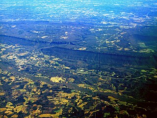
| Descripción | Aerial view of the southern margin of the Cumberland Plateau in NW Georgia. In the lower left there is a tiny portion of the top plateau of Sand Mountain. Above that is a portion of the Lookout Creek valley with the town of Trenton, Georgia, and the Interstate 59. Further up, in about the middle third of the picture there are the steep flanks and the top plateau of the northern portion of Lookout Mountain whose northern tip is at Chattanooga, Tennessee (far outside the left margin of the picture). |
| Fecha | 31 de diciembre de 2004 (fecha original de carga) |
| Fuente | Transferido desde en.wikipedia a Commons por Ævar Arnfjörð Bjarmason. |
| Autor | The original uploader was Pollinator de Wikipedia en inglés. |
| Posición de la cámara | | Ubicación de esta y otras imágenes en: OpenStreetMap |
|---|
Licencia
| Este archivo se encuentra bajo la licencia Creative Commons Genérica de Atribución/Compartir-Igual 3.0. Sujeto a disclaimer. | ||
| ||
| Esta etiqueta de licencia fue agregada a este archivo como parte de la actualización de la licencia GFDL. |

|
Se autoriza la copia, distribución y modificación de este documento bajo los términos de la licencia de documentación libre GNU, versión 1.2 o cualquier otra que posteriormente publique la Fundación para el Software Libre; sin secciones invariables, textos de portada, ni textos de contraportada. Se incluye una copia de la dicha licencia en la sección titulada Licencia de Documentación Libre GNU. Sujeto a disclaimer. |
History on English Wikipedia
- (Delete all revisions of this file) (cur) 17:04, 11 March 2005 . . Naturenet (Talk | contribs | block) . . 1200×900 (598,370 bytes) (Edited version)
- (del) (rev) 09:06, 31 December 2004 . . Pollinator (Talk | contribs | block) . . 1200×900 (1,214,316 bytes) (Cuesta Cumberland Plateau Tennessee)
- (del) (rev) 07:11, 31 December 2004 . . Pollinator (Talk | contribs | block) . . 1200×900 (599,404 bytes) (cuesta Cumberland Plateau Tennessee)
Note: The file description in the second (and several following) version(s) of this commons file page included the comment: “Edited to improve contrast Naturenet 13:05, 11 Mar 2005 (UTC)” This may refer to the youngest edit listed in the orignal file history above, although it is unclear where the 4-hours discrepancy comes from.
| Annotations | This image is annotated: View the annotations at Commons |
Historial del archivo
Haz clic sobre una fecha y hora para ver el archivo tal como apareció en ese momento.
| Fecha y hora | Miniatura | Dimensiones | Usuario | Comentario | |
|---|---|---|---|---|---|
| actual | 06:46 26 oct 2005 | | 1200 × 900 (584 kB) | Ævar Arnfjörð Bjarmason | Escarpment on the Cumberland Plateau, Tennessee by Pollinator. Category:Escarpments |
Usos del archivo
La siguiente página usa este archivo:
Uso global del archivo
Las wikis siguientes utilizan este archivo:
- Uso en de.wikipedia.org
- Uso en fa.wikipedia.org
- Uso en hu.wikipedia.org
- Uso en is.wikipedia.org
- Uso en ja.wikipedia.org
- Uso en ka.wikipedia.org
- Uso en ko.wikipedia.org