To install click the Add extension button. That's it.

The source code for the WIKI 2 extension is being checked by specialists of the Mozilla Foundation, Google, and Apple. You could also do it yourself at any point in time.

4,5
Kelly Slayton
Congratulations on this excellent venture… what a great idea!
Alexander Grigorievskiy
I use WIKI 2 every day and almost forgot how the original Wikipedia looks like.
Live Statistics
Spanish Articles
Improved in 24 Hours
Added in 24 Hours
What we do. Every page goes through several hundred of perfecting techniques; in live mode. Quite the same Wikipedia. Just better.
.
Leo
Newton
Brights
Milds

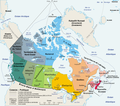
Archivo:Carte administrative du Canada.png

De Wikipedia, la enciclopedia libre

Ver la imagen en su resolución original(1280 × 1128 píxeles; tamaño de archivo: 522 kB; tipo MIME: image/png)

Resumen

Descripción Carte politique du Canada en français
Fecha Original file : March 2006
Translated version : August 2006
Fuente en:Image:Map_Canada_political-geo.png, drawn and adapted by E Pluribus Anthony from Atlas of Canada
Autor Original file : E Pluribus Anthony
This version : Sting with translation indication by fr:User:Boréal
Permiso
(Reutilización de este archivo)
Public domain
Otras versiones Image:Map_Canada_political-fr.png (Canada only, in French)


Français : * Sujet : Carte politique du Canada en français ;

Licencia

Esta imagen ha sido (por este medio) publicada en el dominio público por su autor, E Pluribus Anthony en el proyecto inglés Wikimedia Commons. Esto se aplica mundialmente.

En caso de que no sea legalmente posible:
E Pluribus Anthony garantiza a todos el derecho de usar este trabajo para cualquier propósito, sin ninguna condición, excepto que dichas condiciones sean requeridas por ley.

Public domain This work was previously under Public Domain, or a Free License. It has been digitally enhanced and/or modified. This derivative work has been (or is hereby) released into the public domain by its author, Sting at the French Wikipedia project. This applies worldwide.

In some countries this is not legally possible; if so:
Sting grants anyone the right to use this work for any purpose, without any conditions, unless such conditions are required by law.


English  简体中文‎  繁體中文‎  +/−

Leyendas

Añade una explicación corta acerca de lo que representa este archivo

Elementos representados en este archivo

representa a

e2ddc6be9c0ab53c6289bc5f398fec6339098198

1128 píxel

1280 píxel

Historial del archivo

Haz clic sobre una fecha y hora para ver el archivo tal como apareció en ese momento.

Fecha y horaMiniaturaDimensionesUsuarioComentario
actual20:50 27 ago 2006Miniatura de la versión del 20:50 27 ago 20061280 × 1128 (522 kB)StingOne more translation; font size for a province
18:58 27 ago 2006Miniatura de la versión del 18:58 27 ago 20061280 × 1128 (523 kB)StingMap translated
10:59 27 ago 2006Miniatura de la versión del 10:59 27 ago 20061280 × 1128 (384 kB)<bdi>Wagner51</bdi>{{Atelier graphique}} <div style="padding:0.5em; width:80%; border:1px solid #5555ff; background-color: #eeeeff"> '''fr :''' Carte administrative du Canada, d'après fr:Image:Map Canada political-geo.png.<br /> Certains noms en anglais effacés par

No hay páginas que enlacen a este archivo.

Uso global del archivo

Metadatos

Basis of this page is in Wikipedia. Text is available under the CC BY-SA 3.0 Unported License. Non-text media are available under their specified licenses. Wikipedia® is a registered trademark of the Wikimedia Foundation, Inc. WIKI 2 is an independent company and has no affiliation with Wikimedia Foundation.