To install click the Add extension button. That's it.

The source code for the WIKI 2 extension is being checked by specialists of the Mozilla Foundation, Google, and Apple. You could also do it yourself at any point in time.

4,5
Kelly Slayton
Congratulations on this excellent venture… what a great idea!
Alexander Grigorievskiy
I use WIKI 2 every day and almost forgot how the original Wikipedia looks like.
Live Statistics
Spanish Articles
Improved in 24 Hours
Added in 24 Hours
What we do. Every page goes through several hundred of perfecting techniques; in live mode. Quite the same Wikipedia. Just better.
.
Leo
Newton
Brights
Milds

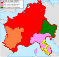
Archivo:Carolingian empire 828.svg

De Wikipedia, la enciclopedia libre

Ver la imagen en su resolución original((Imagen SVG, nominalmente 1091 × 1053 pixels, tamaño de archivo: 348 kB))

Resumen

Descripción
Imperio carolingio en 828 antes de las guerras civiles.
Fecha
Fuente

Trabajo propio

  • [1] Sur l'epoque de la désunion de la Septimanie de Royaume de Aquitaine, & de son érection en Duché, & sur l'acte de partage que fit l'an 817, l'empereur Luis-le-Débonaire de ses Etats entre ses fils.
  • [2] Pepin continued to hold Aquitaine; but the realm sustained various alterations in boundary: only a portion of Septimania, which had hitherto been conjoined with Aquitaine, was retained by him, namely the county of Carcassonne. On the north, the frontier was also somewhat contracted, but the loss was compensated by a dismemberment of Cisjurane Burgundy, three counties -Autun, towering in Roman magnificence: smiling Nevers, and dreary Avalon, where every stone appears stamped with vestiges of once animated nature.
  • [3]: At the Aachen assembly in February 828, Louis the Pious blamed the loss of Lower Pannonia on Balderic of Friuli's "cowardice". Louis the Pious therefore revoked Balderic's honors and divided the match of Friuli into four separate counties: Carantania, Carniola, Istria, and a now greatly reduced Friuli. [...] The province of Carantania at this time passed into the control of the Bavarian king and his eastern prefect. [...] Louis could justify the annexation of Carantania on the basis of the Ordenatio imperii which explicitly included Carantania as part of his Bavarian kingdom. But as the ruler of Italy, Lothar had cotrolled Friuli (including Carantania) since 817. Balderic's downfall in 828 and the resulting Bavarian annexation of Carantania therefore represented Louis's first agressive move against his eldest brother.
  • [4]: Pippin, another son of Lewis, had dominion in Aquitaine and Gascony.
  • [5]: En 817, en Aquisgram, se hizo división entre los hijos de Luis el Piadoso: y Lotario fue asociado al Imperio; Pepino obtuvo la Gascuña y la Aquitania con los territorios de Nevers, Autun, Avallen en la Borgoña.
  • [6]: Pepin continued to hold Aquitaine; but the realm sustained various alterations in boundary : only a portion of Septimania, which had hitherto been conjoined with Aquitaine, was retained by him, namely the county of Carcassonne. On the north, the frontier was also somewhat contracted, but the loss was compensated by a dismemberment of Cisjurane Burgundy, three counties— Autun, towering in Roman magnificence : smiling Nevers, and dreary Avalon, where every stone appears stamped with vestiges of once animated nature.
Autor Trasamundo
Otras versiones

Licencia

Yo, titular de los derechos de autor de esta obra, la publico en los términos de las siguientes licencias:
GNU head Se autoriza la copia, distribución y modificación de este documento bajo los términos de la licencia de documentación libre GNU, versión 1.2 o cualquier otra que posteriormente publique la Fundación para el Software Libre; sin secciones invariables, textos de portada, ni textos de contraportada. Se incluye una copia de la dicha licencia en la sección titulada Licencia de Documentación Libre GNU.
w:es:Creative Commons
atribución compartir igual
Este archivo se encuentra bajo la licencia Creative Commons Attribution-Share Alike 3.0 Unported, 2.5 Generic, 2.0 Generic and 1.0 Generic
Eres libre:
  • de compartir – de copiar, distribuir y transmitir el trabajo
  • de remezclar – de adaptar el trabajo
Bajo las siguientes condiciones:
  • atribución – Debes otorgar el crédito correspondiente, proporcionar un enlace a la licencia e indicar si realizaste algún cambio. Puedes hacerlo de cualquier manera razonable pero no de manera que sugiera que el licenciante te respalda a ti o al uso que hagas del trabajo.
  • compartir igual – En caso de mezclar, transformar o modificar este trabajo, deberás distribuir el trabajo resultante bajo la misma licencia o una compatible como el original.
Puedes usar la licencia que prefieras.

Leyendas

Añade una explicación corta acerca de lo que representa este archivo

Elementos representados en este archivo

representa a

image/svg+xml

6908994735cabc5747629f33d2b509c07bfe85f3

1053 píxel

1091 píxel

Historial del archivo

Haz clic sobre una fecha y hora para ver el archivo tal como apareció en ese momento.

Fecha y horaMiniaturaDimensionesUsuarioComentario
actual12:09 28 oct 2021Miniatura de la versión del 12:09 28 oct 20211091 × 1053 (348 kB)RowanwindwhistlerLighter colours, fake text added for better rendering in articles (real text is now hidden).
08:34 4 may 2016Miniatura de la versión del 08:34 4 may 20161091 × 1053 (251 kB)RowanwindwhistlerSofter colours form http://colorbrewer2.org/
21:38 22 abr 2016Miniatura de la versión del 21:38 22 abr 20161091 × 1053 (251 kB)RowanwindwhistlerClear shapes, some colours from https://en.wikipedia.org/wiki/Wikipedia:WikiProject_Maps/Conventions
18:30 13 mar 2010Miniatura de la versión del 18:30 13 mar 20101091 × 1053 (940 kB)Trasamundolegend
18:26 13 mar 2010Miniatura de la versión del 18:26 13 mar 20101091 × 1053 (940 kB)Trasamundo{{Information |Description={{es|1=Imperio carolingio en 828 antes de las guerras civiles.}} |Source={{own}} |Author=Trasamundo |Date=13 March 2010 |Permission= |other_versions= }} Category:Maps of the Carolingian Empire

Las siguientes páginas usan este archivo:

Uso global del archivo

Metadatos

Basis of this page is in Wikipedia. Text is available under the CC BY-SA 3.0 Unported License. Non-text media are available under their specified licenses. Wikipedia® is a registered trademark of the Wikimedia Foundation, Inc. WIKI 2 is an independent company and has no affiliation with Wikimedia Foundation.