To install click the Add extension button. That's it.

The source code for the WIKI 2 extension is being checked by specialists of the Mozilla Foundation, Google, and Apple. You could also do it yourself at any point in time.

4,5
Kelly Slayton
Congratulations on this excellent venture… what a great idea!
Alexander Grigorievskiy
I use WIKI 2 every day and almost forgot how the original Wikipedia looks like.
Live Statistics
Spanish Articles
Improved in 24 Hours
Added in 24 Hours
What we do. Every page goes through several hundred of perfecting techniques; in live mode. Quite the same Wikipedia. Just better.
.
Leo
Newton
Brights
Milds

Archivo:CPV orthographic NaturalEarth.svg

De Wikipedia, la enciclopedia libre

Ver la imagen en su resolución original((Imagen SVG, nominalmente 550 × 550 pixels, tamaño de archivo: 235 kB))

Resumen

Descripción
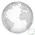
English: A map of the hemisphere centred on Cape Verde, using an orthographic projection, created using gringer's Perl script with Natural Earth Data (1:50000 resolution, simplified to 0.25px). Cape Verde is highlighted in green.
Fecha
Fuente Trabajo propio
Autor Gringer
This is a Grey & green orthographic projection map.
العربية: الرجاء، قراءة الميثاق.
বাংলা: দয়া করে, রীতিনীতিটি পড়ুন
Deutsch: Bitte lies die Konventionen.
English: Please, read the conventions.
Español: Por favor, lea las convenciones.
Français : S'il vous plaît, lisez les conventions.
हिन्दी: कृपया सभागमों को पढ़ लें.
Bahasa Indonesia: Silakan, baca konvensi.
Italiano: Si prega di leggere le convenzioni.
日本語: 規約をご確認ください。
ქართული: გთხოვთ, გაეცნოთ კონვენციებს.
Português: Por favor, leia as convenções.
Русский: Пожалуйста, прочитайте соглашения.
Українська: Будь ласка, прочитайте конвенції.
Tiếng Việt: Hãy đọc công văn trước khi đăng.
中文(繁體):請檢視常規
中文(简体):请查看常规
World maps

Africa

हिन्दी: अफ्रीका
ქართული: აფრიკა.

Eastern Africa

Southern Africa

Central Africa

Northern Africa

Western Africa

Americas

ქართული: ამერიკა.
हिन्दी: अमेरिका

North America

Central America

Caribbean

South America

Asia

ქართული: აზია.
Português: Ásia.
Українська: Азія.

East

Português: Ásia Oriental.
Українська: Східна Азія.

Central

हिन्दी: मध्य एशिया
Português: Ásia Central.
Українська: Центральна Азія.

Southeast

Bahasa Indonesia: Asia tenggara
Português: Sudeste Asiático.

South

(भारतीय उपमहाद्वीप)
Português: Sul da Ásia.
Українська: Південна Азія.

Western

Українська: Передня Азія.

Europe

हिन्दी: यूरोप
ქართული: ევროპა.
Português: Europa.
Română: Europa.
Русский: Европа.
Українська: Європа.

Countries

Oceania

हिन्दी: ओशिआनिया
ქართული: ოკეანეთი.
Português: Oceania.
Українська: Океанія.

Intercontinental

Português: Intercontinental.
Українська: Міжконтинентальні.

Historical

English: Unions, Organizations, Kingdoms, Empires
Español: Uniones, Organizaciones, Reinos, Imperios
Filipino: Mga Unyon, Organisasyon, Kaharian, Imperyo
Français : Unions, Organisations, Royaumes, Empires
हिन्दी: संघ, संगठन, राज्य, साम्राज्य व ऐतिहासिक देश
ქართული: გაერთიანებები, ორგანიზაციები, სამეფოები, იმპერიები
Português: Estados extintos.
Tagalog: Mga Unyon, Organisasyon, Kaharian, Imperyo
Українська: Союзи, Організації, Королівства, Імперії
中文(繁體):聯盟、組織、王國和帝國
中文(简体):联盟、组织、王国和帝国

Subnationals

हिन्दी: उपराष्ट्रीय इकाईयाँ


Licencia

Public domain Yo, el titular de los derechos de autor de esta obra, lo libero al dominio público. Esto aplica en todo el mundo.
En algunos países esto puede no ser legalmente factible; si ello ocurriese:
Concedo a cualquier persona el derecho de usar este trabajo para cualquier propósito, sin ningún tipo de condición al menos que éstas sean requeridas por la ley.

Leyendas

Añade una explicación corta acerca de lo que representa este archivo

Elementos representados en este archivo

representa a

image/svg+xml

85e2c2b69174160bcc059a15eb23ef40546f188f

550 píxel

550 píxel

Historial del archivo

Haz clic sobre una fecha y hora para ver el archivo tal como apareció en ese momento.

Fecha y horaMiniaturaDimensionesUsuarioComentario
actual18:08 13 dic 2019Miniatura de la versión del 18:08 13 dic 2019550 × 550 (235 kB)Goran tek-enAdded border for South Sudan as requested by {{u|Maphobbyist}}
12:27 6 sep 2010Miniatura de la versión del 12:27 6 sep 2010550 × 550 (637 kB)<bdi>Gringer</bdi>slight shading to map area
12:18 6 sep 2010Miniatura de la versión del 12:18 6 sep 2010550 × 550 (637 kB)<bdi>Gringer</bdi>darker country areas, dotted lines, transparency
12:37 3 sep 2010Miniatura de la versión del 12:37 3 sep 2010550 × 550 (584 kB)<bdi>Gringer</bdi>projecting outside the circle
03:58 1 sep 2010Miniatura de la versión del 03:58 1 sep 2010550 × 550 (584 kB)<bdi>Gringer</bdi>blur doesn't appear on thumbnail, so removing
03:55 1 sep 2010Miniatura de la versión del 03:55 1 sep 2010550 × 550 (584 kB)<bdi>Gringer</bdi>zoomed high resolution map of islands
23:40 30 ago 2010Miniatura de la versión del 23:40 30 ago 2010550 × 550 (575 kB)<bdi>Gringer</bdi>{{Information |Description={{en|1=A map of the hemisphere centred on Cape Verde, using an orthographic projection, created using gringer's Perl script with [http://www.naturalearthdata.com/ Natural Earth

Uso global del archivo

Las wikis siguientes utilizan este archivo:

Metadatos

Basis of this page is in Wikipedia. Text is available under the CC BY-SA 3.0 Unported License. Non-text media are available under their specified licenses. Wikipedia® is a registered trademark of the Wikimedia Foundation, Inc. WIKI 2 is an independent company and has no affiliation with Wikimedia Foundation.