

Tamaño de esta previsualización: 776 × 600 píxeles. Otras resoluciones: 311 × 240 píxeles · 621 × 480 píxeles · 994 × 768 píxeles · 1056 × 816 píxeles.
Ver la imagen en su resolución original (1056 × 816 píxeles; tamaño de archivo: 49 kB; tipo MIME: image/png)
Resumen
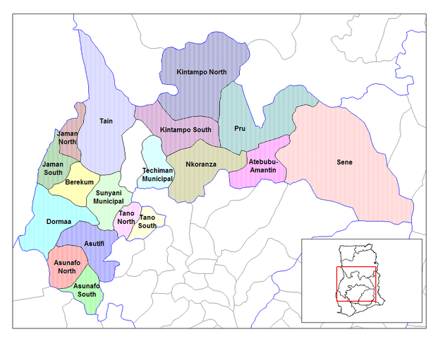
| Descripción | Map of the districts of the Brong Ahafo region of Ghana. Created by Rarelibra for public domain use. Created using MapInfo Professional v7.5 and various mapping resources. |
| Fecha | 28 de junio de 2006 (fecha original de carga) |
| Fuente | No se ha podido leer automáticamente información sobre la fuente; se asume que es trabajo propio (según los derechos de autor reclamados). |
| Autor | No se ha podido leer automáticamente información sobre el autor; se asume que es Ahanta (según los derechos de autor reclamados). |
Licencia
| Yo, el titular de los derechos de autor de esta obra, lo libero al dominio público. Esto aplica en todo el mundo. En algunos países esto puede no ser legalmente factible; si ello ocurriese: Concedo a cualquier persona el derecho de usar este trabajo para cualquier propósito, sin ningún tipo de condición al menos que éstas sean requeridas por la ley. |
Historial del archivo
Haz clic sobre una fecha y hora para ver el archivo tal como apareció en ese momento.
| Fecha y hora | Miniatura | Dimensiones | Usuario | Comentario | |
|---|---|---|---|---|---|
| actual | 10:27 28 jun 2006 | | 1056 × 816 (49 kB) | Ahanta | Map of the districts of the Brong Ahafo region of Ghana. Created by Rarelibra for public domain use. Created using MapInfo Professional v7.5 and various mapping resources. [edit] I, the creator of this work, hereby release it into the public domain. This |
Usos del archivo
Las siguientes páginas usan este archivo:
Uso global del archivo
Las wikis siguientes utilizan este archivo:
- Uso en ca.wikipedia.org
- Uso en ceb.wikipedia.org
- Uso en dag.wikipedia.org
- Uso en da.wikipedia.org
- Uso en de.wikipedia.org
- Uso en dga.wikipedia.org
- Uso en en.wikipedia.org
- Dormaa District
- Asutifi District
- Nkoranza District
- Sene District
- Atebubu District
- Pru District
- Jaman District
- Jaman South Municipal District
- Berekum-Jaman District
- Kintampo District
- Asunafo District
- User talk:Rarelibra/Maps2
- List of hospitals in Ghana
- List of Ghana Parliament constituencies
- Nsoatre
- User:GerardM/Districts of Ghana
- Tano District, Ghana
- Uso en fa.wikipedia.org
- Uso en frr.wikipedia.org
- Uso en fr.wikipedia.org
- District (Ghana)
- District municipal d'Asunafo nord
- District ordinaire d'Asunafo sud
- Asutifi
- Atebubu-Amantin
- District municipal de Berekum
- District municipal de Dormaa
- Jaman nord
- Jaman sud
- Kintampo nord
- Kintampo sud
- Nkoranza sud
- Pru
- Sene-Est
- District municipal de Sunyani
- District de Tain
- Tano nord
- Tano sud
Ver más uso global de este archivo.