

Tamaño de esta previsualización: 800 × 415 píxeles. Otras resoluciones: 320 × 166 píxeles · 640 × 332 píxeles · 1024 × 531 píxeles · 1752 × 908 píxeles.
Ver la imagen en su resolución original (1752 × 908 píxeles; tamaño de archivo: 597 kB; tipo MIME: image/jpeg)
Resumen
| Descripción |
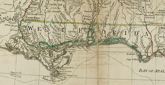
English: The source map depicts the southern British colonies in 1776, including the Carolinas, Georgia, and the Floridas, as well as labeling Indian tribal regions. This detail depicts British West Florida, roughly including the Gulf Coast between the Mississippi River and the Apalachicola River. |
| Fecha | |
| Fuente | From the Darlington Digital Library at the University of Pittsburgh, identifier DARMAP0298: http://images.library.pitt.edu/cgi-bin/i/image/image-idx?med=1;image_search%20btn=Go;q1=florida;rgn1=darlmaps_all;sid=9f1d2a0afbb2d02f51e12f6a87a01616;size=20;c=darlmaps;lasttype=boolean;view=entry;lastview=thumbnail;subview=detail;cc=darlmaps;entryid=x-darmap0298;viewid=DARMAP0298.TIF;start=1;resnum=7 |
| Autor | Bernard Romans |
Licencia
|
Este material está en dominio público en los demás países donde el derecho de autor se extiende por 100 años (o menos) tras la muerte del autor. | |
| Esta obra ha sido identificada como libre de las restricciones conocidas en virtud del derecho de autor, incluyendo todos los derechos conexos. | |
Historial del archivo
Haz clic sobre una fecha y hora para ver el archivo tal como apareció en ese momento.
| Fecha y hora | Miniatura | Dimensiones | Usuario | Comentario | |
|---|---|---|---|---|---|
| actual | 13:02 5 may 2009 | | 1752 × 908 (597 kB) | Magicpiano | {{Information |Description={{en|1=The source map depicts the southern British colonies in 1776, including the Carolinas, Georgia, and the Floridas, as well as labeling Indian tribal regions. This detail depicts British w:West Florida, roughly includ |
Usos del archivo
Las siguientes páginas usan este archivo:
Uso global del archivo
Las wikis siguientes utilizan este archivo:
- Uso en ar.wikipedia.org
- Uso en ca.wikipedia.org
- Uso en en.wikipedia.org
- Uso en fr.wikipedia.org
- Uso en id.wikipedia.org
- Uso en ja.wikipedia.org
- Uso en nl.wikipedia.org
- Uso en ru.wikipedia.org
- Uso en www.wikidata.org