

Tamaño de esta previsualización: 412 × 599 píxeles. Otras resoluciones: 165 × 240 píxeles · 330 × 480 píxeles · 528 × 768 píxeles · 704 × 1024 píxeles · 1667 × 2423 píxeles.
Ver la imagen en su resolución original (1667 × 2423 píxeles; tamaño de archivo: 486 kB; tipo MIME: image/png)
Resumen
| Descripción |
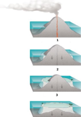
Internationalization of the diagram:Atoll forming. |
| Fuente | http://commons.wikimedia.org/wiki/Image:Atoll_forming.jpg |
| Autor | Susan Mayfield and Sara Boore, modified by Eurico Zimbres |
| Permiso (Reutilización de este archivo) |
Free for all use |
| Otras versiones |
Obras derivadas de ésta: |
Licencia
Esta imagen está en el dominio público, ya que contiene materiales que originalmente vinieron del Servicio Geológico de los Estados Unidos de América, una agencia del Departamento del Interior. Para obtener más información, consulte la política oficial de derechos de los USGS.
|

|
Esta imagen debería volverse a crear como imágenes vectoriales SVG. Esto proporciona muchas ventajas, véase Commons:Media for cleanup (en inglés) para más información. Si ya hay una versión SVG de esta imagen disponible, por favor súbala a Commons. Tras subirla, reemplace esta plantilla con la plantilla
{{vector version available|nuevo nombre de imagen.svg}} en esta imagen. |
Historial del archivo
Haz clic sobre una fecha y hora para ver el archivo tal como apareció en ese momento.
| Fecha y hora | Miniatura | Dimensiones | Usuario | Comentario | |
|---|---|---|---|---|---|
| actual | 18:32 29 may 2006 | | 1667 × 2423 (486 kB) | Zimbres | {{Information |Description= Internationalization of the diagram:Atoll forming.<br> '''1'''=Volcanic Island<br> '''2'''=Fringind reef<br> '''3'''=Barrier reeef<br> |Source=http://commons.wikimedia.org/wiki/Image:Atoll_forming.jpg |Date= |Author=USGS/USGov |
Usos del archivo
La siguiente página usa este archivo:
Uso global del archivo
Las wikis siguientes utilizan este archivo:
- Uso en az.wikipedia.org
- Uso en be-tarask.wikipedia.org
- Uso en be.wikipedia.org
- Uso en eu.wikipedia.org
- Uso en fi.wikipedia.org
- Uso en ja.wikipedia.org
- Uso en kbd.wikipedia.org
- Uso en lt.wikipedia.org
- Uso en mdf.wikipedia.org
- Uso en nn.wikipedia.org
- Uso en pl.wikipedia.org
- Uso en ru.wikipedia.org
- Uso en ru.wiktionary.org
- Uso en uk.wikipedia.org
- Uso en www.wikidata.org