
_png)

Tamaño de esta previsualización: 800 × 497 píxeles. Otras resoluciones: 320 × 199 píxeles · 640 × 397 píxeles · 1024 × 636 píxeles · 1280 × 795 píxeles · 3261 × 2025 píxeles.
Ver la imagen en su resolución original (3261 × 2025 píxeles; tamaño de archivo: 11,8 MB; tipo MIME: image/png)
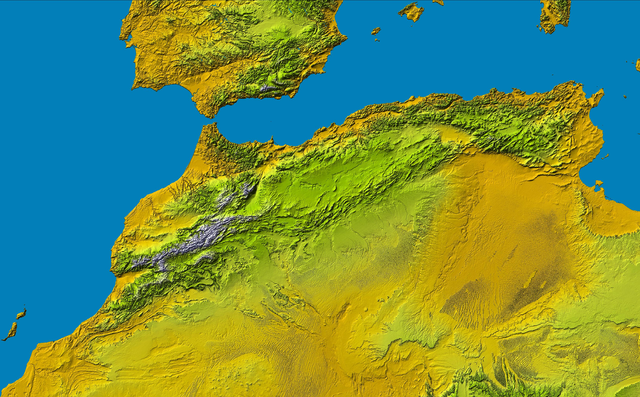
Atlas (Gebirge) a Part of: PIA04965: SRTM Data Release for Africa, Colored Height
Source: http://photojournal.jpl.nasa.gov/catalog/PIA04965
| Este archivo es de dominio público porque fue creado por la NASA. Las políticas sobre copyright de la NASA estipulan que «el material de la NASA no está protegido con copyright a menos que se indique lo contrario». (Políticas sobre copyright de la NASA o Políticas sobre la utilización de imágenes del Jet Propulsion Laboratory). | ||
 |
Advertencias:
|
This image uses high-resolution digital topography data from NASA's Shuttle Radar Topography Mission (SRTM) at JPL-Caltech [4]. It is in the public domain in the United States.
|
 | |
Historial del archivo
Haz clic sobre una fecha y hora para ver el archivo tal como apareció en ese momento.
| Fecha y hora | Miniatura | Dimensiones | Usuario | Comentario | |
|---|---|---|---|---|---|
| actual | 16:16 16 may 2005 | | 3261 × 2025 (11,8 MB) | <bdi>Atamari</bdi> | Atlas (Gebirge) a Part of: PIA04965: SRTM Data Release for Africa, Colored Height Source: http://photojournal.jpl.nasa.gov/catalog/PIA04965 {{GFDL}}{{SpaceShuttle}} Category:Morocco\ |
| 03:15 16 may 2005 |  | 806 × 411 (687 kB) | <bdi>Atamari</bdi> | Atlas (Gebirge) a Part of: PIA04965: SRTM Data Release for Africa, Colored Height Source: http://photojournal.jpl.nasa.gov/catalog/PIA04965 {{GFDL}}{{SpaceShuttle}} Category:Morocco\ |
Usos del archivo
No hay páginas que enlacen a este archivo.
Uso global del archivo
Las wikis siguientes utilizan este archivo:
- Uso en da.wikipedia.org
- Uso en de.wikipedia.org
- Uso en is.wikipedia.org
- Uso en it.wikipedia.org
- Uso en ja.wikipedia.org
- Uso en no.wikipedia.org
- Uso en ru.wikipedia.org
- Uso en tr.wikipedia.org
- Uso en uk.wikipedia.org
- Uso en uz.wikipedia.org
.png)