To install click the Add extension button. That's it.

The source code for the WIKI 2 extension is being checked by specialists of the Mozilla Foundation, Google, and Apple. You could also do it yourself at any point in time.

4,5
Kelly Slayton
Congratulations on this excellent venture… what a great idea!
Alexander Grigorievskiy
I use WIKI 2 every day and almost forgot how the original Wikipedia looks like.
Live Statistics
Spanish Articles
Improved in 24 Hours
Added in 24 Hours
What we do. Every page goes through several hundred of perfecting techniques; in live mode. Quite the same Wikipedia. Just better.
.
Leo
Newton
Brights
Milds

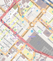
Archivo:Adderley Street map.svg

De Wikipedia, la enciclopedia libre

Ver la imagen en su resolución original((Imagen SVG, nominalmente 546 × 629 pixels, tamaño de archivo: 1,95 MB))

Descripción
Este mapa de Adderley Street, Cape Town fue creado con los datos del proyecto OpenStreetMap, obtenidos por la comunidad. Este mapa puede estar incompleto, y puede contener errores. No se fíe solamente en él para las navegaciones.
Fecha (see file history)
Fuente openstreetmap.org
Creador
OpenStreetMap contributors
Permiso
(Reutilización de este archivo)

OpenStreetMap data is available under the Open Database License (details). Map tiles are licensed under the Creative Commons Attribution-ShareAlike 2.0 license (CC-BY-SA 2.0).

This work contains information from OpenStreetMap, which is made available under the Open Database License (ODbL).

The ODbL does not require any particular license for maps produced from ODbL data. Prior to 1 August 2020, map tiles produced by the OpenStreetMap Foundation were licensed under the CC-BY-SA-2.0 license. Maps produced by other people may be subject to other licences.

w:es:Creative Commons
atribución compartir igual
Eres libre:
  • de compartir – de copiar, distribuir y transmitir el trabajo
  • de remezclar – de adaptar el trabajo
Bajo las siguientes condiciones:
  • atribución – Debes otorgar el crédito correspondiente, proporcionar un enlace a la licencia e indicar si realizaste algún cambio. Puedes hacerlo de cualquier manera razonable pero no de manera que sugiera que el licenciante te respalda a ti o al uso que hagas del trabajo.
  • compartir igual – En caso de mezclar, transformar o modificar este trabajo, deberás distribuir el trabajo resultante bajo la misma licencia o una compatible como el original.
 Geotemporal data
Bounding box
N: 33.9155°S
W: 18.419°E E: 18.43°E
S: 33.926°S
SVG desarrollo
InfoField
 
El código fuente de esta imagen SVG es válido.
 
Este mapa fue creado con una desconocida SVG herramienta

Leyendas

Añade una explicación corta acerca de lo que representa este archivo

Elementos representados en este archivo

representa a

image/svg+xml

796825e29134ebf98d838478264a5e33f1d589f3

629 píxel

546 píxel

Historial del archivo

Haz clic sobre una fecha y hora para ver el archivo tal como apareció en ese momento.

Fecha y horaMiniaturaDimensionesUsuarioComentario
actual21:42 4 oct 2012Miniatura de la versión del 21:42 4 oct 2012546 × 629 (1,95 MB)Htonlupdate
14:35 2 jul 2010Miniatura de la versión del 14:35 2 jul 2010496 × 599 (1,79 MB)Htonlupdate
18:52 19 jun 2008Miniatura de la versión del 18:52 19 jun 2008490 × 548 (1,69 MB)Htonlnew version showing Heerengracht
18:34 19 jun 2008Miniatura de la versión del 18:34 19 jun 2008394 × 383 (1,31 MB)Htonl{{OpenStreetMap|location=Adderley Street, Cape Town|source=OpenStreetMap export tool}} Category:Cape Town {{ImageUpload|basic}}

La siguiente página usa este archivo:

Uso global del archivo

Metadatos

Basis of this page is in Wikipedia. Text is available under the CC BY-SA 3.0 Unported License. Non-text media are available under their specified licenses. Wikipedia® is a registered trademark of the Wikimedia Foundation, Inc. WIKI 2 is an independent company and has no affiliation with Wikimedia Foundation.