

Tamaño de esta previsualización PNG del archivo SVG: 700 × 448 píxeles. Otras resoluciones: 320 × 205 píxeles · 640 × 410 píxeles · 1024 × 655 píxeles · 1280 × 819 píxeles · 2560 × 1638 píxeles.
Ver la imagen en su resolución original ((Imagen SVG, nominalmente 700 × 448 pixels, tamaño de archivo: 1,44 MB))
Resumen
| Descripción |
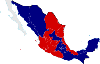
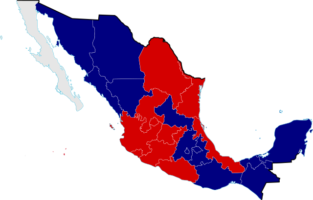
English: Mexico Civil War Division Map in 1858, the Mexican Civil War was one of the episodes of the long struggle between Liberal and Conservative forces that dominated the country's history in the 19th century, because the Liberals wanted a federalist government, limiting traditional Catholic Church and military influence in the country, meanwhile the Conservatives wanted a centralist government, even a monarchy with the Church and military keeping their traditional roles and powers. |
||
| Fecha | |||
| Fuente |
Conservative support
Liberal support
Independent
|
||
| Autor | Giggette | ||
| Atribución (requerido por la licencia) | © Giggette / Wikimedia Commons / | ||
| SVG desarrollo |
| Posición de la cámara | | Ubicación de esta y otras imágenes en: OpenStreetMap |
|---|
Licencia
Yo, titular de los derechos de autor de esta obra, la publico en los términos de las siguientes licencias:
Este archivo se encuentra bajo la licencia Creative Commons Genérica de Atribución/Compartir-Igual 3.0.
- Eres libre:
- de compartir – de copiar, distribuir y transmitir el trabajo
- de remezclar – de adaptar el trabajo
- Bajo las siguientes condiciones:
- atribución – Debes otorgar el crédito correspondiente, proporcionar un enlace a la licencia e indicar si realizaste algún cambio. Puedes hacerlo de cualquier manera razonable pero no de manera que sugiera que el licenciante te respalda a ti o al uso que hagas del trabajo.
- compartir igual – En caso de mezclar, transformar o modificar este trabajo, deberás distribuir el trabajo resultante bajo la misma licencia o una compatible como el original.

|
Se autoriza la copia, distribución y modificación de este documento bajo los términos de la licencia de documentación libre GNU, versión 1.2 o cualquier otra que posteriormente publique la Fundación para el Software Libre; sin secciones invariables, textos de portada, ni textos de contraportada. Se incluye una copia de la dicha licencia en la sección titulada Licencia de Documentación Libre GNU. |
Puedes usar la licencia que prefieras.
Historial del archivo
Haz clic sobre una fecha y hora para ver el archivo tal como apareció en ese momento.
| Fecha y hora | Miniatura | Dimensiones | Usuario | Comentario | |
|---|---|---|---|---|---|
| actual | 21:07 24 may 2013 | | 700 × 448 (1,44 MB) | Giggette | Veracruz |
| 18:36 24 may 2013 |  | 700 × 448 (946 kB) | Giggette | {{Information |Description ={{en|1=c}} |Source ={{own}} |Author =Giggette |Date = |Permission = |other_versions = }} Category:SVG maps of Mexico |
Usos del archivo
Las siguientes páginas usan este archivo:
Uso global del archivo
Las wikis siguientes utilizan este archivo:
- Uso en af.wikipedia.org
- Uso en ar.wikipedia.org
- Uso en br.wikipedia.org
- Uso en en.wikipedia.org
- Uso en ka.wikipedia.org
- Uso en nah.wikipedia.org
- Uso en no.wikipedia.org
- Uso en ro.wikipedia.org
- Uso en ru.wikipedia.org
- Uso en tr.wikipedia.org
- Uso en uk.wikipedia.org
- Uso en www.wikidata.org