
| Zarafshon | |
|---|---|
 The Zarafshon in Ayni District, Tajikistan | |
 The Zarafshon in the Amu Darya basin | |
 Mouth | |
| Location | |
| Country | Tajikistan, Uzbekistan |
| Physical characteristics | |
| Source | Zeravshan Glacier |
| • coordinates | 39°30′N 70°35′E / 39.500°N 70.583°E |
| Mouth | Qorakoʻl oasis |
• coordinates | 39°32′52″N 63°52′08″E / 39.5477°N 63.869°E |
| Length | 877 km (545 mi) |
| Basin size | 17,700 km2 (6,800 sq mi) |
| Basin features | |
| Cities | Panjakent, Samarkand, Bukhara |
| Tributaries | |
| • left | Fan Darya, Kshtut, Magiyan |
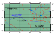

The Zarafshon[2][a][b] (Uzbek & Tajik: Зарафшон, Romanized: Zarafshon) is a river in Tajikistan and Uzbekistan in Central Asia. Its name, "spreader of gold" in Persian, refers to the presence of gold-bearing sands in the upper reaches of the river. To the ancient Greeks it was known as the Polytimetus.[3] It was also formerly known as Sughd River. The river is 877 kilometres (545 mi) long and has a basin area of 17,700 square kilometres (6,800 sq mi).[4]
Geographic position
It rises at the Zeravshan Glacier, close to where the Turkestan Range and the Zeravshan Range of the Pamir-Alay mountains meet, in Tajikistan. In its upper course, upstream from its confluence with the Fan Darya, it is also called Matcha.[5] It flows due west for some 300 kilometres (190 mi), passing Panjakent before entering Uzbekistan at 39°32′N 67°27′E / 39.533°N 67.450°E, where it turns west-to-north-west, flowing past the legendary city of Samarkand, where it feeds the Dargom Canal, which is entirely dependent on the oasis thus created, until it bends left again to the west north of Navoiy and further to the south-west, passing Bukhara before it is lost in the desert beyond the city of Qorakoʻl (Karakul), not quite reaching the Amu Darya, of which it was formerly a tributary.
See also
- Zarafshon, a city in Uzbekistan's Navoiy Region, called "the gold capital of Uzbekistan".
- Zarafshan (disambiguation)
- Zarafshan Bridge
Notes
References
- ^ Samarkand, Uzbekistan
- ^ Abdusamadzoda, Daler; Abdushukurov, Djamshed A.; Duliu, Octavian G.; Zinicovscaia, Inga (23 November 2020). "Assessment of the Toxic Metals Pollution of Soil and Sediment in Zarafshon Valley, Northwest Tajikistan (Part II)". Toxics. 8 (4): 113. doi:10.3390/toxics8040113. PMC 7712287. PMID 33238489.
- ^
 Smith, William, ed. (1857). "Oxia Palus". Dictionary of Greek and Roman Geography. Vol. 2. London: John Murray. p. 505.
- ^ Зеравшан (река в Ср. Азии), Great Soviet Encyclopedia
- ^ "Third National Communication of the Republic of Tajikistan under the United Nations Framework Convention on Climate Change" (PDF). 2014. p. 84.
- Rines, George Edwin, ed. (1920). . Encyclopedia Americana.
Further reading
- В.В. Бартольд "К Истории Орошения в Туркестане" (Collected Works, Vol.3) (Москва) 1965
- V.V. Barthold "Turkestan Down to the Mongol Invasion" (London) 1968
- Robert Lewis "Early Irrigation in West Turkestan" Annals of the Association of American Geographers Vol.56 No..3 (Sept. 1966) pp467–491
- Edgar Knobloch "Beyond the Oxus" (London) 1972
| Rivers | |
|---|---|
| International | |
|---|---|
| National | |