
Yenişehir | |
|---|---|
District and municipality | |
 | |
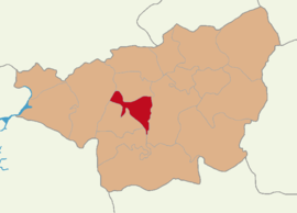 Map showing Yenişehir District in Diyarbakır Province | |
 Yenişehir Location in Turkey | |
| Coordinates: 37°56′N 40°14′E / 37.933°N 40.233°E | |
| Country | Turkey |
| Province | Diyarbakır |
| Area | 358 km2 (138 sq mi) |
| Population (2022)[1] | 219,759 |
| • Density | 610/km2 (1,600/sq mi) |
| Time zone | TRT (UTC+3) |
| Postal code | 21100 |
| Area code | 0412 |
| Website | www |
Yenişehir (Turkish pronunciation: ['jeniʃehiɾ]) is a municipality and district of Diyarbakır Province, Turkey.[2] Its area is 358 km2,[3] and its population is 219,759 (2022).[1] It covers the southwestern part of the city of Diyarbakır and the adjacent countryside. The district Yenişehir was created in 2008 from part of the central district (Merkez) of Diyarbakır.[4][5]
YouTube Encyclopedic
-
1/1Views:1 971
-
#Meslek Lisesi Tanıtımları | Diyarbakır Yenişehir Muazzez Sümer Mesleki ve Teknik Anadolu Lisesi
Transcription
Composition
There are 42 neighbourhoods in Yenişehir District:[6]
- Al
- Alangör
- Alpu
- Aziziye
- Bahçelievler
- Başil
- Bozek
- Çakmak
- Çelikevler
- Çimenler
- Cumhuriyet
- Dicle
- Dikentepe
- Dökmetaş
- Dokuzçeltik
- Dönümlü
- Ekinciler
- Elidolu
- Eser
- Fabrika
- Feritköşkü
- Geyiktepe
- Gürdoğan
- Güvendere
- Güvercinlik
- Güzelköy
- Hantepe
- İlbaş
- Kesikağaç
- Kooperatifler
- Sanayi
- Sancar
- Sarıyatak
- Şehitlik
- Sivritepe
- Tanışık
- Üçkuyu
- Yaytaş
- Yenişehir
- Yolaltı
- Yukarınasırlar
- Yüksek
References
- ^ a b "Address-based population registration system (ADNKS) results dated 31 December 2022, Favorite Reports" (XLS). TÜİK. Retrieved 12 July 2023.
- ^ Büyükşehir İlçe Belediyesi, Turkey Civil Administration Departments Inventory. Retrieved 12 July 2023.
- ^ "İl ve İlçe Yüz ölçümleri". General Directorate of Mapping. Retrieved 12 July 2023.
- ^ Kanun No. 5747, Resmî Gazete, 22 March 2008.
- ^ "İl İdaresi ve Mülki Bölümler Şube Müdürlüğü İstatistikleri - İl ve İlçe Kuruluş Tarihleri" (PDF) (in Turkish). p. 28. Retrieved 25 August 2023.
- ^ Mahalle, Turkey Civil Administration Departments Inventory. Retrieved 12 July 2023.
Yenişehir, Diyarbakır in Diyarbakır Province of Turkey | |||||||||||||||||||||||||||
|---|---|---|---|---|---|---|---|---|---|---|---|---|---|---|---|---|---|---|---|---|---|---|---|---|---|---|---|
| Districts |   | ||||||||||||||||||||||||||
|
Metropolitan municipalities are bolded. | |||||||||||||||||||||||||||
This Kurdistan-related article is a stub. You can help Wikipedia by expanding it. |
This geographical article about a location in Diyarbakır Province, Turkey is a stub. You can help Wikipedia by expanding it. |