
Yaohai
瑶海区 | |
|---|---|
 | |
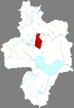 Yaohai in Hefei | |
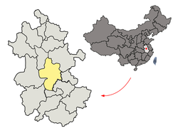 Hefei in Anhui | |
| Country | China |
| Province | Anhui |
| Prefecture-level city | Hefei |
| District seat | Hepinglu |
| Area | |
| • Total | 64.4 km2 (24.9 sq mi) |
| Population (2020) | |
| • Total | 862,043 |
| • Density | 13,000/km2 (35,000/sq mi) |
| Time zone | UTC+8 (China Standard) |
| Postal code | 230011 |
| Website | http://www.hfyaohai.gov.cn/ |
Yaohai District (simplified Chinese: 瑶海区; traditional Chinese: 瑤海區; pinyin: Yáohǎi Qū) is one of four urban districts of the prefecture-level city of Hefei, the capital of Anhui Province, East China. The district has a surface of 142.9 km2 (55.2 sq mi) and a population of 902,830 inhabitants.[1] It contains 1 township, 1 town, 10 subdistricts, 1 industrial park, and 1 development zone.
Administrative divisions
Yaohai District is divided to 14 subdistricts and 1 town.[2]
- Subdistricts
|
|
- Town
- Daxing (大兴镇)
- Other
- Longgang Development Zone (龙岗开发区)
References
- ^ (in Chinese) Compilation by LianXin website. Data from the Sixth National Population Census of the People's Republic of China Archived 2012-03-25 at the Wayback Machine
- ^ 2023年统计用区划代码和城乡划分代码:瑶海区 (in Simplified Chinese). National Bureau of Statistics of China. Archived from the original on 2024-01-23.
External links
- Official government website of Yaohai District (in Chinese)
31°50′31″N 117°18′24″E / 31.84194°N 117.30667°E
This Hefei location article is a stub. You can help Wikipedia by expanding it. |