Yanta
ينطا | |
|---|---|
Village | |
| Country | |
| Governorate | Beqaa |
| District | Rashaya |
| Area | |
| • Total | 12.01 sq mi (31.11 km2) |
| Elevation | 5,050 ft (1,540 m) |
| Alternative name | Yanta |
|---|---|
| Location | north of Kfar Qouq |
| Region | Bekaa Valley |
| Coordinates | 33°36′11″N 35°56′39″E / 33.603056°N 35.944167°E |
| History | |
| Cultures | Roman |
| Site notes | |
| Condition | Ruins |
| Public access | Yes |
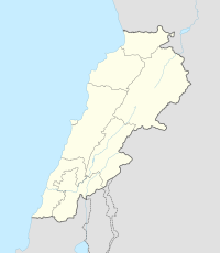
Yanta is a village situated in Rashaya District, Beqaa Governorate, Lebanon, 79 kilometres (49 mi) from Beirut. It is located close to the Syrian border north of Kfar Qouq.[1]
The village sits about 1,540 metres (5,050 ft) above sea level. The name is variously claimed to mean "God sows" or "God the sower" in Semitic, "white dove" in Syriac and "elevation" in Arabic.[2] It has been noted that a special type of yellow marl (lake sediments) has been noticed in Yanta and the surrounding area dated to the Oxfordian.[3] In 2001 and 2002, archaeological studies were carried out at Kamid al lawz near Yanta that unearthed a large amount of Ancient Greek pottery.[4]
YouTube Encyclopedic
-
1/3Views:6133 666770
-
Yanta South Road - Qujiang Xi'an
-
Trip to Lala, Lebanon
-
The Lebanese Army at Irfan School - Rachaya El Wadi
Transcription
Roman temple
There are ruins of an impressively sized and positioned Roman temple in the area that is presumed to have been built on the site of a forerunning Semitic temple.[5][6] The ruins lie on either side of the road and are sparse but retain some upright stones. Around the site are remnants of ancient habitation and tombs.
References
- ^ Anīs Furaiḥa (1972). dictionary of the name of towns and villages in Lebanon. Maktabat Lubnān.
- ^ Qada' (Caza) Rachaya - Promenade Tourist Brochure, published by The Lebanese Ministry of Tourism
- ^ C. Homberg; M. Bachmann (2010). Evolution of the Levant Margin and Western Arabia Platform Since the Mesozoic. Geological Society. p. 232. ISBN 978-1-86239-306-6.
- ^ E. A. Myers (31 January 2010). The Ituraeans and the Roman Near East: Reassessing the Sources. Cambridge University Press. p. 88. ISBN 978-0-521-51887-1. Retrieved 24 April 2011.
- ^ Ivan Mannheim (2001). Syria & Lebanon handbook: the travel guide. Footprint Travel Guides. p. 603. ISBN 978-1-900949-90-3.
- ^ George Taylor (1969). The Roman temples of Lebanon: a pictorial guide, pp. 22, 127, 130. Argonaut.
External links
- Ikema guide to Lebanon - Yanta
- Localiban Entry on Yanta
- The Lebanon Mountain Trail Project
- American University of Beirut - Image of Yanta Roman Temple 1
- American University of Beirut - Image of Yanta Roman Temple 2


