
Yakima Fold Belt
Yakima fold-and-thrust belt | |
|---|---|
 Yakima Fold Belt | |
| Coordinates: 46°24′N 120°30′W / 46.4°N 120.5°W | |
| Location | South-western part of Columbia Basin (Yakima, Kittitas, Klickitat, Benton, and Grant counties) |
The Yakima Fold Belt of south-central Washington, also called the Yakima fold-and-thrust belt, is an area of topographical folds (or wrinkles) raised by tectonic compression. It is a 14,000 km2 (5,400 sq mi) structural-tectonic sub province of the western Columbia Plateau Province[1][2][3] resulting from complex and poorly understood regional tectonics. The folds are associated with geological faults whose seismic risk is of particular concern to the nuclear facilities at the Hanford Nuclear Reservation (immediately northwest of the Tri-Cities) and major dams on the Columbia and Snake Rivers.[4]
YouTube Encyclopedic
-
1/4Views:21 7765653 141483
-
July Evening Public Lecture 2015- The Giant Cascadia Earthquake of January 26, 1700
-
Timeline of United States inventions (1946–1991) | Wikipedia audio article
-
Lessons Learned Presentation In Spokane (Part 1): Intro
-
The Truth - flat /globe earthers: "Lets Talk Hubble Constant" #73
Transcription
Location and extent

The topographical distinctness of the Yakima Folds (see the shaded-relief image) is due to their formation in a layer of lava flows and sedimentary deposits that have filled-in and generally smoothed the topographic surface of a large area of the Columbia Basin. The extent of these lava flows was limited to the west and north by the rising Cascade Mountains and the Wenatchee Mountains. The lava flows extend east well beyond this image, but the Yakima Folds do not. The northernmost fold seen here[5] (Frenchman Hills) ends at the Potholes Reservoir, another (Saddle Mountains) terminates just south of there, near the town of Othello (red circle). South of the Tri-Cities the rampart of the Horse Heaven Hills extends for a short distance past the Columbia River. The ends of these ridges mark the edge of a block of continental crust (part of the North American craton, indicated by the dashed orange line) that has resisted the tectonic compression that formed the ridges.
The southernmost ridge of the Yakima Fold Belt is the Columbia Hills on the north side of the Columbia River. The pattern of folding continues with the Dalles-Umatilla Syncline just south of the Columbia River, and further into Oregon with the Blue Mountains anticline, which approximately parallels the Klamath-Blue Mountain Lineament that marks the southeastern edge of Siletzia (see geological map, below).
The Yakima Fold Belt is also located on, and the orientation and spacing of some of the Folds influenced by, the Olympic–Wallowa Lineament (OWL), a broad zone of linear topographical features (dashed yellow line) extending from the Olympic Peninsula in northwestern Washington to the Wallowa Mountains in northeastern Oregon.
Geology
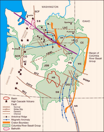
It is the central portion of the Olympic–Wallowa Lineament, referred to as the Cle Elum-Wallula deformed zone (CLEW),[6] constising of a series of generally east-trending narrow asymmetrical anticlinal ridges and broad synclinal valleys formed by folding of Miocene Columbia River basalt flows and sediments.[7][2] In most parts of the belt the folds have a north vergence (Columbia Hills' south vergence is an exception) with the steep limb typically faulted by imbricate thrust faults.[2][8] Fold lengths range from 1 km to 100 km with wavelengths from several kilometers to 20 km.[9]
A graben underlies nearly the entire Yakima Fold Belt and has been subsiding since Eocene time, and continues to sink at a slow rate.[10]
A 2011 report found aeromagnetic, gravity, and paleoseismic evidence that the Yakima Fold Belt is linked to active Puget Sound faults.[11]
Geodesy
Geodetic studies of the Oregon Rotation show that Oregon is rotating about a point somewhat south of Lewiston, Idaho compressing the Yakima fold an average of 3 millimeters per year, and the Washington Pacific coast about 7 millimeters per year.[12]
Studies of the motion of the Yakima Fold Belt have been undertaken to evaluate seismic hazards at the Hanford Site.[13]
See also
Notes and sources
Notes
- ^ Barnett et al. 2013.
- ^ a b c Lidke 2002.
- ^ Reidel, Martin & Petcovic 2003.
- ^ Pratt 2012.
- ^ Some researchers include structures north of this image.
- ^ Reidel et al. 1989, p. 248 "The central part of ... [the] Olympic–Wallowa Lineament (OWL) passes through the central Yakima fold belt. This segment of the OWL is referred to as the Cle Elum-Wallula deformed zone (CLEW)..."
- ^ Reidel et al. 1989.
- ^ Reidel 2004, p. 9.
- ^ Reidel, Martin & Petcovic 2003, p. 91.
- ^ Reidel, Martin & Petcovic 2003, p. 95.
- ^ Blakely et al. 2011.
- ^ Wells et al. 2009 "...folding in the embayment is driven by the clockwise rotation of Oregon about a pole near the OR-WA-ID border, compressing Washington against slow-moving Canada. The folds fan westward from this pole of rotation, and shortening increases to the west to about 7.1 mm/yr between Astoria and Penticton, BC. Shortening across the YFB is about 3 mm/yr and decreases eastward to the Idaho border."
- ^ Last, Winsor & Unwin 2012.
Sources
- Barnett, Elizabeth A.; Sherrod, Brian L.; Norris, Robert; Gibbons, Douglas (2013), "Paleoseismology of a newly discovered scarp in the Yakima fold-and-thrust belt, Kittitas County, Washington", United States Geological Survey, Scientific Investigations Map 3212
- Barrash, W.; Bond, J.; Venkatakrishnan, R. (November 1983), "Structural evolution of the Columbia Plateau in Washington and Oregon", American Journal of Science, 283 (9): 897–935, doi:10.2475/ajs.283.9.897
- Blakely, Richard J.; Sherrod, Brian L.; Weaver, Craig S.; Wells, Ray E.; Rohay, Alan C.; Barnett, Elizabeth A.; Knepprath, Nichole E. (July 28, 2011), "Connecting the Yakima fold and thrust belt to active faults in the Puget Lowland, Washington", Journal of Geophysical Research: Solid Earth, 116 (B7), Bibcode:2011JGRB..116.7105B, doi:10.1029/2010JB008091
- Last, George V.; Winsor, Kelsey; Unwin, Stephen D. (August 1, 2012), A Summary of Information on the Behavior of the Yakima Fold Belt as a Structural Entity — Topical Report, United States Department of Energy Pacific Northwest National Laboratory, PNNL-17471 830403000, doi:10.2172/1053763, OSTI 1053763
- Lidke, D.J., compiler (2002), "Fault number 562b, Saddle Mountains structures, folds and other faults of the Saddle Mountains", Quaternary fault and fold database of the United States: U.S. Geological Survey website, United States Geological Survey, retrieved 2014-08-19
{{citation}}: CS1 maint: multiple names: authors list (link) - Pogue, Kevin R. (2009), "Folds, floods and fine wine: Geologic influences on the terroir of the Columbia Basin", in O'Connor, Jim E.; Dorsey, Rebecca J.; Madin, Ian (eds.), Volcanoes to Vineyards: Geologic Field Trips Through the Dynamic Landscape of the Pacific Northwest (Volume 15 of Geological Society of America Field Guide), Geological Society of America, ISBN 9780813700151
- Pratt, Thomas L. (November 2012), "Large-scale splay faults on a strike-slip fault system: The Yakima Folds, Washington State", Geochemistry, Geophysics, Geosystems, 13 (11), doi:10.1029/2012GC004405
- Reidel, Stephen P.; Fecht, Karl R.; Hagood, Michael C.; Tolan, Terry L. (1989), "The Geologic Evolution of the Central Columbia Plateau", in Reidel, S. P.; Hooper, P. R. (eds.), Volcanism and Tectonism in the Columbia River Flood-Basalt Province, vol. Special Paper 239, Geological Society of America, pp. 247–264, doi:10.1130/SPE239-p247, ISBN 9780813722399
- Reidel, Stephen P.; Martin, Barton S.; Petcovic, Heather L. (2003), "The Columbia River flood basalts and the Yakima fold belt", in Swanson, Terry W. (ed.), Western Cordillera and Adjacent Areas: Volume 4 of Geological Society of America Field Guide, Geological Society of America, p. 91, ISBN 9780813700045
- Reidel, Stephen P. (2004), Northwest Geological Society Field Trips in Pacific Northwest Geology: The Geologic Development of the Pasco Basin, South-Central Washington (PDF), Northwest Geological Society
- Watters, Thomas R. (1989), "Periodically spaced anticlines of the Columbia Plateau", in Reidel, S. P.; Hooper, P. R. (eds.), Volcanism and Tectonism in the Columbia River Flood-Basalt Province, vol. Special Paper 239, Geological Society of America, pp. 283–292, doi:10.1130/SPE239-p283
- Wells, Ray E.; Blakely, Richard J.; Sherrod, Brian L.; Weaver, Craig S. (2009), "The Yakima Fold and Thrust Belt - a paradigm for active shortening in the Columbia embayment from Pasco to the Pacific Ocean", American Geophysical Union, Fall Meeting, vol. 2009, American Geophysical Union, Bibcode:2009AGUFM.S41F..01W, abstract S41F-01
Further reading
- Bentley, Robert D.; Campbell, Newell P.; Powell, John E. (August 1993), Geologic maps of part of the Yakima fold belt, northeastern Yakima County, Washington (PDF), vol. Open File Report 93-3, Washington State Department of Natural Resources Division of Geology and Earth Resources, 13 pages text, 5 plates, scale 1:31,680
- Kuehn, Stephen Christopher (May 1995). "Chapter 1—Introduction | Geologic Setting and Previous Work". The Olympic–Wallowa Lineament, Hite Fault System, and Columbia River Basalt Group Stratigraphy in northeast Umatilla County, Oregon (M.S. Geology). Washington State University Dept. of Geology.
- Norman, David K.; Busacca, Alan J.; Teissere, Ron (June 2004), Geology of the Yakima Valley wine country — a geologic field trip guide from Stevenson to Zillah, Washington (PDF), Washington State Department of Natural Resources Division of Geology and Earth Resources
- Straub, Kristen; Link, Paul (April 2007), "Columbia River Basalt Province Unit", Digital Atlas of Idaho: Digital Geology of Idaho, Idaho State University, Dept. of Geosciences — includes flythrough animations