
32°09′01″N 112°02′41″W / 32.15028°N 112.04472°W

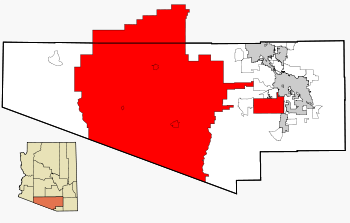
The Tohono Oʼodham Indian Reservation, is an Indian reservation of the Tohono Oʼodham Nation located in Arizona, United States.[1] The reservation had a total 2000 census population of 10,787. The reservation has a land area of 4,340.984 square miles (11,243.098 km2), 97.48 percent of the Tohono Oʼodham Nation total area. The reservation encompasses portions of central Pima, southwestern Pinal, and southeastern Maricopa Counties.
The land is also site of the Quinlan and Baboquivari Mountains, which include Kitt Peak, and the Kitt Peak National Observatory and telescopes, as well as Baboquivari Peak. These astronomical sites are under lease from the Tohono Oʼodham Nation. The lease was approved by the council in the 1950s, for a one-time payment of US$25,000 plus $10 per acre per year.[2]
When the Spaniards first encountered the tribe in 1694, they made note of one of the tribe's inhabited villages called Batki, a site that was later abandoned in about 1850.[3] The village of Batki was located in what is now the Sells District of the Tohono O'odham Nation, in the upper Northwest corner of the reservation.
YouTube Encyclopedic
-
1/5Views:9 0264 42610 050356315
-
TOHONO O'ODHAM TRIBE NATIVE AMERICAN INDIANS TUCSON, ARIZONA U.S. GOVERNMENT FILM 88304
-
Tohono O'odham, Native People of the Sonora Desert
-
Journey For Cultural Preservation A Tohono O'Odham Story CC
-
[4K] San Xavier Indian Reservation - Tucson, AZ - I Got Flicked Off!
-
Santa Rosa, Indian Village, Tohono O'odham Nation, Kaij Mek, Arizona, Indian Route 15, 2021 GX100309
Transcription
Tohono Oʼodham Nation communities
Communications
The telephone area code for the Tohono Oʼodham Reservation is 520.
References
- ^ "Home". Official Website of the Tohono Oʼodham Nation. 2014. Retrieved 2014-04-24.
- ^ "Astronomy Development on Another Sacred Mountain: Kitt Peak". Mauna Kea – From Mountain to Sea. Na Maka o ka Aina. 2005. Archived from the original on 2008-08-20. Reprinting material from the Arizona Daily Star, 2005.
- ^ Fontana, Bernard L.; Robinson, William J.; Cormack, Charles W.; Leavitt, Earnest E. (1962). Papago Indian Pottery. Seattle, Washington: University of Washington Press, on behalf of the American Ethnological Society. pp. 17, 34. OCLC 869680.
- ^ Clement L. Garner, Triangulation in Arizona, p. 141, Washington: US Government Printing Office, 1941.
See also: Indigenous peoples of Arizona |
Municipalities and communities of Maricopa County, Arizona, United States | ||
|---|---|---|
| Cities |  | |
| Towns | ||
| CDPs | ||
| Populated places |
| |
| Indian reservations | ||
| Ghost towns/ former populated places | ||
| Footnotes | ‡This populated place also has portions in an adjacent county or counties | |

Municipalities and communities of Pinal County, Arizona, United States | ||
|---|---|---|
| Cities |  | |
| Towns | ||
| CDPs |
| |
| Populated places | ||
| Indian reservations | ||
| Ghost towns | ||
| Footnotes | ‡This populated place also has portions in an adjacent county or counties | |
| International | |
|---|---|
| National | |
| Other | |