To install click the Add extension button. That's it.

The source code for the WIKI 2 extension is being checked by specialists of the Mozilla Foundation, Google, and Apple. You could also do it yourself at any point in time.

4,5
Kelly Slayton
Congratulations on this excellent venture… what a great idea!
Alexander Grigorievskiy
I use WIKI 2 every day and almost forgot how the original Wikipedia looks like.
Live Statistics
English Articles
Improved in 24 Hours
Added in 24 Hours
What we do. Every page goes through several hundred of perfecting techniques; in live mode. Quite the same Wikipedia. Just better.
.
Leo
Newton
Brights
Milds

Westmoreland County, New South Wales

From Wikipedia, the free encyclopedia

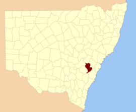
Westmoreland County was one of the original Nineteen Counties in New South Wales and is now one of the 141 Cadastral divisions of New South Wales. It is to the west of Sydney in the Blue Mountains. Coxs River is the border to the north, and the Wollondilly River to the east. Campbells River is the border in the north-east, where the county extends to near Bathurst, with the Fish River part of the border. It includes the town of Oberon, and the Kanangra-Boyd National Park.

Westmoreland County is named in honour of John Fane, Tenth Earl of Westmorland (1759-1841).[1] The Electoral district of Cook and Westmoreland was the first state electoral district for the area, between 1856 and 1859.

YouTube Encyclopedic

  • 1/4
    Views:
    4 788
    358
    7 998
    5 088
  • 725 Squadron Video 2017
  • Part 3 World Famous Beryl Mountain Mine Acworth NH - the Intro
  • Today Show: "Medical assistants: Inside look At Trade Schools"
  • Vietnam War: "Battle of Khe Sanh" pt2-2 1968 Department of Defense

Transcription

Parishes within this county

A full list of parishes found within this county; their current LGA and mapping coordinates to the approximate centre of each location is as follows:

Parish LGA Coordinates
Abercorn Oberon Council 33°59′54″S 149°55′04″E / 33.99833°S 149.91778°E / -33.99833; 149.91778 (Abercorn Parish)
Adderley Oberon Council 33°44′54″S 149°41′04″E / 33.74833°S 149.68444°E / -33.74833; 149.68444 (Adderley Parish)
Antonio City of Lithgow 30°35′54″S 149°58′04″E / 30.59833°S 149.96778°E / -30.59833; 149.96778 (Antonio Parish)
Balfour Oberon Council 33°47′54″S 149°45′04″E / 33.79833°S 149.75111°E / -33.79833; 149.75111 (Balfour Parish)
Banshea Oberon Council 34°02′54″S 150°02′04″E / 34.04833°S 150.03444°E / -34.04833; 150.03444 (Banshea Parish)
Baring Oberon Council 33°42′54″S 149°43′04″E / 33.71500°S 149.71778°E / -33.71500; 149.71778 (Baring Parish)
Bimlow Wollondilly Shire 33°58′54″S 150°23′04″E / 33.98167°S 150.38444°E / -33.98167; 150.38444 (Bimlow Parish)
Bindo City of Lithgow 33°40′54″S 150°02′04″E / 33.68167°S 150.03444°E / -33.68167; 150.03444 (Bindo Parish)
Blenheim Oberon Council 33°36′54″S 149°54′04″E / 33.61500°S 149.90111°E / -33.61500; 149.90111 (Blenheim Parish)
Bolton Oberon Council 33°33′54″S 149°46′04″E / 33.56500°S 149.76778°E / -33.56500; 149.76778 (Bolton Parish)
Bouverie Upper Lachlan Shire 34°19′54″S 149°54′04″E / 34.33167°S 149.90111°E / -34.33167; 149.90111 (Bouverie Parish)
Bulgarres Oberon Council 33°51′54″S 149°57′04″E / 33.86500°S 149.95111°E / -33.86500; 149.95111 (Bulgarres Parish)
Colong Wollondilly Shire 34°07′54″S 150°09′04″E / 34.13167°S 150.15111°E / -34.13167; 150.15111 (Colong Parish)
Crete Oberon Council 33°44′54″S 149°45′04″E / 33.74833°S 149.75111°E / -33.74833; 149.75111 (Crete Parish)
Cyclops Wollondilly Shire 33°54′54″S 150°14′04″E / 33.91500°S 150.23444°E / -33.91500; 150.23444 (Cyclops Parish)
Drogheda Oberon Council 33°55′54″S 149°56′04″E / 33.93167°S 149.93444°E / -33.93167; 149.93444 (Drogheda Parish)
Duckmaloi Oberon Council 33°46′54″S 149°57′04″E / 33.78167°S 149.95111°E / -33.78167; 149.95111 (Duckmaloi Parish)
Ganbenang City of Lithgow 33°40′54″S 150°07′04″E / 33.68167°S 150.11778°E / -33.68167; 150.11778 (Ganbenang Parish)
Gangerang Oberon Council 33°59′54″S 150°10′04″E / 33.99833°S 150.16778°E / -33.99833; 150.16778 (Gangerang Parish)
Guineacor Wingecarribee Shire 34°18′54″S 150°00′04″E / 34.31500°S 150.00111°E / -34.31500; 150.00111 (Guineacor Parish)
Irene Oberon Council 33°44′54″S 149°36′04″E / 33.74833°S 149.60111°E / -33.74833; 149.60111 (Irene Parish)
Jenolan Oberon Council 33°47′54″S 150°05′04″E / 33.79833°S 150.08444°E / -33.79833; 150.08444 (Jenolan Parish)
Jocelyn Oberon Council 33°35′54″S 149°46′04″E / 33.59833°S 149.76778°E / -33.59833; 149.76778 (Jocelyn Parish)
Jooriland Wollondilly Shire 34°11′54″S 150°15′04″E / 34.19833°S 150.25111°E / -34.19833; 150.25111 (Jooriland Parish)
Kendale Oberon Council 33°32′54″S 149°51′04″E / 33.54833°S 149.85111°E / -33.54833; 149.85111 (Kendale Parish)
Konangaroo Oberon Council 33°51′54″S 150°03′04″E / 33.86500°S 150.05111°E / -33.86500; 150.05111 (Konangaroo Parish)
Kowmung Oberon Council 33°57′54″S 149°52′04″E / 33.96500°S 149.86778°E / -33.96500; 149.86778 (Kowmung Parish)
Langdale Oberon Council 33°30′54″S 149°39′04″E / 33.51500°S 149.65111°E / -33.51500; 149.65111 (Langdale Parish)
Leibnitz Wollondilly Shire 34°12′54″S 150°08′04″E / 34.21500°S 150.13444°E / -34.21500; 150.13444 (Leibnitz Parish)
Lowther City of Lithgow 33°35′54″S 150°06′04″E / 33.59833°S 150.10111°E / -33.59833; 150.10111 (Lowther Parish)
Merlin Wollondilly Shire 34°01′54″S 150°14′04″E / 34.03167°S 150.23444°E / -34.03167; 150.23444 (Merlin Parish)
Mozart Oberon Council 33°47′54″S 149°51′04″E / 33.79833°S 149.85111°E / -33.79833; 149.85111 (Mozart Parish)
Murruin Shire 34°07′54″S 150°02′04″E / 34.13167°S 150.03444°E / -34.13167; 150.03444 (Murruin Parish)
Norway Oberon Council 33°44′54″S 149°52′04″E / 33.74833°S 149.86778°E / -33.74833; 149.86778 (Norway Parish)
Oberon Oberon Council 33°36′54″S 149°49′04″E / 33.61500°S 149.81778°E / -33.61500; 149.81778 (Oberon Parish)
Oldbuck Shire 34°13′54″S 150°03′04″E / 34.23167°S 150.05111°E / -34.23167; 150.05111 (Oldbuck Parish)
Speedwell Wollondilly Shire 33°55′54″S 150°17′04″E / 33.93167°S 150.28444°E / -33.93167; 150.28444 (Speedwell Parish)
St Columba Shire 34°11′54″S 150°00′04″E / 34.19833°S 150.00111°E / -34.19833; 150.00111 (St Columba Parish)
Swatchfield Oberon Council 33°51′54″S 149°43′04″E / 33.86500°S 149.71778°E / -33.86500; 149.71778 (Swatchfield Parish)
Tartarus Oberon Council 34°03′54″S 150°06′04″E / 34.06500°S 150.10111°E / -34.06500; 150.10111 (Tartarus Parish)
Terni Wollondilly Shire 34°02′54″S 150°18′04″E / 34.04833°S 150.30111°E / -34.04833; 150.30111 (Terni Parish)
The Peaks Wollondilly Shire 34°06′54″S 150°15′04″E / 34.11500°S 150.25111°E / -34.11500; 150.25111 (The Peaks Parish)
Thornshope City of Lithgow 33°32′54″S 149°59′04″E / 33.54833°S 149.98444°E / -33.54833; 149.98444 (Thornshope Parish)
Thurat Oberon Council 33°56′54″S 150°04′04″E / 33.94833°S 150.06778°E / -33.94833; 150.06778 (Thurat Parish)
Vulcan Oberon Council 33°52′54″S 149°47′04″E / 33.88167°S 149.78444°E / -33.88167; 149.78444 (Vulcan Parish)
Wingecarribee Wollondilly Shire 34°03′54″S 150°22′04″E / 34.06500°S 150.36778°E / -34.06500; 150.36778 (Wingecarribee Parish)

References

  1. ^ "Westmoreland". Geographical Names Register (GNR) of NSW. Geographical Names Board of New South Wales. Retrieved 11 August 2013. Edit this at Wikidata
This page was last edited on 24 August 2019, at 12:54
Basis of this page is in Wikipedia. Text is available under the CC BY-SA 3.0 Unported License. Non-text media are available under their specified licenses. Wikipedia® is a registered trademark of the Wikimedia Foundation, Inc. WIKI 2 is an independent company and has no affiliation with Wikimedia Foundation.