
Westfield Center, Ohio | |
|---|---|
 Church in Westfield Center | |
 Location within the state of Ohio | |
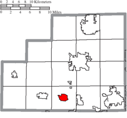 Location of Westfield Center in Medina County | |
| Coordinates: 41°01′42″N 81°55′53″W / 41.02833°N 81.93139°W | |
| Country | United States |
| State | Ohio |
| County | Medina |
| Area | |
| • Total | 2.12 sq mi (5.48 km2) |
| • Land | 2.12 sq mi (5.48 km2) |
| • Water | 0.00 sq mi (0.00 km2) |
| Elevation | 1,106 ft (337 m) |
| Population (2020) | |
| • Total | 1,184 |
| • Density | 559.55/sq mi (216.05/km2) |
| Time zone | UTC-5 (Eastern (EST)) |
| • Summer (DST) | UTC-4 (EDT) |
| FIPS code | 39-83468 |
| GNIS feature ID | 2400152[2] |
| Website | www |
Westfield Center is a village in Medina County, Ohio, United States. The population was 1,184 at the 2020 census. It is the home of Westfield Insurance, the largest employer in Medina County.
YouTube Encyclopedic
-
1/2Views:27 4187 750
-
Danny and Kristen Highlight Wedding Video | Westfield Center, Ohio
-
Westfield Insurance Home Office Campus Tour
Transcription
History
The community was founded in 1826. When it was given a post office, the name "Le Roy" was assigned.[3] The two names were used interchangeably until it was incorporated in 1914 as Le Roy, Ohio. In the early 1970s, the name was changed back to Westfield Center.
One building in Westfield Center, the Universalist Church, has been listed on the National Register of Historic Places.[4]
Geography
According to the United States Census Bureau, the village has a total area of 2.11 square miles (5.46 km2), all land.[5]
Demographics
| Census | Pop. | Note | %± |
|---|---|---|---|
| 1910 | 192 | — | |
| 1920 | 241 | 25.5% | |
| 1930 | 249 | 3.3% | |
| 1940 | 254 | 2.0% | |
| 1950 | 320 | 26.0% | |
| 1960 | 504 | 57.5% | |
| 1970 | 715 | 41.9% | |
| 1980 | 791 | 10.6% | |
| 1990 | 784 | −0.9% | |
| 2000 | 1,054 | 34.4% | |
| 2010 | 1,115 | 5.8% | |
| 2020 | 1,184 | 6.2% | |
| U.S. Decennial Census[6] | |||
2010 census
As of the census[7] of 2010, there were 1,115 people, 450 households, and 349 families living in the village. The population density was 528.4 inhabitants per square mile (204.0/km2). There were 473 housing units at an average density of 224.2 per square mile (86.6/km2). The racial makeup of the village was 97.5% White, 0.1% African American, 0.9% Asian, 0.3% from other races, and 1.3% from two or more races. Hispanic or Latino of any race were 1.3% of the population.
There were 450 households, of which 28.2% had children under the age of 18 living with them, 68.0% were married couples living together, 6.4% had a female householder with no husband present, 3.1% had a male householder with no wife present, and 22.4% were non-families. 19.3% of all households were made up of individuals, and 10.6% had someone living alone who was 65 years of age or older. The average household size was 2.48 and the average family size was 2.83.
The median age in the village was 48.4 years. 20.5% of residents were under the age of 18; 6.3% were between the ages of 18 and 24; 17.8% were from 25 to 44; 32.8% were from 45 to 64; and 22.5% were 65 years of age or older. The gender makeup of the village was 50.6% male and 49.4% female.
2000 census
As of the census[8] of 2000, there were 1,054 people, 401 households, and 336 families living in the village. The population density was 498.8 inhabitants per square mile (192.6/km2). There were 431 housing units at an average density of 204.0 per square mile (78.8/km2). The racial makeup of the village was 99.05% White, 0.09% Native American, 0.28% Asian, 0.19% Pacific Islander, 0.09% from other races, and 0.28% from two or more races. Hispanic or Latino of any race were 0.57% of the population.
There were 401 households, out of which 31.9% had children under the age of 18 living with them, 76.1% were married couples living together, 5.5% had a female householder with no husband present, and 16.0% were non-families. 13.5% of all households were made up of individuals, and 4.5% had someone living alone who was 65 years of age or older. The average household size was 2.63 and the average family size was 2.88.
In the village, the population was spread out, with 24.3% under the age of 18, 5.3% from 18 to 24, 23.1% from 25 to 44, 33.5% from 45 to 64, and 13.8% who were 65 years of age or older. The median age was 42 years. For every 100 females there were 99.6 males. For every 100 females age 18 and over, there were 98.0 males.
The median income for a household in the village was $69,821, and the median income for a family was $76,651. Males had a median income of $55,893 versus $30,083 for females. The per capita income for the village was $30,679. About 2.1% of families and 3.0% of the population were below the poverty line, including 2.0% of those under age 18 and 1.6% of those age 65 or over.
Notable person
- Lois Youngen, player in the All-American Girls Professional Baseball League
Gallery
-
 City street view
 -
 City park
References
- ^ "ArcGIS REST Services Directory". United States Census Bureau. Retrieved September 20, 2022.
- ^ a b U.S. Geological Survey Geographic Names Information System: Westfield Center, Ohio
- ^ U.S. Geological Survey Geographic Names Information System: Westfield Center, Ohio
- ^ "National Register Information System". National Register of Historic Places. National Park Service. July 9, 2010.
- ^ "US Gazetteer files 2010". United States Census Bureau. Retrieved January 6, 2013.
- ^ "Census of Population and Housing". Census.gov. Retrieved June 4, 2015.
- ^ "U.S. Census website". United States Census Bureau. Retrieved January 6, 2013.
- ^ "U.S. Census website". United States Census Bureau. Retrieved January 31, 2008.
External links
Municipalities and communities of Medina County, Ohio, United States | ||
|---|---|---|
| Cities |  | |
| Villages | ||
| Townships | ||
| CDPs | ||
| Other communities | ||
| Footnotes | ‡This populated place also has portions in an adjacent county or counties | |