
Western Connecticut Planning Region | |
|---|---|
Planning region | |
| Western Connecticut Council of Governments (WestCOG) | |
    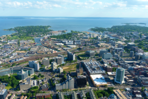 From top left: South Norwalk, Saugatuck River in Westport, Greenwich Point Beach, Candlewood Lake, Downtown Stamford | |
|
Logo | |
 Location within the U.S. state of Connecticut | |
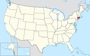 Connecticut's location within the U.S. | |
| Coordinates: 41°19′N 73°29′W / 41.31°N 73.48°W | |
| Country | |
| State | |
| Founded | 2013 |
| Largest city | Stamford |
| Other cities | Norwalk, Danbury |
| Government | |
| • Executive Director | Francis Pickering |
| Area | |
| • Total | 532.1 sq mi (1,378 km2) |
| Population (2020) | |
| • Total | 620,549 |
| Time zone | UTC−5 (Eastern) |
| • Summer (DST) | UTC−4 (EDT) |
| Congressional districts | 4th, 5th |
| Website | westcog |

The Western Connecticut Planning Region is a planning region and county-equivalent in Connecticut. It is served by the coterminous Western Connecticut Council of Governments (WestCOG), one of nine regional councils of governments in Connecticut. Within the region, there are two Metropolitan Planning Organizations, South Western CT MPO and the Housatonic Valley MPO.
The region includes the Connecticut Panhandle, Greater Danbury, and the Gold Coast. In 2022, planning regions were approved to replace Connecticut's counties as county-equivalents for statistical purposes, with full implementation occurring by 2024.[1][2]
YouTube Encyclopedic
-
1/4Views:8863 5191 8212 591
-
Connecticut Stories from the Western Reserve - Lecture
-
Ridgefield's Brutal Battle: Unveiling the Revolutionary War's Epic Clash!
-
Connecticut Native American Communities Past and Present.
-
Connecticut's Paleo-Indian Sites
Transcription
Demographics
| Census | Pop. | Note | %± |
|---|---|---|---|
| 2020 | 620,549 | — | |
| 2022 (est.) | 623,690 | [3] | 0.5% |
| U.S. Decennial Census[2] | |||
As of the 2020 United States census, there were 620,549 people living in the Western Connecticut Planning Region, making it the second most populated region in the state behind the Capitol Planning Region.
Municipalities

The following municipalities are members of the Western Connecticut Region:[4]
Cities
Towns
- Bethel
- Bridgewater
- Brookfield
- Darien
- Greenwich
- New Canaan
- New Fairfield
- New Milford
- Newtown
- Redding
- Ridgefield
- Sherman
- Weston
- Westport
- Wilton
References
- ^ "Governor Lamont Announces U.S. Census Bureau Approves Proposal for Connecticut's Planning Regions To Become County Equivalents". CT.gov. Retrieved March 24, 2023.
- ^ a b "Change to County-Equivalents in the State of Connecticut". Federal Register. June 6, 2022. Retrieved March 24, 2023.
- ^ "U.S. Census Bureau QuickFacts: Western Connecticut Planning Region, Connecticut; United States". www.census.gov. Retrieved 2023-05-13.
- ^ "About". Western Connecticut Council of Governments. Retrieved March 24, 2023.
External links
Municipalities and communities of Western Connecticut Planning Region, Connecticut, United States | ||
|---|---|---|
| Cities |  | |
| Towns | ||