
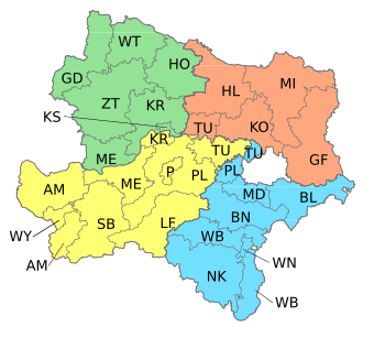
| Quarters and districts of Lower Austria |
|---|
|
|
The Weinviertel (German: [ˈvaɪ̯nˌfɪʁtl̩] ⓘmeaning "wine quarter"; Czech: Vinná čtvrť; Slovak: Vínna štvrť) or Viertel unter dem Manhartsberg ("area below the Manhartsberg": Czech: oblast pod Manhartsbergem; Slovak: oblasť pod Manhartsbergem) is located in the northeast of Lower Austria.
In the east, the Weinviertel borders Slovakia at the March River. In the south, it borders Mostviertel and Industrieviertel, its limits being the Wagram, the Danube and the Marchfeld. Its western neighbor is Waldviertel, the traditional border being the Manhartsberg. In the north, the Weinviertel is adjacent to the Czech Republic, more specifically Moravia. The river Thaya runs back and forth across the border.
YouTube Encyclopedic
-
1/3Views:7 9144 286988
-
Weinviertel - Das weite Land
-
Weinviertel - Land of a Thousand Vineyards - The Secrets of Nature
-
Kellergassen im Weinviertel
Transcription
Viticulture
The name Weinviertel is derived from viticulture; it is Austria's largest wine growing area. The most important grape varieties are:
Geography


Other important rivers are Göllersbach, Hamelbach, Pulkau, Rußbach, Schmida, Waidenbach, Weidenbach and Zaya.
Beside viticulture and agriculture, other industries contribute to the Weinviertel economy. Most notably, there are some oil fields in its eastern part, which are exploited by OMV and located in the "oil communities" of Neusiedl an der Zaya, Zistersdorf, Matzen, Auersthal and Prottes.
Important rail connections are Franz Josef Railway, the North railway and the East railway.
Districts
The following administrative districts of Lower Austria are considered to be parts of the Weinviertel
- Gänserndorf
- Hollabrunn
- Korneuburg
- Mistelbach
- The court district of Kirchberg am Wagram, which is part of the administrative district of Tulln)
Culture
References
External links
 Media related to Weinviertel at Wikimedia Commons
- Visitor Information - official Website
48°28′40″N 16°30′50″E / 48.477906°N 16.513932°E
| International | |
|---|---|
| National | |