

Wapsie is an unincorporated community in Franklin Township in Bremer County, Iowa, United States.
Geography
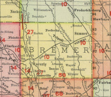
Wapsi is in section 6 of Franklin Township.[1] It is at the junction of Sable Avenue and Iowa Highway 3 (230th Street).[2]
History
Wapsie was founded one mile west of the banks of the Wapsipinicon River. The Wapsie post office opened on October 10, 1890, and closed on January 14, 1905.[3]
Wapsie's population was 25 in 1887,[4] was 27 in 1902,[5] and was 21 in 1917.[6]
The community of Wapsie in Bremer County is not to be confused with the town of Bailey, formerly known as Wapsie, in Mitchell County; both communities were near the Wapsipinicon River, but in different parts of the state. Wapsie has also been spelled Wapsi.[7]
References
- ^ Howe, Samuel Storrs; Parvin, Theodore Sutton; Lloyd, Frederick; Huff, Sanford W.; Aldrich, Charles; Harlan, Edgar Rubey (1929). Annals of Iowa. Iowa State Historical Department, Division of Historical Museum and Archives. p. 450.
- ^ Iowa Atlas and Gazetteer. Yarmouth, ME: Garmin, Ltd. 2021. p. 31.
- ^ "GNIS Detail - Wapsie Post Office (historical)". geonames.usgs.gov. Retrieved 2021-07-25.
- ^ Cram, George Franklin (1887). Cram's Universal Atlas: Geographical, Astronomical and Historical, Containing a Complete Series of Maps of Modern Geography, Illustrated by Numerous Views and Charts ; the Whole Supplemented with Valuable Statistics, Diagrams, and a Complete Gazetteer of the United States. G.F. Cram. pp. 367–369.
- ^ Cram's Modern Atlas: The New Unrivaled New Census Edition. J. R. Gray & Company. 1902. pp. 203–207.
- ^ Atlas of Johnson County, Iowa, 1917 :: Iowa Counties Historic Atlases. pp. 63–66.
- ^ Grawe, Joseph F. (1914). History of Bremer County, Iowa: A Record of Settlement, Organization, Progress and Achievement. S. J. Clarke publishing Company. p. 240.
External links
Municipalities and communities of Bremer County, Iowa, United States | ||
|---|---|---|
| Cities |  | |
| Townships | ||
| Unincorporated community | ||
| Footnotes | ‡This populated place also has portions in an adjacent county or counties | |